
Gajendra Thakur
A PARALLEL HISTORY OF MITHILA & MAITHILI LITERATURE- PART 21
The River Whisperer: Dinesh Kumar Mishra's Quest for Mithila's Soul

EVER NEW DINESH KUMAR MISHRA
NIT NAVAL DINESH KUMAR MISHRA
Table of Contents
Nita Naval Dinesh Kumar Mishra: Introduction – Bandini Mahananda (1994)
Bagavat Par Majboor Mithila Ki Kamla Nadi (2004) (1994)
Bhutahi Nadi Aur Takniki Jhad-Phook (2005)
Dui Patan Ke Bich Mein- Kosi Nadi Ki Kahani (2006)
Na Ghaat Na Ghar – Refugees of the Kosi Embankments (2008)
Bagmati Ki Sadgati (2010)
The Myth of Flood Control (2014)
Pani Ka Shaap: Bihar Mein Baadh-Sukhad (2026)
Nita Naval Dinesh Kumar Mishra: Book Conclusion
Bibliography
Nita Naval Dinesh Kumar Mishra: Introduction
Dinesh Kumar Mishra, the floods of Mithila, and the embankments / dams built on the currents
References: Bandini Mahananda (1994); Bagavat Par Majboor Mithila Ki Kamla Nadi (2004); Bandini Mahananda (1994); Bhutahi Nadi Aur Takniki Jhad-Phook (2005); Dui Patan Ke Bich Mein- Kosi Nadi Ki Kahani (2006); Na Ghaat Na Ghar – Refugees of the Kosi Embankments (2008); Bagmati Ki Sadgati (2010); The Myth of Flood Control (2014); Pani Ka Shaap: Bihar Mein Baadh-Sukhad (2026)
Author's Introduction and Scholarly Philosophical Background
Dinesh Kumar Mishra's personality and work are an achievement in the discourse on rivers in Bihar. He was born in 1946 in Azamgarh, Uttar Pradesh, but his field of work was the floodplains of the Kosi, Kamla, Bagmati, and Gandak rivers in Bihar. A graduate (1968) and postgraduate (1970) in Civil Engineering from IIT Kharagpur, Mishra ji's perspective, while deeply technical, is also profoundly imbued with human sensitivity. In 2006, he obtained a Ph.D. from South Gujarat University. His doctoral research was also based on the historical and technical aspects of floods and water management.
His journey into flood research began in 1984 after the Saharsa section of the Kosi embankment broke. Witnessing the plight of the displaced people there, he decided to document the history of floods and droughts in Bihar. Mishra ji believes that embankments and dams are not sufficient to stop floods; rather, they often exacerbate the catastrophe. He has worked with over 700 village groups through the 'Flood Liberation Movement' (BMA), whom he calls 'flood historians'. Mishra ji's main argument is that the current 'top-heavy' flood control policy has failed. He advocates for the restoration of traditional water management systems and the cultural ownership of the people.
Dinesh Kumar Mishra is introduced as an engineer trained at IIT Kharagpur, but his identity is more firmly established as a 'historian' and 'folk engineer' of Mithila's rivers. His research journey began in 1984 after the breach of the Kosi embankment at Hempur village in the Nauhatta block of Saharsa district.
While working in Saharsa at that time, Mishra ji experienced that the measures taken for flood control (embankments), which were built to protect the people, had not reduced the devastation of floods but had actually made it more severe. "Bagavat Par Majboor Mithila Ki Kamla Nadi" is the essence of that ideological shift, where he advocates for local traditional knowledge instead of technical hubris.
This book by Dinesh Kumar Mishra is not a government report, but rather a cry from the soil of Mithila. He emphasizes traditional flood management (where river water was allowed to spread by diverting it). He believes that if engineering only diverts the flow of water instead of removing sand, it is nothing more than "technical exorcism." Ultimately, the river itself renders the final judgment.
The rivers hold a central place in the geographical, cultural, and economic structure of North Bihar. Numerous streams originating from the Himalayas give both fertility and destruction to the plains of Mithila. In this context, "Bhutahi Balan" is not just the name of a river, but a living document of an ecological crisis and governmental failure. Dr. Dinesh Kumar Mishra, who dedicated his entire life to the study and public dialogue on the rivers of North Bihar, presents in his work "Bhutahi Balan: Story of a Ghost River and Engineering Witchcraft" a serious critique of the water policy of this region. This report presents a detailed analysis of the historical, geographical, and sociological aspects of Bhutahi Balan in the light of Dinesh Kumar Mishra's research, experience, and the interconnections of folk life in Mithila.
Understanding the personality and work of Dr. Dinesh Kumar Mishra is essential for understanding the river discourse in North Bihar. Born in a village in Uttar Pradesh in 1948, Dr. Mishra began his career as an engineer, but his mind remained engaged in exploring the untouched aspects of rivers. After graduating in Civil Engineering from IIT Kharagpur in 1968, he did not limit his research to just concrete and iron. He felt that the modern engineering paradigm imposed on North Bihar is contrary to the nature of the rivers.
Forty years of research into newspapers at the National Library in Kolkata and the study of legislative debates were decisive in his intellectual development. This led to his first book, "Those Afflicted by Flood", inspired by which he left his professional career to become a full-time river activist and researcher. Dr. Mishra is often called a "walking encyclopedia of Bihar's rivers", because his knowledge is not just bookish, but is embedded in village folklore, songs, myths, and poetry. He is a polyglot scholar who can converse fluently in Maithili, Hindi, English, Bengali, Odia, and Urdu.
Dr. Mishra's greatest contribution is the establishment of the "Flood Liberation Movement" (BMA), a network of over 700 villages' "flood historians". This organization teaches people how their ancestors lived in harmony with floods before the construction of embankments. His research has been awarded the Ashoka Fellowship and several prestigious honors.
The literature composed by Dr. Mishra can be called the 'biography' of every major river in North Bihar. His writing style is a unique confluence of technical precision and human sensitivity.
................................................................
The land of Mithila has been struggling with the devastation of floods. The Kushweshwarsthan area often gets submerged even without floods, simply during the rainy season. But this situation is post-1978-79. Earlier that region was completely fertile, but with the unbridled construction of embankments in India, water started accumulating there. However, no news of floods from that area ever comes; if it does, it is only propaganda that this water is a collection of water released from Nepal. The people of the Kushweshwarsthan area have learned the art of dealing with this new crisis. I recall the scene when, during a flood, I was asked to come from Kushweshwarsthan to Mahishi Ugratarasthan because it was easier to travel by boat at that time – it was said. During the khutta-chabchacha season, boats cannot operate, and the condition of the roads is beyond question. The pattern of crops changed; somehow, through practices like fishing, this region forcibly learned a new life skill. The 2008 calamity of Kaushiki (Kosi) was able to end this propaganda. Previously, we all saw who controls the two barrages in Nepal on the Kosi and Gandak? This control lies with the Water Resources Department of the Bihar government, and engineers of the Bihar government have control here. The decision to release water is in the hands of the Water Resources Department of the Bihar government. Nepal would have the right to release water only if a dam/embankment were built on some other channel, but even after more than 50 years, no agreement has been possible between the two countries. Why? The Bhimnagar Barrage on the Kosi, in Kushaha, Nepal, was built in 1958. Its lifespan was fixed at 30 years, which ended in 1988. Why couldn't an agreement be reached between the two countries? The sand accumulating in the middle of the dam is removed every year. If not removed, its height keeps increasing, then the height of the embankment has to be increased every year. In the year this work is not started on time, a catastrophe occurs that year. The same happened in 2008; the rains started, and on August 18th, a 2-meter crack appeared in the Kosi embankment. I have seen the 1987 flood with my own eyes. Near the Jhajharpur embankment, water overflowed from one place, and right before my eyes, I saw how a 1-meter crack turned into a kilometer. By August 27-28, 2008, this breach at the Bhimnagar Barrage had become 2 kilometers. The reason was the Kosi leaving its main channel, taking a new course, and devastating Mithilanchal in Nepal along with Mithilanchal in Bihar. NASA images from August 8, 2008, and August 24, 2008, showed a distance of 200 kilometers between the Kosi's new and old channels. The Bhimnagar Barrage had now become a barrage built on a tributary of the Kosi. When a disaster strikes a state, it requests assistance from the center. A central minister's team tours the state and submits a report, based on which another central minister's team decides whether this disaster is a national disaster or not. While the politicians of Bihar, forgetting their own fifty years of failure, started accusing each other, Prime Minister Manmohan Singh toured the area and declared it a national disaster. Because this was a level-three disaster and for the concerned state – neither in terms of finance nor in terms of relief management capability – it was impossible to cope. Then assistance was given from the National Contingency Disaster Fund, and farmers' loans were also waived. The disaster at Kusheshwar Sthan comes every year, and it gets forgotten each time. Why projects like the Damodar Valley and Mayurakshi were not possible on the Kosi, Kamla, Bhutahi Balan, Gandak, Burhi Gandak, and Bagmati? Why is Visvesvaraya's Vrindavan Dam successful? How long will we keep deceiving the public by blaming the Nepal government? The only solution is to break and remove the earthen embankments built on Kamla-Balan etc. with large machinery and construct pucca canals instead of kutcha ones. A quick solution should be reached by talking with the Nepal government. And until that happens, whatever short-term measures are available should be done, like removing the sand between the embankments before the rains, carry out embankment repair work beforehand instead of waiting for the rains to come, and keep political ambitions away from all this. To bring the Kosi back to its old course, many embankments would have to be built, and they can never be a solution. Learn from the benefits and harms of the Kamla channel's canals. On one hand, a kutcha canal and on top of that, fundamental design issues; one example is enough for all such haphazardly built projects. The main canal taken out from the Kamla current towards the west is in the direction from Jaynagar to Umrao – east to west. But there, the slope of the land is from north to south. What would be the result during the rainy season? What is the result? This embankment gets built, and water accumulates to its north. Every year, due to this canal-like embankment, whether Patna gets flooded or not, the crops in the northern side are definitely destroyed. The direction of the canal is changed so that Mr. So-and-so's land is not taken into the canal! Embankment was constructed on the Kamla river from Jaynagar to Jhajharpur in 1960, and this started the devastation of the entire area. The condition of the area beyond Jhajharpur is clear from the description of Kusheshwar. The stories of Madhepura, Ghanshyampur, Singhia are no different from Kusheshwar. As sand filled up between the two embankments of Kamla-Balan, everything was destroyed within twenty years of the construction of these embankments. The Kamla current, which merged with Balan near Pipraghat in 1954, due to a large log obstruction flowing from the Himalayas. Now, the situation is such that the water level in this current can rise by more than 2 meters in ten hours. From 1965 onwards, so much sand filled between the embankments that it became necessary to increase their height, and demands started that the embankments be broken! The Kosi's water comes from Mount Everest, Kanchenjunga, Gauri-Shankar peaks, and the Makalu mountain range. In Nepal, it is the Saptakoshi, which includes the Indravati, Sunkosi (Bhot Kosi), Tamba Kosi, Likhu Kosi, Dudh Kosi, Arun Kosi, and Tamar Kosi. Among these, Indravati, Sunkosi, Tamba Kosi, Likhu Kosi, and Dudh Kosi combine to form the Sunkosi, which flows roughly from west to east; its branches roughly flow from north to south. These five currents bring water from the Gauri Shankar peak and the Makalu mountain range. The Arun Kosi receives water from the Mount Everest (Sagarmatha) region. This current flows roughly north-south. The Tamar Kosi flows roughly east-west and receives its water from the Kanchenjunga mountain range. Now these three branches – Sunkosi, Arun Kosi, and Tamar Kosi – meet at Triveni in Dhankuta district to form the Saptakoshi. Ten kilometers further downstream is Chatra, where the Mahakosi, Saptakoshi, or Kosi emerges onto the plains. Now, flowing north-south, the North Kosi, after about fifty kilometers in Nepal, enters India near Hanumannagar-Bhimnagar, and after turning somewhat south-west, it takes a south-east and west-east direction and flows about 130 km in India before merging with the Ganga near Kursela. The Bagmati and Kamla currents also join the Kosi at the confluence of Saharsa-Darbhanga-Purnia districts. The first dam on the Kosi was the 'Vir-Bandh' built in the 12th century by Lakshmana II, whose remnants are still present south of Bhimnagar. With the construction of the barrage near Bhimnagar, the Eastern Kosi embankment and the Eastern Kosi canal were also built. The Kunwar Sen Commission in 1966 proposed a plan for a barrage at Dgarmara, 23 km downstream from Bhimnagar, for Kosi control, which got lost in debate and politics. There were two advantages to this barrage. Firstly, if the life of the Bhimnagar Barrage ended, this barrage could function; secondly, it would develop inland water transport from Uttar Pradesh to Assam, which would greatly benefit North Bihar. However, the central irrigation minister, Dr. K.L. Rao, did not allocate funds for the construction of this barrage. The Western Kosi Canal was started as an alternative at a slow pace, but work on it is still ongoing. Nothing could be done for the Kosi. Ideas came, plans were rejected. For as many days as the work was supposed to be completed, disputes continued for that many days; a cheaper plan was approved instead of the Dgarmara Barrage plan, but even that kept waiting for completion! In this, Visvesvaraya comes to mind. A dam was built on the Musi and its tributaries, located about 16 miles from Hyderabad, and a tributary of the Musi was built 6.5 miles from the city. Along with that, embankments were built on both sides of the river in the city. When the proposed plan for the 130-foot high Krishnaraja Sagar Dam was sent by the Mysore state to the English, Viceroy Hardinge reduced it to 80 feet. Visvesvaraya compensated for this by increasing the width of the lower part. When a flood came in between, he compensated for the lost time by employing extra laborers, treating malaria and other diseased laborers, hiring doctors, installing Washington lamps at night, and through personal supervision. Such was the patriot that he did not import cement; instead, he built the dam using 'surkhi' made by mixing sand, calcium, stone, and burnt brick powder. Before the dam's construction, a two-tiered canal system was built. It is necessary that funds from the Prime Minister's Disaster Fund and the Chief Minister's Disaster Fund are not wasted; simultaneously, pressure should be put on the government to declare holidays during floods instead of during the summer heat. Let alone CBSE and ICSE, even the Bihar Board has not been able to do this. The Dgarmara Barrage plan in India should be initiated, because the Bhimnagar Barrage has completed its lifespan. Funds for this should be taken from both the Railway and Road Ministries because a rail and road can also be built on it, and should be. During the period of barrage construction, pucca canals should be built according to the slope of the land. All kutcha embankments should be broken and removed, and pucca embankments should be made motorable, with adequate trees planted on both sides of the embankment. Just as road projects in Bihar are being realized like a dream, similarly, removing all obstacles, work on all these should be started on a war footing. If the embankment started in the 12th century had been completed, rivers could have become the servants of humanity.
Now presented is a summary of Dinesh Kumar Mishra ji's research, in Maithili, from time to time...
Bandini Mahananda (1994)
Bandini Mahananda (1994)
Whenever the glorious past of India is discussed, Bihar's name is taken first. When gods and demons churned the ocean together, Mount Mandara was used for the churning. This place likely falls in present-day Bhagalpur district; perhaps the sea's boundary extended till here then. Stories of this region have been heard since the time of King Janaka. Bihar has always prided itself on scholars and artisans like Yajnavalkya, Gautama, Chyavana, Shrungi, Vishvamitra, Ashtavakra, Katyayana, Patanjali, Varsha, Upavarsha, Panini, Ashvaghosha, Vatsyayana, Aryabhata, and Varahamihira. In ancient times, Mithila was a major center of culture, education, art, and literature, attracting scholars from different parts of the country. Lord Mahavira gave the teachings of love, compassion, harmony, and tolerance to the whole world from this land. It was here that Prince Siddhartha became Lord Buddha, whose words reached the entire world. In the Valmiki Ramayana, Lord Rama went to Janakpur with his brothers Lakshmana, Bharata, and Shatrughna for marriage. On this journey, he killed Taraka near Buxar and went to Janakpur via Siddhashrama, Ahalya-Ashram, Gautama Ashram, and Vaishali. During the Mahabharata period, Jarasandha's capital was in present-day Rajgriha, and Karna's Anga Desh capital was Champanagari (Bhagalpur). Much of the Pandavas' exile and secret stay was spent in the forests of Purnia. Bhima had once conquered Modagiri (present-day Munger), and the Bhima Bandh near Kharagpur Haveli is considered associated with him. It is said about the Harihar Kshetra near Sonpur (Chapra) that Lord Vishnu once brought many cows here under the leadership of Pashupati Nandi. Hence, the place was named Harihar Kshetra. A fight occurred here between an elephant and a crocodile, and Lord Vishnu himself had to come to save the elephant with bare feet, without his mount Garuda.
In historical times, the description of Bihar perhaps starts with Bimbisara of Magadha (6th century BCE), and it is believed that Lord Vardhamana Mahavira and Lord Buddha emerged during this period. Around this time, the Licchavi kingdom in Vaishali was at its zenith. After the fall of the Nanda dynasty, the Mauryan empire was established in Magadha by Chandragupta Maurya in 321 BCE. Chanakya (Kautilya) played a crucial role in the rise of Chandragupta Maurya. There is some disagreement about Chanakya's native place. Some believe he was from Taxila, while according to another belief, Chanakya was a resident of present-day West Champaran. Another important name of the Mauryan dynasty is Emperor Ashoka (272-232 BCE), who, after conquering Kalinga, became disillusioned with war and brutality and spent the rest of his life propagating Buddhism. Pushyamitra assassinated the last Mauryan emperor Brihadratha in 187 BCE, followed by Greeks, Shakas, Kushanas, etc., who ruled Magadha until 320 CE, when Chandragupta established the Gupta Empire in Pataliputra. The Gupta kings – Chandragupta, Samudragupta, Chandragupta Vikramaditya – once again restored Magadha's old glory. However, the Huna invasions in the late 5th century again disrupted Magadha's prosperity, and the Hunas remained in the region until the mid-7th century, when Harshavardhana captured Pataliputra in 641 CE. But this was not permanent. It remained under this rule until the 8th century, and after the Gupta dynasty, the Pala dynasty ruled Pataliputra until the early 12th century. Indradyumna was the last king of this dynasty. Bakhtiyar Khilji attacked Magadha during his time. Any mention of Bihar is incomplete without mentioning Nalanda and Vikramashila universities. The Chinese traveler Fa-Hien, who stayed in India between 405-411 CE, described the Nalanda Buddhist Vihara in his writings but is silent about the university. However, Hiuen-Tsang (lived in India 630-643 CE) certainly praised the academic glory of Nalanda. This university has been highly praised for its academic excellence from various parts of the country. About ten thousand students from various corners of the country and abroad lived and studied at this university. Subjects like grammar, law, literature, philosophy, etc., were taught there. Any student seeking admission had to take an examination at the gate, and only after satisfaction was the student admitted. This university was established by Gupta kings in the 5th century and was kept under royal patronage. Legend has it that Nalanda University was built by Emperor Ashoka, but there is no proof of this. Vikramashila University was established by Pala kings in the 8th century in the Patharghat mountains, about 40 kilometers southeast of present-day Bhagalpur. The chief acharya of this university, Atish Shrijnan Dipankar, became very famous and was invited to Tibet in the 11th century by the Tibetan king to propagate Dharma. This university had 108 acharyas, and eight thousand people could sit together and listen to religious discussions in its hall. Subjects like Vedas, Vedanta, Sankhyayoga, Mimamsa, Buddhist philosophy, etc., were taught there. However, in 1206 CE, when the Tibetan Buddhist monk pilgrim Dharmaswami came to this region, he saw only ruins of this university. Besides these two universities, Odantapuri Vihara (present-day Bihar Sharif) near Nalanda existed. This vihara was established by Pala kings in the 9th century but could never compete with Nalanda or Vikramashila. Similarly, in the 8th century, a debate took place between Adi Shankaracharya and Mandan Mishra in Mahishi (present-day Saharsa). The mediation was done by Mandan Mishra's erudite wife, Bharati. Mandan Mishra lost the debate, but Bharati herself debated Shankaracharya and forced him to ask for time for further study. There is a dispute about whether this Mahishi is the same Mahishmati where the Shastrartha between Shankaracharya and Mandan Mishra took place. In the scholar tradition of Mithila, Bhanudatta Mishra, Ratneshwar, Jyotishwar, Bhagadatta, Prithvidhara Acharya, Gangesha Upadhyaya, Jagadhara, Vidyapati, Shankara Mishra, Vachaspati Mishra, and Prabhakara Mishra are prominent. Vidyapati is embedded in every home in Mithila. He also guided all of Hindi and Bengali literature. The scholarly women of Mithila were in no way behind men. Besides Rishi Maitreyi and Gargi, in the 15th century, Lakhima Devi, Lakhia Devi, Vishwas Devi, and Chandrakala Devi did unprecedented work in literature and philosophy.
In the late 12th century, Afghan and Turk attacks began on Bihar. Bakhtiyar Khilji seized the territory from the Pala kings, leading to a period of administrative instability. Governance was under the Sultan of Delhi, sometimes Agra, sometimes Jaunpur, or Gaur (Bengal). However, none could control all of Bihar, and their rule continued in different parts. In this sequence, many emperors came, from Qutb-ud-din Aibak, Sultan Ghiyasuddin, Firoz Shah to Sikandar Lodhi. Sher Shah (1540-1545) was the only ruler who attempted to establish his empire systematically. Sher Shah wanted to restore Patna to its old glory and worked in that direction. He moved the capital from Bihar Sharif, which had been running since Bakhtiyar Khilji's time, to Patna and built a new fort. He expanded his kingdom's boundaries to Jodhpur, Gwalior, Malwa, and Ranthambore and re-established a system of good governance. Sher Shah is credited with building roads from Bengal to Punjab. But the rising power of the Mughals could not be handled by Sher Shah's successors, and during Akbar's time, Bihar came under Mughal control. The kings/jagirdars of Bihar did not accept these external powers normally. During the reign of Aurangzeb's grandson, Azim-ush-Shan, the glory of Azimabad (this city was built by Azim-ush-Shan and is now considered the area of present-day Patna city) increased, and trade between Patna and Bengal grew. Murshid Quli Khan became the ruler of Bengal in 1704, and after Aurangzeb's death in 1707, Azimabad came under his control. In 1740, Alivardi Khan took over control in Murshidabad, and subsequently, governance passed into the hands of Zain-ud-Din Ahmed and Siraj-ud-Daulah, who were killed by the English. After that, Mir Jafar and Mir Qasim Ali became rulers. They did not last long, and the English consolidated their empire in 1765. Neither the Afghans, Turks, nor Mughal rulers stayed easily in Bihar, nor did they let the English stay. In 1857, Babu Kunwar Singh and Babu Amar Singh of Jagdishpur revolted against the English. In this sequence, Babu Kunwar Singh had to flee to Azamgarh once, but he returned bravely and accepted death instead of slavery in April 1858. Later, Babu Amar Singh also did the same. On the other side, Siddhu-Kanhu, Chand, and Bhairav brothers of Santhal Pargana raised the flag of rebellion against British rule in South Bihar between 1855-57, and then Birsa Bhagwan kept the fire of unrest burning in the forests of Chotanagpur between 1895-2000. Along with them, the name of Tilka Manjhi is also taken with great reverence. In 1908, Khudiram Bose and Prafulla Chaki threw a bomb at the infamous Bengal collector Kingsford in Muzaffarpur. The collector survived, but Prafulla Chaki committed suicide before being caught, and the young Khudiram Bose was hanged. In April 1917, at the insistence of Rajkumar Shukla, a farmer from Champaran, Mahatma Gandhi came to Champaran and first raised his voice against the atrocities of the British. After that, in the freedom movement, Bihar saw a series of many famous leaders like Braj Kishore Prasad, Dr. Rajendra Prasad, Shri Krishna Sinha, Anugrah Narayan Sinha, Vaidyanath Jha, Jayaprakash Narayan, and Babu Jagjivan Ram. Many scholars/freedom fighters made Bihar their workplace, including Acharya Kripalani, Mahapandit Rahul Sankrityayan, Shri Kashi Prasad Jaiswal, and Swami Sahajanand Saraswati. Where there were many movements in Bihar to gain freedom from foreign slavery, valiant poets flowing with the rich stream of literature were also born on this land from time to time. The compositions of Raja Radhika Raman Prasad Singh, Acharya Shivpujan Sahay, Acharya Nalin Vilochan Sharma, Shri Ramvriksh Benipuri, Shri Phanishwar Nath 'Renu', Rashtrakavi Ramdhari Singh 'Dinkar', Nagarjun, and Shad Azimabadi contain the scent and contemplation of the country's soil. Bihar (Patna) is the birthplace of Shri Guru Gobind Singh ji.
After the arrival of the British, Bihar was administered from Calcutta. Since the 1857 revolt, there was a desire among people to see Bihar as a separate province. As a result of the movement led by Shri Sachchidananda Sinha, Babu Shaligram Singh, and Babu Visheshwar Singh, Bihar and Odisha became a separate state in April 1912. Odisha also separated from Bihar in April 1936. Based on the recommendations of the State Reorganisation Commission in the 1950s, Bihar acquired its current geographical form. Surrounded by West Bengal to the east, Uttar Pradesh to the west, Madhya Pradesh and Odisha to the south, and Nepal to the north, this state is divided by the Ganga river flowing from west to east.
Geographically, Bihar is divided into three parts.
The first is the Ganga region of North Bihar. Twenty districts of Bihar fall in this plain area, situated between the Terai of Nepal and the northern bank of the Gandak. Additionally, the Naugachhia sub-division of Bhagalpur district falls in North Bihar. This entire area is famous as North Bihar. Due to being filled with plains and rivers, North Bihar has been very rich from an agricultural perspective.
Central Bihar (now South Bihar) – The plain on the southern bank of the Gandak in Bihar is Central Bihar. Covered by currents like Durgavati, Karmanasa, Son, Punpun, Phalgu, etc., this area's land is as fertile as North Bihar. The Kaimur range has hills without trees, just stones, in this region. Central Bihar's economy is based on farming.
Chotanagpur region (now Jharkhand) – The south-eastern area of the Gandak valley in Bihar is surrounded by plateaus and forests, and more than a third of India's total mineral wealth is buried under these forests, hills, and land. This region of the Barakar, Damodar, Subarnarekha, Kiul, Koel, Auranga, Amanat, Kanhar, Ajay, and Mayurakshi currents, Chotanagpur and Santhal Pargana, is very rich from an industrial perspective. Coal, iron, manganese, mica, steatite, limestone, fireclay, china clay, kainite, copper, bauxite, asbestos, dolomite, quartz, uranium, etc., are found in this region. That is why there are several large industries in this area. TISCO and TELCO of the Tata group in Jamshedpur, the steel plant in Bokaro, Heavy Engineering Corporation in Ranchi, the aluminum plant in Muri (Ranchi), Hindustan Copper Corporation in East Singhbhum, the Chemical Fertilizer Plant in Sindri, the Dhanbad-Jharia coal mines, zinc plants at Jhingapani, Khelari, and cement factories in Jamshedpur are all established in this region. Despite having such fertile land, vast water resources, and incomparable mineral wealth, Bihar is lagging in all established parameters of development compared to other states of the country.
Bihar – A Backward Present: If Bihar is poor despite such natural resources, who should be blamed? The frustration arising from centuries of subjugation or administrative, political, and social mismanagement. As the economy is primarily based on agriculture, it is clearly understood that if farming is somehow well-managed, then the people of Bihar could remain connected to the land. The problem is the ownership rights of land. Here, 84.6 percent of cultivators own only 37.7 percent of the land. The average holding size among them is not more than 2 hectares. On the other hand, 15.4 percent of people own 63.3 percent of the land. This means that if there is any disruption in farming, the livelihood of many is at stake. Bihar's agriculture depends on rainfall, or on God. Bihar is almost always hit by drought or flood every year. Sometimes both come together. Sometimes there is drought in one area and flood in another, or first drought and then flood in the same place, or first flood and then drought. All forms of these two problems are devastating. Due to the geographical structure of Bihar, with rivers on all sides and the plateau region of South Bihar, there is a possibility of drought in the south and flood in the north. Conditions in Central Bihar keep changing. Due to the Son canal, some farming is managed in districts like Patna, Ara, Rohtas, Bhojpur, Bhabhua, etc., but floods often occur in these districts as well. The other districts of Central Bihar – Gaya, Jehanabad, Nalanda, Nawada, Gaya, and Aurangabad – are more often hit by drought.
Flood and Bihar: I want to limit my study to floods in Bihar. According to the report of the National Flood Commission (1980), Bihar's share in the damage caused by floods in the country is 22.8 percent. Only 16.55 percent of the total area affected by floods in the country falls in Bihar. Meaning, a relatively smaller area in Bihar suffers greater damage. After the publication of the National Flood Commission's (1980) report, major floods occurred in Bihar in 1984, 1987, and 1993, among which the 1987 flood is considered devastating. This flood increased Bihar's status regarding floods in the entire country. According to a report, Bihar is the most flood-affected state in India. Out of the total 40 million hectares of flood-affected area in the country, 6.461 million hectares are in Bihar. This is 16 percent of the country's total flood-affected area. This is 37 percent of Bihar's geographical area, which is 17.350 million hectares. In terms of population, 56.5 percent of the total flood-affected population resides in Bihar state. This fact has also been acknowledged by the National Flood Commission. The total area of North Bihar is 5.851 million hectares. In this part, 4.447 million hectares area is flood-affected. Thus, about 76 percent of North Bihar is flood-affected.
If we take literacy as the only parameter to measure the quality of life, the condition of North Bihar is the most pitiable even in the context of Bihar. Here, the literacy percentage is lower than Bihar's. Similarly, another example of per capita electricity consumption – in 1978-79, 1980-81, and 1981-82, the per capita electricity consumption in the country was 150.73 kW, 155.62 kW, and 143.41 kW respectively. On the other hand, during this period, Bihar's per capita consumption was 87.15 kW, 82.58 kW, and 81.13 kW respectively. If North Bihar is looked at separately, during this period, per capita electricity consumption there was 26.60 kW, 1482 kW, and 13.43 kW respectively, meaning less than one-tenth of the national average is available in North Bihar. Besides, currently, about 0.9 million hectares of land in Bihar are affected by water erosion, and all these areas are in North Bihar, for which the soil composition and annual floods in this region are responsible. Excessive water erosion has adversely affected both agricultural production and employment related to agriculture, and the economic crisis has deepened.
The main rivers are Ghaghra, Gandak, Burhi Gandak, Bagmati, the Adhwara group, Kamla, Kosi, Mahananda. All these rivers are known for changing their course, among which the Kosi current is the most shifting. The only way to drain water from this entire area is through the Ganga, and this river acts as a lifeline for the entire province.
Ganga: Except for the Subarnarekha valley in South Bihar, the rest of Bihar's water drains through the Ganga, so the Ganga becomes very important. Bihar is also not less important for the Ganga. One name of the Ganga is Jahnavi. Near Sultanpur in modern Bhagalpur, there is a temple of Lord Shankar on a hill in the Ganga's current. It is said that sage Jahnu had his hermitage here. When Bhagiratha convinced Ganga to follow him to the hermitage of Kapila Muni to liberate his ancestors, Ganga followed him, and whatever came in her way, she left her mark on it. But now the competition was with sage Jahnu, whose hermitage Ganga was supposed to flow through. Seeing the flow of the Gandak, the sage became angry and drank up the Ganga. Poor Bhagiratha somehow convinced the sage to release Ganga, then he released Ganga from his stomach. Hence the Ganga got the name Jahnavi.
The Ganga current originates from the Gangotri Glacier at an altitude of 7,016 meters in the Uttarkashi district of Uttar Pradesh. Originally, this current is called Bhagirathi, which after its confluence with the Alaknanda near Dev Prayag, takes the name Ganga and after flowing about 250 km downstream, descends into the plains near Rishikesh. After that, this river flows through Haridwar, Kanpur, Varanasi, and enters Bihar at a distance of about 155 km. The total length of this current in Uttar Pradesh is about 1450 km, which includes the length of the Bhagirathi from Gangotri to Dev Prayag. The length of this current in Bihar is about 438 km, of which it flows for 110 km forming the border between Uttar Pradesh and Bihar.
After leaving Bihar near Rajmahal, the Ganga splits into two parts 40 km east of Farakka, and these two currents get separate names. The left current, which goes east, is called Padma, and the right current named Bhagirathi flows south and, after branching into many currents through Murshidabad, Burdwan, 24 Parganas, Kolkata, meets the Bay of Bengal near Sagar Island. The total length of the Ganga in West Bengal is 520 km.
Where there is such a large and such a river, flood is no big deal. In fact, the structure of this region is such that flood and river course change are natural processes.
In the Somashwar hill area of West Champaran in North Bihar, due to the low slope of the land and rivers, rainwater does not drain easily and spreads over a large area. When the Ganga's level is high, the water of its tributaries also gets blocked. Due to the spread of water, new soil gets deposited in the fields on one hand, and the fertility of the land becomes refreshed. Sometimes if a severe flood comes, along with crops, a lot of life and property are also lost.
To understand this problem of floods in North Bihar, it is necessary to understand the formation process of the Ganga valley and also understand the different conditions of rain and water, called the hydrological cycle. Then one can understand how rivers change their course and then the form of the flood becomes clear.
Formation of the Ganga Valley: About 33.50 billion years ago, the earth separated from the sun as a sphere of fire. Then, large rocks were falling on its upper surface. Over time, heavy rocks sank into the earth. But the lighter rocks remained on top. The impact of earthquakes on these large rocks and the effect of gases emanating from them started the formation of the atmosphere. Slowly, as the earth cooled further, the water present in the atmosphere as vapor cooled down, turned into rain and snow, fell back onto the land, and due to such events for lakhs of years, the ocean was formed. Thus, the temperature on the earth's surface decreased, but the heat and upheaval inside the earth continued and continue today. Today, the earth's crust is divided into many large, strong pieces, and many countries and continents are settled on them. But until about 300 million years ago, the earth's surface was not divided into such pieces. Until then, all islands or continents existed as one landmass. However, in the last 200 million years, not only have cracks appeared on the earth's surface, but the divided pieces also started moving, which are called plates. The expansion of these plates resulted in the present-day world. This process has not stopped. Even today, these plates keep rubbing against each other. One part climbs over another. So much is happening beneath our earth every moment, which sometimes manifests as an earthquake. According to an estimate, about 10,000 small and large earthquakes are recorded worldwide annually, but among them, the number of earthquakes causing loss of life and property is not more than ten. At the beginning of the 20th century, American scientist Taylor and German scientist Alfred studied the development of the earth and the present form of the continents. The picture of the earth's development that emerged from the research of these two suggests that once the eastern border of South America and the western border of Africa were one. Similarly, the border of northwest Africa matched the border of North America. Australia today was once part of Antarctica. The area below the Vindhya and Rajmahal ranges in India today was once an island-like region in the middle of the South Pole. Geologists call this piece of land the Gondwana land. Over time, the Gondwana land moved northeast towards Asia. Between Asia and the Gondwana land was the Tethys Sea. But about 53 million years ago, the Gondwana land and the Asian mainland collided. The Tethys Sea first shrunk, but later, constant rain on the Asian mainland and the sand and silt that came with it completely filled this sea. Today's Ganga valley is the filled sea between the Asian mainland and the Gondwana land. There is another aspect to this entire story. Scientists believe that when the Asian and Gondwana lands collided, the Rajmahal range of present-day Chotanagpur-Santhal Pargana and the Garo range of the northeastern states were the first to collide. Due to this combination, the path for water flow eastward was blocked. Now, any water that fell to the south of the Asian land or to the north of the Gondwana land all flowed westwards to the sea. Meaning, at that time, the Ganga actually flowed backwards, while the water of the Brahmaputra valley also flowed into the Arabian Sea. But gradually, the entire Gondwana land joined Asia; its west-north side grew more strongly towards Asia, and the Garo and Rajmahal hills separated from each other again. Thus, most of the water drainage started eastwards, and the Ganga was born, which flows from the Himalayas to the Bay of Bengal. The mountains or rocks on the northern border of the Gondwana land, called the Rajmahal range and the Vindhya mountain range, were very old, but the Asian land was only new soft soil. When the pressure of the Gondwana land came on this crumbly soil, it turned into mountains, but these mountains are not of stone; they are made of soft soil, which takes lakhs of years to become rock. The mountains of present-day Nepal and Bhutan are still new, and they also have such slopes and valleys. In such a situation, when rain falls on these mountains along with water, the currents emerging from them carry large amounts of soil and sand. For hundreds of years, the soil and sand flowing down from the northern mountains formed the Ganga valley and its plains. Two things are clear from the various plates of the earth. One is that the pressure of the present-day Indian land is northward on the Asian mainland, and the second is that almost the entire northern part of India is a junction zone of the two plates. Due to the friction of the plates, severe earthquakes occur in this region. The displacement of the earth's mass is a very slow process, which cannot be experienced in a hundred or fifty years. Such changes can be experienced in thousands of years. The formation of the Ganga valley was also such an event. Thousands of years of rainfall and the resulting sediment contributed to the formation of this valley.
Water Cycle: Rainfall has its own principle. Due to sunlight, water from the ocean evaporates and rises towards the sky. Once high up, due to low temperature, this vapor cools and takes the form of clouds, moving towards the land due to the effect of wind. This water is stored in the clouds as raindrops, hail, or snow and falls to the ground under favorable conditions, becoming the basis of life for living beings. Dew or fog is another form of this water. Some of the water that falls on the ground flows back to the sea through drains and rivers. Some water returns to the atmosphere through activities like transpiration from plants, and some water goes underground, enriching the groundwater level. In fact, this water current exists underground just as we see rivers on the surface. Underground water also maintains its connection with the sea like surface water. Thus, the water cycle from the ocean to the ocean is completed. This entire process is called the water cycle, in which nature transforms the ocean's salty water into useful fresh water. Life on Earth cannot be imagined without fresh water. This continuous journey of water from ocean to ocean never stops.
River Course Change: In hilly areas, the slope of the land is so steep that water does not stop, but when the river descends from the mountains to the plains, the slope of the land decreases significantly, causing the speed of the water to reduce considerably. The water of the river flowing down from the mountains carries not just water, but also large amounts of trees, rocks, stones, sand, and soil. When the slope of the land decreases, stones do not travel far. But the soil/sand keeps moving with the river water. Due to the decrease in land slope and water velocity, this soil/sand gets a chance to settle on the riverbed. Additionally, when the river breaks its bank and flows, the sand and soil brought with the water spread over the entire area and accumulate. The river thus builds the land. A decrease in the river's speed is observed where it descends from the mountains to the plains, but where this river meets a larger river during floods, the speed of the smaller river often turns into stagnation, because the water of the smaller river flows according to the water level in the larger river. A similar situation arises at the mouth of a river meeting the sea, due to the rising tide in the sea. Due to the cessation of speed, the accumulation of soil/sand accelerates at these two locations, leading to the formation of new land/delta. A 6.5 km wide strip formed at the mouth of the Mississippi River in the US in a hundred years. The Yangtze-Kiang River in China has formed a 48 km wide delta in historical times. The Shok Hwang Ho River in China has formed a delta about 500 km wide since about 5500 BCE. Similarly, the Ganga river has formed a delta over about 250 km before reaching the sea. In most European countries, it rains almost all year round. In our country, there is a rainy season, and about 87 percent of the total annual rainfall occurs between mid-June and mid-October. After the end of the rains and the flood, some sand/soil gets deposited in that area. Due to the flood, a thick layer of sand/soil accumulates in some places, becomes thin in others, gorges form due to erosion, and water accumulates in some places. In the next season, when the floodwater rises again, the soil deposited from the previous year is cut away, forming a new path. Sometimes this new path becomes so large and effective that the river itself bursts onto this new path. The river water that carries a higher amount of sand/soil will have more deposition of sand/soil in its floodplain, and such a river has a greater chance of change. That is why the rivers joining the right bank of the Ganga have less chance of change compared to those joining the left bank, because the rivers joining the right bank come from the plateau and carry less soil/sand, while those joining the left bank come from the soft, fragile Himalayan mountains, bringing large amounts of soil/sand. The changing course of a river with high sediment load is as natural and normal an event as the movement of the earth's plates, rainfall, and delta formation by rivers. Thus, problems like floods, erosion, waterlogging, and river course changes are more severe in the left (northern) part of the Ganga. This problem is more severe where the slope of the land is almost flat. Such locations are found in the Ganga valley in eastern Uttar Pradesh, the plains of North Bihar, and North Bengal. But this does not mean that there is complete peace on the right bank of the Ganga regarding floods. In the plains there, the problem is as much as on the northern bank of the Ganga. The issues arising from floods in the Bhojpur, Rohtas, Patna, Munger, Bhagalpur, and Sahebganj districts of Bihar are proof of that. To the south of this valley are the Vindhya and Satpura mountain ranges, which are part of the Gondwana land. These hills are much older than the Himalayan mountains and have become strong rock. Erosion of soil is less in these hills compared to the Shivalik and Himalayas. However, in terms of area, the northern region of the Ganga is more devastated by floods.
Flood and its Historical Context: After understanding the process of formation of the Ganga basin, the journey of water from ocean to ocean, and the reasons for river course changes, one thing becomes clear: there is no hope of stopping the displacement of the earth. Rain will continue to fall, and when this water falls on the soil, erosion will occur, rivers will change their course, and floods will keep coming. Humans, with their intellectual skills, can bring about some change in soil erosion, river course change, and floods. Their capacity is not such as of yet. One thing to note here is that North Bihar, or the entire plain of the Ganga valley, is a fertile region, and its fertility has certainly increased due to the silt brought by the river water during floods. Due to being an agriculturally rich region since ancient times, various civilizations developed here. Nature, however, does not distribute only charity. If there is a rose, there is also a thorn. Wherever there is a rich source of fresh water in the form of rain, where the river network spreads over some distance, floods, erosion, and river course changes are more heard of. A river is a powerful means of spreading silt/sand over a large area and reaching the ocean, which, during floods, reaches the sea from its origin. In fact, such land formation is a natural characteristic of a river. This region of the Ganga valley might have been an area of sea sand and salty water at one time. But due to rain, the soft soil of the Himalayas began to flow down from the north, making the land fertile. The land we are talking about is counted among the most fertile lands in the world, and this river is considered the only source of water resources. Apart from materialistic beliefs, the importance of the river for us is like a life-giving force. The foundation of Indian culture has been rivers. So many civilizations have developed on the banks of these rivers since time immemorial and have dissolved into nature's womb over time, but our connection with these rivers has always remained pure and like a mother's love for her devotees. Where Maharishi Ved Vyasa expressed his reverence for rivers in the Mahabharata, he calls them 'Visvasya Matarah', meaning mothers of the people. Scholars like Kautilya considered such places unfit for habitation where a beautiful river does not flow continuously. He highlighted the importance of rivers, saying 'Na tatra divasam vaset' – one should not stay even for a day in such a place. In our auspicious rituals, Indians never forget to invoke rivers along with deities and ancestors. No auspicious ritual of ours is complete without remembering the Ganga, Yamuna, Godavari, Saraswati, Narmada, Sindhu, and Kaveri. To give an example of purity, we recall the Narmada, and we take pride in being called children of the Ganga. The desire to 'obtain the Ganga at death' did not arise only in saints like Kabir because he spent most of his life on the banks of the Ganga. The tradition of calling any river the Ganga out of emotion is still alive in our people. The mention of Lord Shri Krishna would remain incomplete without 'Kālindi kūla kadamb kī ḍāran' (the Kadamb branches on the bank of Kalindi). How many times has Valmiki seen Lord Rama paying respects to the Sarayu? Kshipra gave elegance to Kalidasa's writings. The concept of Tirtha (literally meaning the bank of a river) gave expression to the belief in the glory of rivers. We have a distinct tradition of bathing in rivers on such special occasions. Ganga Dussehra, Magh Purnima, Kartik Purnima, Sankranti, etc., there are many such occasions when our ancestors made arrangements to bring people to the riverside. The scriptures had strict directives against discharge etc., to maintain the purity of the river. Bihar's Chhath festival, along with sun worship, is an excellent example of our reverence for the river. A small link in this rich heritage is the Mahananda river, flowing through the eastern districts of North Bihar, Kishanganj, Purnia, and Katihar. In the Mahabharata, there is mention of two rivers, Nanda and Upper Nanda, flowing near the Kaushiki (Kosi) river, where the Pandavas came during their exile. It is believed that the Upper Nanda of the Mahabharata period is the present-day Mahananda. The description of the Mahananda's tributary, Kankai, is also found in the Mahabharata, where it is called Kankananda. Every year, on Magh Purnima day, a fair is held at Durgapur and Kalyan in Katihar district to express reverence for the Mahananda. On this day, a fair is also held on the banks of the Ganga at Kadha Gola in this area.
Mahananda River: The Mahananda is a major river of North Bihar. Its origin is at Chimle in the Himalayas, 6 km north of Karseong in Darjeeling district, West Bengal, from where it begins its journey of 376 km at an altitude of 2062 meters. After its confluence with the Kankai, the Mahananda crosses the Barhi-Guwahati National Highway 31 near Bagjhora and reaches Bagdob, where its current splits into two parts. The current flowing almost straight south at Bagdob is called the Jhaua branch, and most of the Mahananda's water flow currently passes through this branch. The Jhaua branch itself, as it proceeds further, is joined on its right bank by the Panar river. This branch further crosses the Katihar-Barsoi railway line near Jhaua and the Katihar-Malda railway line near Labha. Another tributary of the Mahananda's Jhaua branch, the Ghasia, joins it below Labha. From here, the Mahananda's Jhaua branch enters West Bengal's Malda district and meets the Ganga river near Surmara. Another branch of the Mahananda at Bagdob, flowing in the south-east direction, crosses the Katihar-Barsoi railway line near Barsoi. Below Barsoi, this current also splits into two parts. Among these, the current flowing east is more active, while the one flowing west has become inactive and has accumulated sand/silt. This current rejoins the main current near Subarnapur. Now this combined current meets the Ganga at Godagiri Ghat in Bangladesh. The total catchment area of the Mahananda is 24,753 square kilometers, of which 5293 square km is in Nepal, 6677 square km in West Bengal, 7957 square km in Bihar, and the rest in Bangladesh. North of Dangra Ghat, the slope of this river's bed is relatively high, which gradually decreases below Dangra Ghat, causing the river's flow capacity to gradually decrease, and the river often overflows its banks. In the lower part, the bed slope of the Jhaua branch is 0.099 meters per kilometer, while that of the Barsoi branch is 0.146 meters per kilometer. According to government reports of the 1960s and earlier, as a result of this lack of slope, there used to be water accumulation for about a week in the lower part of the Mahananda, resulting in the destruction of the then southern part of Purnia (newly formed Katihar). According to these reports, the Mahananda was not the only cause of this destruction in Katihar; the Kari Kosi and Ganga rivers also contributed significantly.
A characteristic of the Mahananda's tributaries is that they keep changing their course, and their names also change accordingly. For example, the Panar river has many names like Panar, Parman, Parmaun, Kadwa, Riga, Kankar, Fulhar, or Gangajuri. As the place changes, the river's name also changes. Similarly, the Bakra river's name changes to Bakra, Katua River, or Devani at different places. Many new and old currents of the Kankai are scattered in its catchment area. The situation of the Mechi, Dauk, Ramzan, Kulik, Sudhani, and Nagar rivers is also similar. The currents of these rivers keep splitting, the amount of water flowing in them keeps changing, and their importance keeps increasing or decreasing accordingly. The first survey of this region was conducted in 1779 after the establishment of British rule by a military engineer named James Rennell. The official description of the Mahananda's flow path at that time is found in Rennell's map. Later, Dr. Francis Buchanan Hamilton (1809-10), Robert Montgomery Martin (1838), and Dr. W.W. Hunter (1877) also gave sequential descriptions of this river.
It is said about the Mahananda that it is not only the last eastern outpost of Aryan influence, but the history of this region also involves the struggle between invaders coming from the west and the indigenous people. According to the Imperial Gazetteer of India, 'the Mahananda serves as a boundary between the Hindi-speaking region of the west and the Bengali-speaking region of the east.' According to population figures, the Hindi-speaking population is 94.6 percent, while only 5 percent are Bengali-speaking. However, Dr. Grierson's estimate was that about one-third of the people would be Bengali speakers, and this seems correct. The Mahananda also acts as a border line. In Purnia district, two-thirds of the population in the east was Muslim, while in the west it was less than one-third.
But without the Kosi, the description of the Mahananda remains incomplete. The Kosi is a very important river of Nepal and Bihar, originating from the main Himalayan range at an altitude of 5400 meters. After traveling about 725 km through Tibet, Nepal, and North Bihar, it merges with the Ganga near Kursela (Katihar). The length of this river in Bihar is 254 km, while its total length in the plains is 307 km. The Kosi river, formed by the confluence of three streams, Surya Kosi, Tama Kosi, and Arun Kosi, has a total catchment area of 58,594 square km, of which 5,704 square km is glacier. Apart from mythological texts, legends, folklore, and folk songs, written information about the Kosi was prepared by the British. Their travelogues and survey reports extensively discussed these rivers, though their main objective was to exploit the natural resources of the region and collect revenue. The travelogues of Francis Buchanan (1909-10) and Robert Montgomery Martin (1838) and Hunter's "Statistical Accounts of Bengal" (1877) contain much written about this river. These records show that the Kosi has long been notorious for changing its channel, the reason being its high sediment load. Based on available records between 1736 and 1955, it is estimated that during this period, this river used to flow east of Purnia, but now it has shifted about 110 km west and flows through Supaul, Madhubani, Saharsa, Khagaria districts and meets the Ganga. Local people say that the Kosi once used to flow through Malda (West Bengal), and according to Buchanan Hamilton, this river may have even flowed east of Malda. Buchanan writes: "Local scholars or pandits living on the banks of the Kosi go so far as to say that in ancient times, the Kosi flowed in the south-east direction up to Tajpur. After which it flowed east and ultimately merged with the Brahmaputra, having no connection with the Ganga. I do not understand what is the basis of this statement, folklore or legend. If it is a legend, it becomes somewhat more believable, but it seems quite possible. It is possible that the large lakes located east and north of Malda were once remnants of the Kosi and Mahananda. ... In the above-mentioned change, at least within the company's territory, no river joins the Kosi on its left bank, but several currents are born from it. Many rivers coming from the northern mountains now join the Mahananda, and it is quite possible that these rivers previously joined the Kosi when its current was in the north-east direction...".
Hunter (1877), however, disagreed with Buchanan's view and said, "Dr. Buchanan Hamilton's suggestion that the Kosi might have merged with the Brahmaputra seems less plausible compared to his other theories. It seems that previously the Brahmaputra's course was east of Mymensingh. On its eastward course, the Kosi would have previously met the Karatua, which is itself a river, fed by the Atrai and Teesta. In my Account of District Bogra (Vol. VIII p. 139, 142, 162), I have highlighted its importance based on the size and significance of this river since the beginning of the Hindu era and have said that this river clearly acts as a boundary line for the human race, which is still observable. If it is accepted that the Kosi and Mahananda used to meet at Karatua in the past, then the large size of the Karatua in ancient times can be understood, and then the reason for the sandy plain between the Barind forest of Rajshahi district and Madhupur of Mymensingh can also be understood. The argument about where the Brahmaputra flowed at the beginning of this century would also become clear. In fact, there is not an inch of land between Purnia and Darbhanga where the Kosi's current has never flowed. Its various currents have many names – Saura, Barandi, Kari Kosi, Mara Kosi, Tilave River, Haiyadhar, Bochaha River, Majhari River, Dhemura River, Mirchaiya River, Laguniya River, etc. etc. Whatever current the Kosi's main stream flowed in became the Kosi. Thus, the area between the Kosi and Mahananda has always been an area of floods and erosion, for which the Kosi is largely credited. But as far as the issue of floods is concerned, the noise of the Mahananda is sometimes heard in the noise of the Kosi."
Dense forests, inaccessible roads, and the presence of a river at a short distance – perhaps these reasons led the Pandavas to choose this region for their exile, which holds a very important place in mythology. It is said that during the Mahabharata period, this region was under Karna. Kursela, where the Kosi meets the Ganga, fell in the Kaurava kingdom and was then known as Kurushila. At one time, Manihari (Katihar) was originally named Maniharan, where Lord Shri Krishna's ring stone was lost. The Simil forest, where Arjuna hid his weapons during his incognito stay, is present-day Semapur, a railway station on the Katihar-Barauni road. Similarly, there is a legend about Thakurganj town in Kishanganj district that it was part of King Virata's kingdom, and Bhima spent his exile here as a cook (Bhanasiya/Thakur). There are two ponds in this locality named Bhatdhala and Sagdhala, where Bhima used to store rice and greens. Not far from Thakurganj is the place where Bhima killed Keechaka. Compared to leaving this district, the tradition of going outside is notable. People of Purnia avoid working hard in the fields and do not like leaving the district in search of livelihood. Considering the area, the population is low, land is easily available, and labor is less. These are some of the reasons that prevent people from Purnia from going out. Many people come from outside temporarily during the farming season. This was said in 1963. Accidents happen while sitting on train roofs, causing deaths, and such incidents have claimed lives of people from the Kosi-Mahananda doab. Deaths have also occurred due to building collapses and attacks by crocodiles. Between 1963 and 1993, something definitely changed: the people of Purnia, who used to avoid laboring in fields, and those who never liked leaving the district in search of livelihood, were forced to go outside and work in others' fields, paying a price. Whereas earlier, during harvest time and when laborers were needed in Assam's tea gardens, trains from Katihar and beyond used to be crowded with laborers from different parts of Uttar Pradesh and Bihar. In fact, if such laborers did not go to Purnia during harvest, the harvest, especially jute, would be almost impossible. This journey from prosperity to misery occurred in the last thirty years. Over the past four decades, the impact of development is becoming clearly visible in this way. How did this Kosi-Mahananda doab suddenly become surplus in terms of labor? One reason is that due to floods in this region, large areas remain submerged for long periods, making farming impossible. However, flood is not the only reason for this, because if there is flood in North Bihar today, there is drought in South Bihar, but the people there are suffering almost similar adverse effects of development as the people of North Bihar. There is no flood there, yet why is this happening? There too, children do not go to school, people are migrating in search of wages. But it is also hard for us to accept that all this is due to population growth. Agriculture is a sector with maximum employment potential. So, if farming can be improved somehow, many people would get connected to the land, and the crowds on train roofs would reduce significantly. Not the Mahananda, but discussion on the Kosi's floods has been ongoing since the latter half of the last century. In other parts of India, the Kosi is cited as an example of a flood-bringing river, and this river remains at the center of any flood discussion. After independence, attempts were made to control this river, and along with it, attempts were made to control rivers across almost the entire Ganga and Brahmaputra valley, and in this sequence, the Mahananda also came into focus.
The geographical situation of North Bihar is such that this region is the "playground" for many large rivers (such as – Kosi, Gandak, Bagmati, Mahananda). Approximately 16% of India's total flood-affected area lies solely in Bihar.
Embankments: Protector or Devourer? The government built 'embankments' (earthen walls) on the banks of rivers to stop floods. But this solution has become more of a problem than a solution: Waterlogging: Due to the embankment, rainwater from outside cannot flow into the river, causing fields to remain submerged for months. Breach of Embankment: When the Kosi embankment (Kushaha) broke on August 18, 2008, it caused severe devastation. When it breaks, the velocity of water becomes many times higher than normal. Rising River Bed: Within the embankments, the river deposits its sediment, causing the river's surface to rise.
Mahananda – The Story: The author describes the geographical form of the Mahananda river, its origin, and its historical significance in the Mithila/Seemanchal region.
River Origin and Flow: The Mahananda river originates from the Darjeeling Himalayas at an altitude of about 2100 meters. This river flows through Darjeeling (West Bengal) and the Kishanganj, Purnia, and Katihar districts of Bihar, ultimately merging with the Ganga river.
Network of Tributaries: The Mahananda's special feature is its tributaries. Among these, the Mechi, Kanakai, Nagar, Tangan, and Punarbhaba are prominent. These rivers bring huge amounts of water and 'silt' from Nepal and Sikkim, making the Mahananda floods more severe.
The 'Imprisoned' Form of the River: The river was made 'imprisoned' by building embankments. The Mahananda is fickle by nature and has always been changing its course, but modern engineering attempted to confine it to a fixed path.
Impact on Agriculture and Culture: The life and culture of the people in the Mahananda region are completely dependent on this river. Where this river brought fertile soil, the problem of 'waterlogging' has increased since the construction of embankments. According to the author, the Mahananda is not just a water stream, but the economic backbone of that region.
Beginning of Administrative Neglect: Compared to the Kosi and Bagmati, the administration always 'ignored' the floods in the Mahananda region, even though the devastation there was no less.
Traditional Flood Management Methods: People of the Mahananda region were accustomed to living with floods earlier. They built their houses on high platforms and used the fertile soil brought by the floodwater for farming.
The Idea of Embankments and the British Era: The British rulers thought of building embankments to protect their trade and administrative facilities (railways and roads). However, seeing the geographical situation and network of tributaries of the Mahananda, even British engineers were initially afraid to build embankments. Citing the 1897 'Calcutta Conference', the author says that greater emphasis was placed on drainage rather than embankments at that time.
Influence of the Kosi 'Model': After independence, when work on embankments on the Kosi river began, its influence also fell on the Mahananda. Due to political pressure and in the name of 'quick relief', the demand to build embankments on the Mahananda also intensified.
Mahananda Embankment Scheme (1960s-70s): A blueprint for the Mahananda Embankment Scheme was prepared in the late 1960s and early 1970s. Its goal was to embank the river from Kishanganj to Malda (West Bengal).
Technical Dilemma: There were disagreements among engineers about how successful it would be to confine such a fickle river, which constantly changes its course, within embankments.
Administrative and Political Decision: According to the author, the decision to build embankments on the Mahananda was more 'political' than technical. The government tried to show the people that it was taking a big step for flood protection, while the long-term consequences (such as silt accumulation) were ignored.
Project Conception: The Mahananda project was finalized in the late 1960s. Its main objective was to protect 722,000 acres of land in Purnia, Katihar, and Malda districts from floods. The plan aimed to build embankments on both banks of the river and connect several tributaries to the main stream.
Problem of Tributaries: The biggest challenge for the Mahananda is its tributaries (such as Mechi, Kanakai, Bakra). These rivers are so fickle that they can render the embankments useless by changing their course at any time.
Neglect of Drainage: After the embankments were built, smaller rivers and rainwater from surrounding areas were prevented from merging into the Mahananda. The result was that 'waterlogging' became a permanent problem in the area outside the embankments. Thousands of acres of fertile land turned into swamps, worsening the farmers' economic condition.
Displacement and Rehabilitation: Like the Kosi and Bagmati, the condition of villages trapped between the embankments on the Mahananda became hellish. The government's rehabilitation policy remained limited to paper. People were evicted from their ancestral lands, and they were not even provided basic facilities in the new locations.
Technical Flaws and Corruption: According to the author, political interests were prioritized over local geography when deciding the alignment of the embankments. Due to corruption in construction work, the strength of the embankments was always questionable, leading to the spending of crores of rupees annually on maintenance.
Instability of Embankments: According to the author, the river was confined by building embankments, but this did not provide permanent security. The Mahananda and its tributaries are so fierce that they can breach the embankments anytime and anywhere.
Major Breach Events: Several major breaches in the 1970s and 80s are mentioned. When an embankment breaks, the water enters villages with such force that people get no time to react.
The Catastrophic Flood of 1987: That year, severe devastation occurred in the Mahananda region. The embankment broke at many places, and large parts of Katihar-Purnia were submerged.
The 'Rat and Jackal' Argument: Like the Kosi and Bagmati, when the Mahananda embankment broke, government officials would blame it on 'rat holes' or 'jackal burrows'. The author strongly criticizes this argument, considering it a pretext to hide administrative negligence.
Corruption in Maintenance: Crores of rupees are spent every year on the name of embankment maintenance. This work is often done hastily just before the floods, using substandard materials. This corruption is a major reason for breaches.
Impact on People's Lives: When an embankment breaks, not only houses are destroyed, but fields are filled with sand. Farmers lose their capital and have to wait for government 'assistance'.
Age of Embankments and Illusion of Safety: According to the author, embankments have a fixed lifespan. Considering the rate at which 'silt' is accumulating in the Mahananda, there is a limit to increasing the height of the embankments. Now these walls are becoming more a cause of danger than safety, because the river bed has become higher than the surrounding villages.
Priority for Drainage: More attention should be paid to 'drainage' than 'flood control'. More bridges and 'sluice gates' are needed to drain the water that gets trapped due to the embankments. It is imperative to rejuvenate natural drains and old streams so that rainwater can drain easily.
Participation of Local Society: No input is taken from local people in the government's large-scale schemes. The author believes that as long as 'traditional knowledge' is not incorporated into engineering, no scheme will be successful.
Change in Farming Pattern: Farmers in the Mahananda region will have to learn the art of 'living with floods'. They will have to choose crops that can survive in water or can be harvested before/after the flood.
Need for Administrative Honesty: It is very important to stop the corruption happening in the name of maintenance and relief. Unless transparency is brought in at the technical and administrative levels, the Mahananda will remain 'imprisoned' and the people of the region will remain 'sufferers'.
Definition of 'Benefit' and Reality: The government claimed that farmers were benefiting from the embankment, but according to the author, the biggest beneficiaries were engineers, contractors, and politicians. The Mahananda embankment became a 'source of income', where crores of rupees are spent every year on the name of maintenance and construction.
Loss to Farmers: Due to the embankments, thousands of farmers lost their fertile land. Those whose land fell 'inside' (the river side) faced uncertain farming, and those whose land fell 'outside' faced crop destruction due to 'waterlogging'.
Social Inequality: The embankment divided society into two parts – one supposedly protected by the embankment, and the other drowning because of it. This also affected the harmony within villages.
Government Machinery and Insensitivity: The chapter shows how in government schemes, 'statistics' are given more importance than 'human sensitivity'. Even the distribution of relief materials has become a game of corruption.
The Mahananda river originates from the Mahaladhiram hills of the Himalayas and flows through the Kishanganj, Purnia, and Katihar districts of Bihar to West Bengal and Bangladesh. Through this book, Dinesh Kumar Mishra, himself a sharp water expert and engineer, attempts to show how an independent and fickle river was confined in the name of 'development' and how its 'imprisoned' form became a destructive factor. The book's title 'Bandini' is not just a word, but a symbol of the fate of millions of people who got trapped within the embankments.
The author begins the book with the history of the Mahananda. The Mahananda is known for changing its course. Earlier, this river was a boon for the people. Its flood used to bring 'silt' (fertility) with it, making jute and paddy cultivation flourish. The author notes that earlier people knew how to 'live with floods' rather than 'fight floods'.
In the 1960s, the plan to build embankments on the Mahananda was conceived. The government's argument was that building embankments would free the region from floods and increase agricultural production. In the book, the author analyzes in detail the government files where this scheme was prepared. He shows how the opinions of local people were disregarded, and emphasis was placed solely on concrete and earthen structures.
A large part of the book is focused on the devastating flood of 1987. Using statistical data and eyewitness accounts, the author proves that after the embankments were built, floods did not decrease, but their intensity and destructive power increased. Due to the embankments, sedimentation occurred in the river bed, causing the river level to rise. When the embankment broke, the water came in with such force that it caused immense loss of life and property.
A major consequence of the embankment is 'waterlogging'. The water outside the embankment cannot enter the river, causing fields to remain submerged for months. The author calls this 'permanent flood'. Its consequences: diseases like malaria and kala-azar spread; people's migration increased; land prices fell; and people got trapped in debt.
Dinesh Kumar Mishra's biggest criticism is of the modern engineering thought that views a river as a 'pipe'. He writes that a river is not just water, but a living system of water, soil, and vegetation. By building embankments, we block its natural drainage. The author argues that the Mahananda's geography is hilly, where water comes down swiftly; in such a case, an embankment is insufficient to stop it.
The author fearlessly exposes the 'flood economy'. According to him: Contractor system: Building and repairing embankments is a 'cash cow' for contractors, engineers, and politicians. Politics of Relief: When a flood comes, a large part of the relief distributed is lost to corruption. Mishra ji says that if floods were to end, many people's shops would close, so the system wants to keep floods 'permanent'.
The author's biggest sorrow is that the experience of the rural people who live with the river was dismissed as uneducated and rejected. In the book, he includes interviews with several such farmers who could make more accurate predictions than government engineers. In the author's view, this is 'intellectual colonialism'.
In 'Bandini Mahananda', the depiction of the pain of displaced people is very poignant. For the people who got trapped between the embankments, there are no paved roads, no schools. They are forced to live in 'no man's land'. The author questions whether this is not a 'violation of human rights' done in the name of 'development'.
Mishra ji does not just list problems; he also shows the path to solutions: Review of Embankments: Where embankments have become destructive, they should be removed or 'sluice gates' should be installed in them. Restoration of Natural Drainage: The old paths of the river and wetlands should be rejuvenated so that floodwater can spread and calm down. Decentralized Water Management: Instead of large dams, attention should be paid to local ponds and ahar-pyne systems.
A detailed discussion of the history of the Mahananda project, its implementation, and its long-term consequences is presented. According to the author, the decision to build embankments on the Mahananda was more a result of political pressure and compulsion than scientific research. Until independence, the Mahananda's floods were not a particular cause for concern. However, after the West Bengal government constructed the 'Malior Dam' in its area, the devastation of floods increased in Bihar's region. Compelled by this and enthused by the 'so-called' success of the Kosi project, the Bihar government started work on building embankments on the Mahananda in 1972.
Initially, this scheme was estimated to cost only Rs. 1.22 crore, but by 1993, more than Rs. 52.47 crore had been spent on it. The length of the embankment also increased from 208 km to 336 km. This included embankments on the Kari Kosi, Barandi, and Ganga along with the Mahananda.
Contrary to government claims, after the embankments were built, the intensity of floods increased instead of decreasing. According to the author, this was a project based on "thinking without considering profit or loss." Due to the embankments, rainwater gets trapped in the middle, and there is no arrangement for drainage. From 1975 to 1991, the embankment broke many times, causing huge loss of life and property.
For the rehabilitation of the people trapped between the embankments, the government conducted a survey based on the "Unitary method," which was completely flawed. People's homes were destroyed, but they did not receive adequate compensation or new land. People of villages like Siktiya and Solkandha are still forced to live a hellish life.
Engineers ignored the river's nature and the process of siltation. Due to silt accumulation, the riverbed is rising, making the embankment's safety always at risk. The author calls this factor a technical "deception." He argues that to get the project approved, the benefits were shown to be more and the costs less, deliberately. The reality is that after the project, both the area affected by floods and the population affected increased.
The book shows how leaders and engineers conspired to mislead the public. The author terms the crores of rupees spent annually on 'repair' and 'relief' in the name of flood control as the 'fourth crop', which is riddled with corruption. Due to the embankments, traditional farming (paddy-jute) has been destroyed. People are getting trapped in the clutches of moneylenders and are forced to migrate (to Delhi, Punjab, Assam) for employment. The author poignantly depicts the poverty and helplessness of the people through the example of 'Cursed Siktiya'.
Dinesh Mishra's book presents the Mahananda project as a 'death-trap'. The core point of his criticism is that instead of fighting nature, it is more important to coexist with it, which was not done in this project.
'Bandini Mahananda' is not just a technical book; it is a 'dirge' for the geography of Mithila and Seemanchal. This work by Dinesh Kumar Mishra warns us that if we still do not learn to love nature, then the 'Sadgati' (final liberation/good ending) of many rivers like the Mahananda will become horrific.
The subject matter of this book is connected to the fundamental problem of the Mithila region. Although this book is originally in Hindi, its soul is Maithili. This book inspires us to fight for our land, water, and the rights of our people.
'Bandini Mahananda' bares that development model which is built at the cost of the lives of the poor. It is essential for anyone who wants to understand the real reasons for floods, poverty, and displacement in North Bihar.
The rivers of North Bihar were not just geographical water streams; they were the foundation of the region's social structure, economic destiny, and literary consciousness. In this context, Dr. Dinesh Kumar Mishra's work, especially his book 'Bandini Mahananda', is a work of a transitional period that builds a bridge between the technical rigidity of engineering and the fluidity of folk history. Published in 1994 by Samata Prakashan, Patna, this book was a documentation of the ecological and human crisis of the Mahananda river, which not only questioned water management policies but also gave birth to an unprecedented controversy in Maithili literature and intellectual discourse. Although Dinesh Kumar Mishra is not a native of Mithila, by writing the 'historical biography' of Mithila's rivers – Kosi, Kamla, Bagmati, and Mahananda – the scholars of the 'Parallel Stream' in Maithili accept the debt he owes to this region with immense gratitude.
From 'Bandini Mahananda' to Liberation
Dinesh Kumar Mishra's 'Bandini Mahananda' was not just an account of a river, but a narrative of the failure of that modern model of development in which nature was viewed as an object. His research made it clear that until we revive our traditional art of 'living with rivers', Bihar's rivers will remain 'imprisoned' and their riparian communities will remain trapped in poverty.
The controversy woven around his work in Maithili literature shows that truth and research often become uncomfortable for power structures. 'Bandini Mahananda' was a powerful attempt to break the silence, which will continue to inspire future generations to adopt a sensitive and scientific approach towards rivers.
Bagavat Par Majboor Mithila Ki Kamla Nadi (2004)
Dinesh Kumar Mishra's Book The Kamla River and People On Collision Course
Chapter 1: Kamla – The Identity of a River
The book provides a mythological, geographical, and cultural introduction to the Kamla river and discusses its unique contribution to Mithila's agriculture.
Mithila's 'Gold'-Producing River: The Kamla river is considered a highly beneficial river for the Mithila region. Compared to the Kosi, the Kamla brings such nutrients that are a boon for farming. There is a local belief that the land of the Kamla basin produces 'gold'. If the river water reaches the fields at the right time, up to 80 kg of paddy can be easily produced per katta of land.
Geographical Course and Origin: The Kamla river originates from the 'Mahabharat' mountain range in Nepal and enters India at Jaynagar in Madhubani district, Bihar, coming from Dhanusha district (Nepal). In Mithila, this river mainly flows through Madhubani and Darbhanga districts and ultimately merges into the Kosi river's current.
Mythological and Cultural Neglect: Surprisingly, despite being such a life-giving river, the Kamla does not find mention as often in mythological texts as the Kosi or Ganga. However, in local faith, the Kamla is worshipped as 'Maiya' (Mother). 'Kamla Puja' is an integral part of Mithila's folk culture.
Tributaries and Influence of 'Dhouri': The Kamla incorporates many small hill rivers (like Soni, Balan, Dhouri) along its course. The confluence with the 'Dhouri' river makes the Kamla more fickle and destructive, especially during the rainy season.
River Shifting: The Kamla is known for changing its course. From the 18th century to the present, this river has changed its main channel many times. When the river changes its course, the old path becomes 'almost dead', and the new area brings both devastation and fertility with it.
Traditional Irrigation System: The people of the Kamla region have always been skilled at bringing water to fields through 'pyne' and 'ahar' systems. Temporary bamboo and earthen 'checks' were made to stop water. This system was completely based on community cooperation, with all villagers participating in voluntary labor.
Conception of the Jaynagar Barrage: A plan was made at the government level to build a barrage at Jaynagar (Madhubani) to manage the Kamla's water. Its main objective was to channel the water through a fixed canal to the fields. However, according to the author, the barrage disrupted the river's natural flow and the path of the fertile 'silt' (nutrients) it brought.
Canal and Drainage: The chapter highlights the failure of the canal system. Although the canal was built, due to lack of cleaning and maintenance, water did not reach the farmers at the tail end. Its reverse effect was that the high embankments of the canal hindered the 'natural drainage' of the area, causing the problem of 'waterlogging'.
Political and Administrative Interference: The author says that in irrigation schemes, 'contractorism' and 'engineering hubris' dominated over the needs of local farmers. Water distribution became a political issue, benefiting those with access while poor farmers were deprived.
Conception of Embankments (1950s): After the construction of embankments on the Kosi river, the demand for embankments for flood protection also intensified in the Kamla region. After the severe flood of 1954-55, the government decided to build earthen high walls (embankments) on both banks of the Kamla river. In the first phase, embankments were built from Jaynagar to Jhajharpur so that water would flow straight along the river course instead of spreading into villages.
Tragedy Inside the Embankments: Several villages got trapped between the two walls after the embankments were built. For these people, 'flood' became a permanent tragedy. When water comes into the river, these villagers leave their homes and take shelter on the high embankments. Their crops and livestock are always at stake.
Obstruction of Drainage: The biggest technical failure is pointed out to be 'drainage'. The rainwater from the Kamla's tributaries and rainfall, which previously easily merged into the main stream, had their paths blocked by the embankments. As a result, even the area 'outside' the embankments faced 'artificial floods' and waterlogging problems that lasted for weeks.
Breach and Maintenance of Embankments: According to the author, an embankment is not a permanent solution. The Kamla, due to its fickleness, often breaches the embankments. When it breaks, water gushes out with such force that it devastates the surrounding villages. Crores of rupees are spent on maintenance every year, but there is never a guarantee of safety.
Social Conflict: The embankments created a new social conflict between the people 'inside' and 'outside'. Those inside want to cut the embankment for their safety, while those outside guard it to protect themselves.
Kamla – Flowing Towards Damnation: The experiment with embankments on the Kamla proved to be an 'incomplete and flawed' solution. Instead of stopping floods, it turned them into a 'permanent crisis'. According to the author, depriving the river of its rights is the root of this problem.
Cross-Border Issues and Rights to Water: The Kamla river flows from Nepal to India, leading to constant tension between people of the border villages of the two countries over water rights. Nepali farmers want to store water for their irrigation, which directly affects the farming of farmers in Madhubani district, Bihar.
The Jaynagar Barrage and its Failure: The functionality of the barrage built at Jaynagar is questioned. According to the author, this barrage was neither capable of stopping floods nor could it provide sufficient water for irrigation. Silt filling up the barrage gates makes its operation difficult, causing water to change course and enter villages.
Politics of Flood: The author says that flood has become a 'political tool' in the Kamla region. Leaders become active distributing relief during floods, but no concrete policy for permanent drainage solutions is made. Political parties use the 'anti-embankment movement' for their convenience, but the farmers' problems remain the same.
Neglect of the People in Government Plans: Large files on irrigation and flood control are made in Patna and Delhi, but the 'traditional knowledge' of the people living on the banks of the Kamla finds no place in them. The problems of the Kamla river are not just 'natural' but 'administrative and political'. The tug-of-war over water and ill-considered technical experiments have made the 'path of struggle' for the farmers of the Kamla region even harder.
Kamla – From Insurgency to Surrender: This chapter contains the author's final analysis and suggestions.
Acknowledgment of Embankment Failure: According to the author, the last 50 years of experience show that the embankments built on the Kamla have completely failed in 'flood control'. Due to the embankments, the river bed has risen, keeping the risk of breach constant. Now these structures have become a symbol of 'danger' instead of safety.
From 'Flood' to 'Waterlogging': The chapter highlights that the Kamla's problem is no longer just 'flood', but 'waterlogging'. Due to the embankments, rainwater has no way to drain, rendering lakhs of acres of land unfit for farming.
Local and Traditional Solutions: The author advocates for local solutions instead of 'large barrages' or 'large embankments'. It is necessary to rejuvenate 'pyne' and 'ahar' so that river water can naturally flow to fields and the silt increases fertility.
River Rights and People's Participation: 'Sadgati' (liberation) is only possible when we do not obstruct the natural flow of the river. The opinions and 'traditional knowledge' of local farmers must be included in any new scheme.
Rehabilitation and Justice: Mere 'relief' is not a solution for the people trapped inside the embankments. Their safe rehabilitation and permanent livelihood arrangements should be the government's priority. Freeing the Kamla from its 'bondage' is in Mithila's interest. Living with the river is the only safe path for the future.
Introduction to the Kamla River and Public Faith: The Kamla river is considered a highly fertile and sacred river in the Mithila region. Compared to the Kosi, its water contains more nutrients, making farming yield like 'gold'. In folk tales, the Kamla is considered a 'celibate maiden' and is worshipped by the fisherman (Mallah) community.
Geographical Fickleness: The Kamla is known for changing its course. History mentions its four main paths – 'Bachharaja', 'Patghat', 'Sakri', and 'Jibachh' Kamla. Currently, it flows as 'Kamla-Balan'.
Construction of Embankments (Flood Protection Scheme): After the 1954 flood policy was formulated in independent India, work on building embankments on both banks of the Kamla river began in 1956. These embankments were built from Jaynagar via Jhajharpur to Kothram.
History of Irrigation: The book mentions R.S. King, who developed a successful, low-cost irrigation system in the late 19th century with the help of local pyne and ahar systems. However, modern irrigation schemes (like the Jaynagar Weir and Western Kosi Canal) have proven to be expensive and less effective.
Failure of Engineering: The author argues that embankments trap the river's silt, causing the riverbed to rise. When the water level inside the embankments becomes higher than the land outside, the embankment's breach becomes inevitable, causing devastating floods.
Man-Made Tragedy: The book lists 102 villages that got 'imprisoned' between the embankments. For these 430,000 people, flood is not a disaster but a permanent hell. Their rehabilitation happened only on paper.
Waterlogging: Due to the embankments, rainwater from outside cannot flow into the river, causing waterlogging for months even in 'protected' areas. South of Jhajharpur, this problem is so severe that people cannot cultivate their land.
Political and Technical Interests: The author views the embankment as a 'trap' that has become a source of income for contractors, engineers, and politicians. Meanwhile, traditional knowledge like 'living with floods' was given no place in modern development.
Nepal-India Relations: The book describes the 'Chisapani Dam' as a mirage. According to the author, as long as the sediment management of the Kamla river is not addressed, no dam or embankment can be successful.
Dinesh Kumar Mishra's book makes it clear that the attempt to 'imprison' the Kamla river has become a curse for Mithila. We need to respect the river's natural course and involve the local community in the decision-making process.
The Kamla river, flowing at the center of Mithila's cultural and geographical consciousness, is not just a water stream; it is also the economic base and regulator of the region's social structure. Dinesh Kumar Mishra's timeless research work "The Kamla River and People On Collision Course" presents a detailed document of this river's historical flow, the intervention of modern engineering, and the resulting severe anomalies. This report, based on Dinesh Kumar Mishra's over three decades of research, field visits, and technical analysis, discusses the current crisis of the Kamla river and future challenges.
Originating from Nepal's Mahabharat range and crossing the Himalayan foothills, when the Kamla river enters Bihar at Jaynagar in Madhubani district, its nature is like that of a fickle maiden, leading locals to call it an 'unmarried' or 'virgin' river. The scientific reason for this fickleness is its steep gradient and high silt-carrying capacity.
Statistical Details of Catchment Area and Flow: The total length of the Kamla river and the distribution of its catchment area are divided between Nepal and India, detailed in the table below:
| Geographical Parameter | Description / Statistics |
| : | : |
| Source of River | Churia Range, Sindhuli Gadhi (Nepal) |
| Total Length | 328 kilometers |
| Flow Length in Nepal | 208 kilometers |
| Flow Length in India (Bihar) | 120 kilometers |
| Total Catchment Area | 7,232 square kilometers |
| Catchment Area in Bihar | 4,488 square kilometers |
| Catchment Area in Nepal | 2,744 square kilometers |
| Average Annual Rainfall | 1,260 millimeters |
| Main Tributaries | Soni, Balan, Trishula, Mainavati, Dhouri |
The biggest characteristic of the river's nature is its course change. According to historical evidence, before 1954, the main stream of the Kamla river was 'Bachharaja', but after a severe flood, it changed its course and merged with the Balan river, now jointly called 'Kamla-Balan'.
Under the flood control policy approved by the Government of India in 1954, Kamla-Balan was confined within embankments. The main objective was to keep the river's water flowing in a fixed course to protect the surrounding agricultural land from floods. However, Dinesh Kumar Mishra's analysis proves that this policy was completely contrary to the hydrological character of the Kamla river.
Sediment Deposition and Upward Level of Riverbed: The Kamla is a river carrying excessive silt. Due to the embankments, instead of spreading over the surrounding plains, the silt began accumulating in the river's narrow path. As a result, the riverbed rose above the surrounding land. Data proves that despite less water, the flood level is rising because the river's cross-sectional area has decreased due to silt. This situation challenges the equation where a decrease in area increases both velocity and level, raising the risk of embankment breach.
Economic Impact: The construction of the embankment has crippled the rural economy of Mithila. Mishra ji describes in detail how people's livelihoods were tampered with in the name of flood control.
Destruction of Agriculture and Traditional Irrigation Systems: Before the embankments, farmers of Mithila used to take three crops a year through 'ahar-pyne' and 'chaur' systems. Floodwater used to bring fertile silt (natural fertilizer) with it. After the embankment construction:
• Destruction of Paddy Crop: The crops of people living inside the embankments drown in floods every year.
• Lack of Irrigation: People living outside the embankments have been deprived of water from old sotis (paleochannels), as their connection to the main river has been cut off.
• Decline in Animal Husbandry: Buffalo rearing has become difficult due to the drying up of chaurs and ponds. Farmers in Madhubani and Darbhanga are now abandoning animal husbandry and are forced to migrate.
Migration and Social Displacement: The approximately 1 million people living inside the embankments can be called "flood refugees". They have neither permanent housing nor safety guarantees. When an embankment breaches, flash floods cause immense loss of life and property. Due to this uncertainty, Mithila's talent and labor force are migrating to Delhi, Punjab, and Gujarat.
The use of the word "Bagavat" (rebellion) in the book's title is multi-dimensional. According to Dinesh Kumar Mishra, this rebellion is not just the river's tendency to break its embankments, but it is a combined resistance of nature and humanity against a failed policy.
River's Rebellion: When a river is prevented from its natural spread, it breaches embankments and seeks its old paths (paleochannels). This is a hydrological compulsion.
People's Rebellion: When water rises inside the embankments and the administration provides no help, people are forced to cut the embankment themselves to save their lives. The administration calls it "the act of anti-social elements," but Mishra ji considers it a final attempt at survival.
Policy Rebellion: This book rebels against the tenets of modern civil engineering that believe a river can be "tamed".
Mishra ji presents a constructive solution in his research. He says the Kamla river has five major old courses – Jivach Kamla, Sakri Kamla, Patghat Kamla, Bachharaja stream, and the current Kamla-Balan – with a total length of about 800 kilometers.
If the government, instead of spending crores on increasing embankment heights, reconnected these old courses to the main river, the flood crisis could end automatically. These courses would absorb the excess floodwater and also serve as irrigation sources for the rabi crop. This is not 'connecting rivers' but 'reconnecting the river with its family'.
Inequality of Disaster Impact: Floods impact the Musahar, Mallah, and landless laborer classes the most. The people trapped inside the embankments also face caste-based discrimination. Even in flood relief camps, these communities are neglected in resource distribution.
According to Dinesh Kumar Mishra, the contractor system that developed in the name of flood control benefited only politicians and engineers, while the condition of the poor people worsened year after year. Now, to deal with the crisis, talk of "Green Belt" and "Community Based Adaptation" is happening, but as long as the fundamental failure of the embankments is not accepted, no permanent solution is possible.
Conclusion: Sadgati (Liberation) or Damnation? "The Kamla River and People On Collision Course" is not just a technical report; it is the philosophy of life in Mithila. The conclusion of Dinesh Kumar Mishra's research is that the path of 'coexistence' must be adopted instead of 'war' with the river. It is necessary to view floods as a water resource rather than a disaster.
Mithila's future depends on whether it revives its traditional knowledge of rivers or remains trapped in the web of modern engineering that ultimately leads to destruction. Dinesh Kumar Mishra's work is a cautionary torch for future generations.
Bhutahi Nadi Aur Takniki Jhad-Phook (2005)
Bhutahi Balan
Geographical Location: Bhutihi Balan is a small river in Madhubani district, Bihar, located between the Kamla and Kosi river basins. It is much smaller than the major rivers of North Bihar, but its destructive power is many times greater than its size.
'Ghostly' Nature and Uncertain Path: The river's name 'Bhutihi' comes from its unpredictable behavior. Until recently, it had no fixed bed. According to locals, this river appears suddenly during the rains, enters homes, blocks travel, and disappears before people can understand anything. After disappearing, it leaves behind a thick layer of sand, ruining agricultural land.
Drainage Problem: Since it had no fixed stream, its water would break into many small channels and spread. When the 'District Board Road' was built from Jaynagar to Narahiya in the 19th century, its bridges were unable to drain the Bhutihi Balan's water, worsening the flood devastation.
Impact on Agriculture and Economy: The Bhutihi Balan's floods completely destroy paddy crops. The accumulation of sand renders the land barren, severely damaging the economic condition of local farmers.
Myths and Legends: Folklore says that when the Kosi and Kamla changed their courses, Bhutihi Balan established its kingdom in the empty space between them. It is considered like a 'wandering ghost' that never stays calm.
Beginning of Embankment Construction: Under pressure from the public distressed by the Bhutihi Balan's devastation, the government formulated a plan in the 1960s to control it. Under this, embankments were built on both sides of the river to keep the water flowing in a fixed course towards the Kosi, preventing it from spreading into villages.
Serious Problem of Silt: The chapter identifies 'silt' as the biggest reason for 'engineering failure'. The Bhutihi Balan brings so much sand that the path between the embankments quickly fills up. When the riverbed fills with sand, the water breaches the embankments and flows out. For engineers, this has become like 'witchcraft' where only temporary repairs are done instead of addressing the root cause.
Railway and Road Obstruction: The North Eastern Railway line is a major obstacle in the Bhutihi Balan's path. The capacity of the railway bridges (Bridge Nos. 33-40) is insufficient to handle the river's heavy discharge and sand. This causes water to backflow towards the rear, flooding new areas.
Displacement and Rehabilitation: There was no concrete rehabilitation policy for the people who got trapped 'inside' after the embankment construction. People became insecure on their own land. The government limited flood management to 'relief distribution', while permanently routing the sand was necessary.
Kingdom of Sand: The Bhutihi Balan's specialty is that it brings more sand than water. This sand accumulates in the riverbed so quickly that the embankment's height becomes insufficient. When the river fills its own path with its sand, it seeks a way into new areas, keeping the risk of breach constant.
'Engineering Witchcraft': Engineers want to control the river's water, but they fail to manage the sand. The process of building embankments without properly routing the sand is called 'witchcraft' by the author, where only the symptoms are treated instead of the root cause.
Role of Railways and Technical Hurdles: The railway bridges (Bridge nos. 33-40) in the Bhutihi Balan area are getting filled with sand. Due to lack of coordination between the Railway administration and the Water Resources Department, the river's water backs up towards the rear. This disrupts railway services and creates a permanent waterlogging problem in surrounding villages.
Lack of Rehabilitation: The plight of displaced people is described. For people trapped inside the embankments, 'disaster management' is limited to distributing relief materials. There is no concrete policy for their future security or for preserving the fertility of the land.
According to the author, controlling the Bhutihi Balan is impossible as long as we do not route the sand instead of just the water. The final decision is made by the river, and to escape that 'decision', we need to understand nature's behavior instead of fighting it. In short, the third chapter warns that the problem with Bhutihi Balan is not just 'flood' but 'sand'. If the technical approach does not change, this 'ghost river' will continue its destructive game.
Lessons from Engineering Failure: According to the author, the 'embankment' experiment on the Bhutihi Balan failed. The main reason was that engineers failed to route the sand, which was more than the water. As long as the sand is not routed, no embankment can stop the river's destructive power.
Railway and Administrative Coordination: Coordination between the Railway and Water Resources Department is crucial to increase the capacity of the railway bridges (Bridge Nos. 133-140). If water and sand can flow out without obstruction, the devastation in surrounding villages could be reduced.
Beyond Disaster Management: Currently, the government considers only 'relief distribution' as the solution. The author argues that this is just a 'band-aid', not a cure. A clear policy of 'displacement and rehabilitation' is needed for a permanent solution, where people trapped between embankments get safe places and means of livelihood.
Subduing the 'Ghost' vs. Harmony: The attempt to 'subdue' Bhutihi Balan is called 'witchcraft' by the author. He says that instead of fighting nature, we need to understand its behavior and adapt our lifestyle (e.g., house construction, farming methods). The author says the final decision is made by the river. If we remain in technical arrogance, destruction is certain. A solution is only possible when we accept the river's fickleness and try to harmonize with it. In short, the fourth chapter views Bhutihi Balan as a 'warning' that forces us to make a radical change in our water management policy.
In this book, Dinesh Kumar Mishra narrates the story of Bhutahi Balan, a small but highly destructive river in Madhubani district. This river flows between the Kamla and Kosi. It is called "Bhutahi" (ghostly) because it has no fixed course; it appears suddenly during the rainy season, devastates villages and homes, and then disappears, leaving behind sand.
The author's main attack is on the methods of government engineering, which considers embanking the river as the only solution without understanding its natural behavior.
In the 1970s, the government built embankments only on the western side. The result was that while leaders of the western area (like some powerful leaders from Phoolparas) saved their region, the river became a curse for 54 villages in the eastern part.
Destruction of Natural Balance: Earlier, the river's water used to bring fertile soil (silt), but due to the embankment, now only sand accumulation occurs, completely ruining agriculture.
The book shows how a wrong technical decision divides society into two parts. The people inside the embankment oppose the construction of the eastern embankment because they fear that building it will increase the river's pressure on their side. When work on the eastern embankment started in 1996, people from both sides fought, resulting in deaths.
The author argues that engineers see the river's "water" but ignore its "sand and silt". When the river's sand accumulates between the embankments, the riverbed rises, and the embankment's breach becomes certain.
The rehabilitation of villages trapped between the embankments exists only on paper. Institutions like the Kosi Vikas Pradhikaran are almost defunct. The author clearly states that the construction of embankments nurtures the 'alliance' of contractors, engineers, and politicians more than serving public interest.
Bhutahi Balan: Geographical Speciality and the Mystery of 'Ghostly' Nature: Bhutahi Balan is a very unique and small stream of the Kosi river system, known for causing far greater destruction than its size. Flowing in the Phoolparas and Ghoghardiha areas of Madhubani district, this river lives up to its name 'Bhutahi' (ghostly). According to local villagers, this river behaves like a 'ghost' – it appears suddenly in the rainy season, submerges entire villages, and disappears in a short time, leaving behind only a thick layer of sand.
River Morphology and Dynamics: The hydrological character of Bhutahi Balan differs from other North Bihar rivers. Some of its main features are as follows:
1. High Silt Load: Originating from the Shivalik range of the Himalayas, this river carries a huge amount of sand. When water spreads, sand accumulates in the fields, turning fertile land barren.
2. Channel Instability: Bhutahi Balan has no permanent 'bed'. It flows in a meandering pattern and keeps changing its course every year.
3. Obstruction by Western Embankment: After the construction of the Kosi's western embankment, the natural drainage of Bhutahi Balan was blocked. This river is now forced to flow parallel to the Kosi embankment, causing severe waterlogging.
From a geographical index perspective, analyzing the Kosi and its tributaries reveals their destructive potential. Some formulas used in hydrological studies are:
• Dissection Index: Indicates the vertical erosion of the river.
• Ruggedness Index: This index is very high in the Bhutahi Balan area, indicating its youthful and aggressive nature.
Dr. Dinesh Kumar Mishra's book was published in 2004. In it, the author uses the term 'Engineering Witchcraft' sarcastically, attacking the mentality of government engineers who believe they can control a natural force like a river by performing 'witchcraft' with embankments.
Bhutahi Balan River:
• Historical introduction of the river and its place in Mithila's culture.
• Changing course: How this river has changed its path over time.
• Compulsion of embankments: Description of the circumstances in which the government decided to build embankments.
• Initial efforts: Initiatives taken for embankments in the 1960s.
• Post-construction landscape: New problems arising after the embankments were built.
• Dharmakshetre Kurukṣetre: Conflict between villagers for and against the embankment.
• Embankment – Ignorance or Conspiracy?: Sociological analysis of technical failure.
• Judicial Intervention: Court proceedings on the expansion of the embankment.
• The River Renders Final Judgment: Author's firm belief that nature is the ultimate arbiter.
• Relevance of Traditional Methods: The old way of harmonizing with floods.
• Rehabilitation of Displaced People: The plight of people trapped between embankments.
• Need for Caution: A warning for the future.
• Advocacy for a New Water Vision.
Concept of 'Engineering Witchcraft': The author's main argument is that engineers attempted to control only the water instead of managing the river's sand. He writes, "The engineers instead of routing the river's sand routed the water." As a result, the accumulation of sand in the riverbed raised its surface, rendering the embankments ineffective. This is like witchcraft that treats only the surface symptoms without understanding the disease.
Politics of Embankments and Social Fragmentation: The history of embankment construction on Bhutahi Balan is linked to the Emergency (1975-77). According to Dr. Mishra, the western embankment was built when civil rights were suppressed, and vocal opposition was impossible.
Enmity between Villages: The embankment construction divided villagers into two parts: those in the 'protected' area of the embankment, and those who came into the 'submerged' area due to it. This created enmity between different tolas of the same village. In several villages of Phoolparas block, supporters and opponents of embankment expansion became thirsty for each other's blood.
| Affected Village | Situation / Plight |
| : | : |
| Ghoghardiha | Village crushed between the politics of inside and outside the embankment |
| Phoolparas | Displacement of government offices due to the river's course change |
| Ramnagr-Suriahi | Panchayat that vocally opposed the expansion of the embankment |
| Ghogpur | Village made 'water prisoner' at the confluence of Kosi and Balan |
| Brahmour/Bathnaha | Fields inside the embankment destroyed by sand |
| Shambhuganj | The most vocal opposition to the embankment |
Political Interests and the Relief Industry: In Bihar, floods have become a big 'Relief Industry'. Dr. Mishra clarifies that as long as floods persist, the path for corruption in the name of relief remains open. Embankment breaches are like 'golden geese' for engineers and contractors, as crores of rupees are siphoned off in the name of repairs.
River Terminology in Mithila's Folk Culture: A distinct aspect of Dinesh Kumar Mishra's writing is that he defines rivers not just with hydrological data but through Maithili vocabulary. English has only the word 'Flood', but Maithili has precise words for different stages of flood.
Hierarchy of Flood Intensity: In Maithili folk life, flood is divided into the following five categories:
1. Badh: Normal rise in water level that increases field fertility.
2. Boha: Water that flows in, affecting village paths.
3. Sah: Flood that stays for some time, and people get used to living in it.
4. Humma: Severe flood that comes once in 25 years, water entering the threshold.
5. Pralay: Catastrophe, seen once in a lifetime.
There is a famous Maithili saying regarding the Balan river: "Ebo balan ta badhbo daalan, jebo balan ta ghatbo daalan" (If the Balan comes, the granary will increase; if the Balan goes, the granary will decrease). This saying shows how rural people understood the economic prosperity linked to floods. When water spread over fields, it brought silt, acting as natural fertilizer. But embankment construction stopped this cycle, and now floods only bring destruction.
Technical Failure and Environmental Crisis: According to Dr. Mishra, 9,410 square kilometers of North Bihar is affected by waterlogging. This situation arose due to embankments blocking the drainage of rainwater.
Silt and Rising Riverbed: The irony of Himalayan rivers is that they carry the highest amount of silt globally. The silt load in the Kosi and Balan is far higher than in the Ganga. When these rivers are confined between two walls (embankments), the silt settles on the riverbed. Gradually, the riverbed rises above the surrounding land.
Dr. Mishra's analysis can be understood through hydrological parameters:
• Dissection Index: High value indicates the intense erosional capacity of North Bihar rivers.
• Siltation Velocity: When water stagnates between embankments, the rate of sand accumulation increases.
The result is that when an embankment breaches, water enters villages from a great height, causing far greater devastation. The 1987 flood was the most severe in North Bihar's history, with embankment failure being the main cause.
Destruction of Wetlands: Madhubani district has a rich tradition of chaurs (wetlands) and ponds. These were natural sponges that absorbed excess floodwater. However, due to modern agriculture and urbanization, these wetlands have been destroyed. Between 1975 and 2022, a massive decline in wetlands has been observed in Madhubani, increasing the risk of floods.
Politics of Floods and the Endless Game of Corruption: Dr. Mishra's book "Bhutahi Balan" also highlights the failure of political leadership. He analyzes the tenures from Lalit Narayan Mishra to Karpoori Thakur and Jagannath Mishra.
Suppression of the 'Nagmani Report': Dr. Mishra mentions that during Karpoori Thakur's government, the 'Nagmani Committee' was formed to study the problem of Bhutahi Balan. This report suggested changing the alignment of the embankment, but it was suppressed after the government fell. This shows how technical solutions are ignored for political interests.
Corruption's 'Collusion': Crores of rupees are spent annually on embankment repairs. When an embankment breaches, engineers and leaders escape by calling it a 'divine calamity'. Dr. Mishra sarcastically writes that engineers have no concern for the river's behavior; their focus is only on concrete and sandbags.
The 'Leather Coin' of Human Sensitivity: Dr. Mishra's specialty is that he dedicated his entire life to rivers. He is unmarried and has devoted all his wealth and time to studying rivers. He says the title of his autobiography would be "The Leather Coin", a symbol of Mithila's struggle where valuable things have lost their value.
His work 'Barh Mukti Abhiyan' is not just an organization, but a social movement connecting people to their pre-embankment identity. He considers the 'traditional knowledge' of rural people higher than modern engineering, not treating them as laymen.
Dr. Dinesh Kumar Mishra's "Bhutahi Balan" warns us that if we try to control nature by strangling it, nature will find its own path. The 'ghost' of Bhutahi Balan is actually a product of the technical hubris that views a river merely as a pipe.
Suggestions:
1. De-commissioning of Embankments: Wherever possible, remove embankments and allow the river to spread into its natural floodplain.
2. Culture of Living with Floods: Government policy should emphasize flood 'management' instead of 'control'.
3. Integration of Folk Knowledge: The advice of local flood historians and village elders should be made mandatory in any water scheme.
4. Revival of Wetlands: Chaurs and ponds should be rejuvenated to absorb 'extra' water during floods.
5. Transparent Governance: Social audits should be arranged to curb corruption in embankment repairs.
The story of Bhutahi Balan is the plight of every river in Mithila. Dr. Dinesh Kumar Mishra's work inspires us to reconnect with our roots and harmonize with nature. If we do not wake up today, our villages and culture will be reduced to mere headlines of 'flood relief' in newspapers. The liberation of the river is our liberation.
Dui Patan Ke Bich Mein – Kosi Nadi Ki Kahani (2006)
Failure of Flood Control and Policy Irony
Data Contradiction: Author Dinesh Kumar Mishra notes that in 1954, the total length of embankments in Bihar was only 160 kilometers, and the flood-affected area was 2.5 million hectares. By 2002, the embankment length increased to 3,430 kilometers, but surprisingly, the flood-affected area also increased to 6.88 million hectares. This data proves that embankments failed to stop floods.
British vs. Modern Policy: British rulers believed that the Himalayan rivers of North Bihar carried excessive 'silt', making it dangerous to dam them. They emphasized 'drainage' more. However, after independence, bypassing technical and administrative debates, the 'adventurous' but wrong decision was made to build embankments on a large scale.
Technical and Administrative Failure: According to the author, 'flood control' has now become merely a matter of 3 months (rainy season). Politicians aim to keep the discussion limited to 'relief' (polythene, rations, matches). The technical community (engineers) tries to shirk responsibility, and when an embankment breaks, it is dismissed as a 'divine disaster' and files are closed.
Tampering with Nature: The essay clarifies that confronting the river with arrogance yields no benefit. The hubris of trying to subdue nature is the cause of destruction. Simply renaming 'flood control' as 'flood management' does not solve the problem as long as we do not respect the natural flow of the river. As long as the flood debate does not move beyond salt and candles to fundamental policy, the situation will remain 'as is'. People see this tragedy as a 'nightmare' and forget it, giving the administration no pressure to correct its mistakes. 'Embankment-based development' is a major failure; 'living with the river' is what is needed.
Dui Patan Ke Bich Mein
Mythological Tale: In the Puranas, the Kosi is called 'Kaushiki'. It is considered the form of Sage Vishvamitra's sister Satyavati, who took the form of a river after her great departure. Its glory is also described in the Valmiki Ramayana and Mahabharata, where it is called 'Shakti-rupa' and 'Punyamyi'.
Death's Penance: According to a Mahabharata story, when Death was created in the universe, she performed intense penance on the banks of this Kaushiki river to avoid the work of destruction.
Origin of the River: The Kosi originates from the Himalayas at an altitude of about 7000 meters. Its main catchment area is in Nepal and Tibet.
Saptakosi: In Nepal, it is called 'Saptakosi' because it is formed by the confluence of seven rivers (Indravati, Sunkosi, Tamba Kosi, Likhu Kosi, Dudh Kosi, Arun Kosi, and Tamar Kosi).
Entry into Bihar: It enters Indian territory near Hanumannagar, Nepal, and flows through Supaul, Saharsa, Madhepura, and meets the Ganga at Kursela in Katihar.
Course Change: The Kosi is famous for changing its course. Over the last 250 years, it has shifted about 150 kilometers from east to west.
Problem of Silt: The huge amount of sand and silt from the Himalayas raises the riverbed, causing the river to abandon its old course and create a new one.
Old Courses: The Kosi has several abandoned courses (Chhadan Dharas) like Parman, Bhensna, Kajri, Dulardeoi, Kamla Kosi, and Dhaus Kosi.
Bihar's Sorrow: The Kosi's floods cause massive devastation. It fills fertile fields with sand, destroying their productivity.
Social Impact: The Kosi is a 'permanent terror' in people's lives. Diseases (malaria, cholera), unemployment, and migration are common due to the Kosi's floods.
Myths and Beliefs: Folklore considers the Kosi a 'virgin and fickle maiden' who does not want to be bound by anyone.
Traditional Knowledge: Initially, people used to build small 'ring bunds' around their homes and villages for protection, allowing floodwater to spread over larger areas, bringing fresh soil and fertility to the fields.
Beginning of Embankments: British rulers started building high embankments on both sides of the river to protect their trade and administrative facilities (like rail and road). British officials observed that after embankments were built, silt accumulated in the riverbed, raising its water level and increasing the risk of breach.
Kolkata Flood Conference (1897): Controlling the Kosi was considered a difficult task at the 1897 'Kolkata Flood Conference', and experts opposed building embankments on it.
Patna Flood Conference (1937): A proposal was made at the 1937 Patna Flood Conference to build a high dam at 'Barahkshetra' in Nepal on the Kosi for flood control and electricity generation.
Post-Independence: After independence, in 1947, C.H. Bhabha presented a detailed blueprint for the Barahkshetra scheme, but it kept getting postponed due to high cost and technical difficulties.
The Kosi Scheme and Decision on Embankments (1953): Ultimately, instead of the Barahkshetra and Belka reservoir schemes, the government decided in 1953 to build a barrage at Birpur and embankments on both sides of the river. This decision was primarily political, as the government lacked the funds for a high dam and wanted to provide immediate relief to the public.
Experts' Warning: Experts like Sir Claude Inglis warned that building embankments without silt control could prove dangerous in the future.
Chinese Visit and Misleading Report: Kanwar Sen and Dr. K.L. Rao visited China's Hwang Ho (Yellow River). Upon returning, they advocated for embankments on the Kosi, but did not mention that embankments had also breached many times in China, causing massive devastation.
Changing Role of Engineers: The engineers who opposed embankments in the 1930s started supporting them in the 1950s under political pressure.
Inauguration of the Kosi Scheme: The foundation stone of the Kosi Scheme was laid on 14 January 1955. Its main objectives were: construction of a barrage at Hanumannagar (Nepal), building embankments on both sides of the river, and constructing canals for irrigation.
Public Participation and 'Shramdan': A major feature of this scheme was 'public participation'. At the call of the then government and the Bharat Sevak Samaj, hundreds of thousands of ordinary people, students, and volunteers worked with their hands to cut soil and build the embankments. It was presented as a 'national yajna', making people feel they were protecting themselves.
Extension of Construction Work: The target was to build embankments 125 km long on the eastern side and 12 km on the western side. By 1963, the main barrage and embankments were completed. This raised hopes of flood protection in Saharsa, Supaul, and Madhepura areas.
Tragedy of Displacement: 300+ villages and about 2-3 lakh people got trapped between the river current and the embankments. The government promised them rehabilitation, but the scheme was never fully successful. For these people, the situation in 'independent India' turned hellish.
Technical and Financial Aspects: Crores of rupees were spent on this scheme. A township was built in Birpur, and the Kosi Project was considered Bihar's largest engineering project.
Initial Enthusiasm and Subsequent Disillusionment: Initially, it seemed the Kosi was controlled, but as time passed, silt accumulated inside the embankments, the water level rose, and the risk of breach increased.
Breach of Embankment – An Eternal Truth: According to the author, the breach of an embankment is an eternal truth like death; it can be postponed but not prevented. This risk persists in unruly rivers like the Kosi.
Major Breach and Devastation Events:
• Dalwa Breach (1963): The first major breach in the Kosi embankment occurred at Dalwa in Nepal. This incident soon after the barrage construction raised questions about engineers' capabilities.
• Jamalpur Submergence (1968): Unseasonal heavy rains on 5-6 October 1968 brought 9.13 lakh cusecs of water into the Kosi. The western embankment broke at 5 places near Jamalpur, submerging over 150 villages and causing immense loss of life and property.
• Bhatniya Approach Bundh (1971): The approach bundh built in Basantpur block of Supaul at the insistence of villagers breached in the 1971 flood, causing many villages to be abandoned.
• Other Major Events: Bahuarwa breach (1980), Nauhatta breach (1984), and Joginiya breach in Nepal (1991).
Administrative Insensitivity and the 'Rat-Jackal' Argument: After the 1968 Jamalpur breach, a government inquiry blamed 'jackal burrows' and 'rat holes'. People protested even in parliament, accusing the government of blaming animals for its negligence.
Endless Pain of Displacement: Whenever the embankment breaks, even people in the 'protected' area outside become homeless. Those inside were already living a hellish life, but after a breach, the condition of those outside becomes similar.
Conception and Objectives of Canals: Under the Kosi Scheme, the Eastern Kosi Main Canal was built to irrigate over 1.8 million acres in Purnia, Saharsa, and Katihar. The government promised a 'Green Revolution' and a manifold increase in food grain production.
Silt Problem: The biggest problem after canal construction was the heavy silt load in the Kosi's water. This silt began accumulating in the canal bed. The canal's capacity was reduced. Irrigation of even 2-3 lakh acres became difficult against the target of 18 lakh acres.
Waterlogging Tragedy: The canal and embankment network blocked the natural drainage system. Consequently, water did not reach areas needing irrigation, but low-lying areas experienced year-round waterlogging. Lakhs of acres of fertile land turned into swamps, worsening farmers' conditions.
Adverse Effect on Agriculture: Initially, canal irrigation benefited some areas, but later, soil salinity ('reh') increased. The Kosi's sand, reaching fields via canals, destroyed their fertility.
Corruption and Government Indifference: Massive corruption occurred in canal cleaning and maintenance. Crores of rupees were spent annually on 'silt removal', but no major improvement was observed on the ground.
Western Kosi Canal – Background and Delay:
• Lack in 1953 Scheme: The 1953 main Kosi scheme initially had no mention of the Western Kosi Canal; it was added later.
• Nepal's Consent: A large part of the canal passes through Nepalese territory, requiring Nepal government's approval.
• Foundation Stone: The foundation was first laid in 1957, but work was delayed for decades due to political and technical hurdles.
• Proposal for Dgarmara Barrage: When Nepal's consent was delayed, India proposed building a separate barrage at Dgarmara, but it was later rejected, and work continued on the old plan (canal from Hanumannagar Barrage).
Environmental and Social Impact:
• Land Acquisition: Thousands of farmers lost their fertile land to acquisition, leaving small farmers landless.
• Waterlogging: Like the eastern canal, the western canal also caused severe waterlogging, blocking natural drainage.
• Adverse Situation: In the 1987 flood, the Western Kosi Canal was devastated, causing trapped water from the north to flood the villages in between.
• Current Situation and Distance from Target: The canal is far from its irrigation target, currently achieving only about 7 percent of it. Technical complexities due to railways, roads, and tributaries have increased obstacles rather than improving farmers' facilities.
Hell Inside the Embankments:
• Tragedy of 380 Villages: When embankments were built on both sides of the Kosi, the width between them ranged from 5 to 16 km. Over 380 villages and about 8-10 lakh people (as per 1950s estimates) got trapped.
• Promise of Rehabilitation and Betrayal: The government promised to resettle those inside the embankments safely outside. But the rehabilitation plan was never fully implemented. Some villages received no land, while those that did lacked basic facilities like water, roads, and schools.
- Problems in Education, Health, and Communication: For people inside the embankments, 'development' is a meaningless word. For 4-5 months of the year, they are cut off from the world. There are no means to reach a hospital in case of illness. School buildings either wash away or teachers cannot reach.
• Struggle of 'Inside' and 'Outside': The situation of these villagers is like grain trapped between two millstones (embankment and river). When flood comes, they take shelter on the embankment, struggling with the administration and people outside.
• Administrative Neglect: The chapter states that the government machinery has accepted that the fate of these people is to 'drown'. Crores are spent on the Kosi Project, but there is no concrete policy for their safety.
Embankments – A Failed Alternative:
- Embankment Age and Silt Problem: The biggest weakness of embankments is 'silt'. The Kosi brings huge amounts of sand and soil. Trapped inside, this silt accumulates on the riverbed, causing it to rise above the surrounding land. This reduces the embankment's safety, forcing periodic height increases – an endless process.
• Obstruction of Drainage: An embankment acts as a wall, not only preventing the Kosi's water from going out but also blocking rainwater and tributaries from joining the Kosi. The result is waterlogging, turning areas outside the embankments into swamps and ruining agriculture.
- Increase in Flood-Affected Area: Government data shows that the flood-affected area in Bihar, which was 2.5 million hectares in 1954 (before embankments), increased to 6.8 million hectares by 2004 after the embankment network spread. So, 'flood control' led to an increase, not decrease, in flood area.
• Maintenance and Corruption: Crores are spent on embankment maintenance annually, making it a 'source of income' for engineers and contractors. Large sums are often embezzled in the name of 'emergency' during floods.
• People's Resistance: The chapter mentions several incidents where, during floods, affected people tried to cut embankments to save their villages. The embankment started a 'water war' between people of different areas.
- Limits of Embankments and Dams: The author clearly states that embankments and large dams are not permanent solutions for flood problems. When an attempt is made to dam a river, it strikes back with greater force and velocity. Citing examples from Gujarat and Maharashtra, the author says that even where the most dams exist, severe floods occur.
- Mirage of 'High Dam': Regarding the talk of building a 'high dam' at Barahkshetra in Nepal, the author is skeptical. He says it could increase destructive power, and the silt problem would remain. Selfish elements and institutions invested in dam construction advocate for it, but society pays a heavy price.
• Importance of Traditional Knowledge: People in the Kosi region possess rich traditional knowledge about dealing with and living with floods (e.g., house construction, specialized farming, use of boats). Modern science must not ignore this tradition but work in conjunction with it.
- Path to Solutions: Solutions for flood-affected areas differ from drought-affected ones. Planning cannot be done for individual villages but at a regional level, based on 'clusters of villages'. Improving drainage, raising village platforms, and providing clean water/health facilities should be priorities. The author says no readymade development formula applies to the Kosi. A new model must be developed by integrating traditional knowledge with modern technology. The sooner this is done, the better for Mithila.
Historical and Geographical Introduction of Kosi: Kosi has mythological significance, being considered the wife of sage Richika, Satyavati, or the sister of Vishwamitra, 'Kaushiki'. Geographically, due to its fickleness and tendency to change course, Kosi is called 'Bihar's Sorrow'. Over the last 250 years, Kosi has shifted its main course about 120 km west, devastating a large part of Mithila.
Politics of Embankments and Engineering Failure: Mishra ji describes in detail how the political decision to build embankments on Kosi was made in the 1950s. The government initially talked about building a high dam at 'Barahkshetra' but ultimately chose embankments as a 'cheaper' option. Engineers cited examples from China's Hwang Ho and America's Mississippi to advocate for embankments, even though those techniques had already failed in those countries.
'Between Two Millstones' – The Public's Tragedy: The book's title refers to the over 300 villages and about 1 million people 'imprisoned' between the eastern and western embankments of the Kosi. For these people, flood is not a seasonal event but a permanent curse. Inside the embankments, the riverbed is rising, making the flood's fury worse each year.
Canal and Drainage Problems: The eastern and western Kosi canals, built for 'irrigation', obstructed the natural drainage paths. This turned thousands of hectares into permanent waterlogged land.
Inhuman Engineering: Dinesh Mishra argues that the Kosi project was a 'man-made' disaster. Engineers failed to correctly estimate the Kosi's silt load. As silt accumulates inside the embankments, the river rises, making a breach inevitable. According to the author, this is not a solution but a postponement of the problem for the future.
Political Interests vs. Public Welfare: Mishra ji clarifies that the decision for embankments was 'political', not 'technical'. Leaders appeased the public by claiming embankments would end floods, ignoring the serious issues of rehabilitation and displacement. Research reports from Poona were manipulated under political pressure.
The Endless Cycle of Displacement: A major criticism is that the government forgot the people living inside the embankments. 'Rehabilitation' for them existed only on paper. Many times, people themselves, frustrated, cut the embankments to escape waterlogging.
Lack of Alternatives and Corruption: The book also criticizes the emergence of a large corruption syndicate (engineer-contractor-politician) in Bihar in the name of 'flood control' and 'relief'. The money spent annually on embankment maintenance could have been used for major infrastructure. The author advocates 'living with floods' and utilizing local knowledge, which the modern system has completely neglected.
'Dui Patan Ke Bich Mein' is not just a book; it is a cry exposing the historical injustice done to the people of Mithila. Dinesh Mishra clearly states that as long as we try to fight nature (Kosi) and 'imprison' it, we will not escape destruction. The book shows how despite building over 3,430 km of embankments, Bihar's flood-affected area increased. The lure of the 'Barahkshetra' dam was used to trap people between embankments, a punishment the people of Mithila are still suffering.
Geo-scientific and Social Discourse of the Kosi Basin: The hydrological structure of North Bihar and the place of the Kosi river in its socio-economic life has been central and controversial. In this context, Dr. Dinesh Kumar Mishra's book 'Dui Patan Ke Bich Mein: Kosi Nadi Ki Kahani' is a seminal work that not only analyzes the technical aspects of the river but also voices the cultural and human tragedy of the region. This book, written by Dr. Dinesh Kumar Mishra, a Fellow of the People's Science Institute (PSI), was released on May 14, 2007, in Patna by the Chairman of the Bihar Legislative Council, Prof. Arun Kumar. This book attempts to present a people-centric perspective on the technical and social dimensions of the annual floods in the Kosi basin, aiming to initiate a meaningful dialogue between politicians, bureaucrats, technocrats, and the affected public.
Geo-scientific Uniqueness and Historical Context of the Kosi River:
The Kosi river, often called 'Bihar's Sorrow', is considered one of the world's most challenging rivers due to its unique geomorphological characteristics. It is known for carrying a huge amount of silt, resulting in rapid changes in its course. Research shows that the area the Kosi traverses receives an average of 1456 mm of rainfall, making its flow and sediment management even more complex. Historically, the Kosi's flow used to spread over a vast fan-shaped plain, where it naturally dissipated its energy and spread fertile soil for agriculture.
Dr. Dinesh Kumar Mishra takes recourse to historical records to understand the character of this river. The book mentions that in the 12th century, King Lakshmana II built a dam on the Kosi, called 'Bir Bandh', for which the people gave him the title 'Bir'. Remains of this ancient embankment can still be seen in the Kosi area, showing that human efforts to control the river are centuries old. Similarly, accounts from 1354 describe the horror of the Kosi when Firoz Shah Tughlaq's army was returning from Bengal to Delhi; the army had to use rows of elephants and ropes to cross the river because the water's velocity was so high that heavy stones were carried away like straw.
Hydrology and Sedimentation Problem of the Kosi Basin:
The Kosi's biggest problem is its excessive sediment load. When the river emerges from the mountains into the plains, its slope decreases, reducing its carrying capacity and causing silt to deposit on its bed. This silt accumulation causes the river to keep changing its course. Modern embankment policy has interfered with this natural process.
| Major Hydrological Data of Kosi Basin | Details |
| : | : |
| Average Annual Rainfall | 1456 mm |
| Length of Eastern Embankment | 125 km (Birpur to Kopariya) |
| Length of Western Embankment | 126 km (Nepal's Bharadaha to Ghonghepur in Saharsa) |
| Number of Villages Trapped Between Embankments | 380 villages |
| Population Inside Embankments (2001 Census) | 9.88 lakh |
| Main Geo-scientific Challenge | Excessive silt load and course change |
Dinesh Kumar Mishra: From Engineer to Flood Historian:
Dr. Dinesh Kumar Mishra's personality and work herald a new paradigm in Indian river management. A graduate from IIT Kharagpur and doctorate holder from South Gujarat University, Mishra is fundamentally a structural engineer, but from 1984 onwards, he dedicated his life to studying North Bihar's rivers, floods, and irrigation. His major contribution has been through the 'Barh Mukti Abhiyan' (BMA), a network of over 700 village groups. This movement empowers communities to revive traditional, decentralized ways of living with floods and to re-establish their cultural ownership over rivers. Mishra argues that the current flood control policy based on embankments and large dams is like a 'silt-laden time bomb', ultimately proving catastrophic.
Politics of Knowledge and Traditional Approach: A significant part of Dr. Mishra's research focuses on the 'politics of knowledge'. He distinguishes between two main approaches to flood control: the modern hydrological approach and the traditional approach. The modern approach views the river merely as a watercourse and a resource to be 'tamed' through dams and embankments. In contrast, the traditional approach sees flood as a part of the life cycle and reacts accordingly. In Maithili culture and North Bihar's rural society, the river is seen as a 'mother', providing not only water but also shaping culture and communal life. Dr. Mishra notes that the colonial mentality, through engineering science, alienated communities from their rivers, establishing a relationship of control and management with nature for profit. His book 'Dui Patan Ke Bich Mein' vividly narrates this story of alienation.
The Kosi Project and the Vicious Cycle of Embankments:
The Kosi Project was initiated in 1954, aiming to protect the region from devastating floods and provide irrigation. Under this project, massive embankments were constructed on the eastern and western banks of the Kosi, largely completed by 1959. However, this construction created a new problem – about 380 villages with nearly 1 million people became permanently trapped between these two walls.
Tragedy Inside the Embankments: The title 'Between Two Millstones' itself depicts the condition of people crushed between the eastern and western embankments. Dr. Mishra writes that these villages are spread across 13 blocks in 4 districts. For people inside the embankments, flood is an annual punishment. When the flood comes, it not only drowns their homes but also alters the size of their fields. Farmers returning to their land after the flood have to invest enormous labor and capital to clear the sand and silt layers, perpetually damaging their economic condition.
| Historical Death Rates in Kosi Region (1923-1946) | Number of Deaths |
| : | : |
| Malaria | 510,000 |
| Kala-azar | 210,000 |
| Cholera | 60,000 |
| Smallpox | 3,000 |
| Total Deaths | 783,000 |
These figures show that the region faced health challenges even before embankment construction, but the embankments exacerbated waterlogging issues, increasing, rather than decreasing, disease risks.
Social Impact and Challenge of Displacement: Embankment construction not only altered geography but also divided society into three categories: people trapped inside the embankments, those just outside the embankments, and those considered completely safe from flood impact. Dr. Mishra's research clarifies that embankments gave rise to 'regional environmental injustice' in North Bihar, where the risk and burden of floods were disproportionately placed on the most vulnerable sections of society, especially the Musahar and Mallah communities.
Crisis in Agriculture and Livelihood: Post-Kosi Project, agricultural activity has seen widespread change. Land productivity has been affected by silt accumulation, and the irrigation canal network often struggles with siltation. Farmers trapped inside the embankments are forced to live like refugees on their own land. In the words of one villager, "We have been serving a life sentence for 70 years." This desperation has led to large-scale migration of youth, leaving only the elderly and children in villages.
Gender and Community-based Vulnerability: The impact of floods also varies by gender. Dr. Mishra and other researchers note that women are most affected during floods due to their responsibilities for family care, food arrangements, and health challenges. For communities like the Musahars living in precarious settlements, lack of education and safe drinking water makes their situation even more dire during floods.
Kosi in Maithili Literature and Cultural Identity: Although Dr. Dinesh Kumar Mishra has written many of his works in Hindi and English, his sensibility is entirely connected to Mithila and the Maithili language. The essence of 'Dui Patan Ke Bich Mein' is to express the pain of Maithili society caused by the Kosi. Mishra is credited with writing the 'biography' of all of Mithila's rivers, including Kamla, Bagmati, Mahananda, and Bhutahi Balan.
Videha and Maithili Intellectual Discourse: In Maithili literature, the story of the Kosi is not just a geographical disaster, but a question of identity and existence. Literary magazines like 'Videha' and archives have prominently featured Mishra's work, showing that his research has become part of public literature as well as academia. His work is often seen as a powerful intervention against the bureaucrats and politicians who view the Kosi problem merely as a technical issue.
Technical Failure of Flood Control and the 2008 Tragedy:
The breach of the Kosi embankment at Kushaha, Nepal, in August 2008 is considered the biggest example of modern flood control engineering failure. Dr. Mishra had been warning for years that due to silt, the Kosi's bed was continuously rising, and embankments could not hold it for long. The 2008 event proved that even large structures like the proposed Kosi High Dam could not provide a long-term solution due to the silt problem.
Search for Alternatives: 'Living with Floods': Dr. Mishra not only critiques but also presents solutions. He advocates for reviving traditional knowledge and practices. Some of his suggested measures include:
• Revival of Ghat and Chachra: Using small seasonal dams and canals to safely drain excess water.
• Adaptive Agriculture: Using the silt deposited in fields after floods as fertilizer and choosing crops that can tolerate waterlogging.
• Community Leadership: Responsibility for flood management should be transferred from central bureaucracy to local village councils and communities.
Conclusion and Future Path: Dr. Dinesh Kumar Mishra's book 'Dui Patan Ke Bich Mein' is not just the story of the Kosi, but a serious analysis of the consequences of the modern development model. This book teaches us that harmony with nature, not conflict, is the only path to sustainable development. For the millions in the Kosi basin, the mill of 'Two Millstones' can only stop when policymakers and engineers learn to respect the river's autonomy and make affected communities partners in the decision-making process. The future of the Kosi lies not in raising embankments but in delivering justice to the millions who have lost their identity and livelihood within these structures over the past seven decades. Dr. Mishra's work is a torch in this direction, reminding us of the unbreakable bond between the river and its people that technology and politics have forgotten.
Na Ghaat Na Ghar – Refugees of the Kosi Embankments (2008)
"Refugees of the Kosi Embankments" – "Na Ghaat Na Ghar"
Kosi Tragedy and Displacement: This is a document of the inhuman conditions and endless struggles of approximately 800,000 people from 380 villages who got trapped "inside the embankments" due to the embankments built on the Kosi river.
Kosi River and Embankment Construction (1955): The Kosi is known for its fickleness and course change. After the severe 1953 flood, the government decided to build embankments to control it. When the embankments were built, it was believed that areas outside would become safe, but no serious consideration was given to the fate of people trapped "inside".
World Inside the Embankments: For people living between the two embankments of the Kosi, flood is not a "natural disaster" but an "annual feature". Every year during the rains, their homes, fields, and livestock drown in the Kosi's water. They are forced to live like "refugees" in their own country.
Failure of Rehabilitation: The original 1953 plan had no mention of rehabilitating these people. When work started in 1956, discussions occurred. The government promised land and houses for rehabilitation, but in reality, many people did not receive land, and those who did lacked water, roads, and health facilities. Many thus returned inside the embankments to live with "death".
Violation of Rights and Neglect: Author Dinesh Kumar Mishra says these people were called "sacrifices for development", but society and government turned their backs on them. Inside the embankments, education, hospitals, and employment conditions are almost zero. Their economic backbone (agriculture) is ruined.
Path to Solution: The booklet questions whether embankments actually stopped floods. The reality is that even outside the embankments, water accumulates (waterlogging), while those inside are completely devastated. Through the "Barh Mukti Abhiyan", the author calls for an open debate and the restoration of people's rights.
Conclusion: This booklet is the plight of the "invisible population" of the Kosi region, forced to be homeless on their own land due to modern engineering and misguided government policies. It is a big question mark on the "development model" that, by destroying many, claims to protect a few.
Bagmati Ki Sadgati (2010)
Bagmati Ki Sadgati!
Bagmati Story: Mythological and Cultural Significance of Bagmati:
• Origin: The Bagmati river originates from the Shivapuri mountain range, about 16 km north-east of Kathmandu, Nepal, at an altitude of about 2800 meters.
• Mythological Tale: According to the Skanda Purana, this river originated from the loud laughter of Lord Shiva. It is also called 'Vagvati' (River of Speech), which later became 'Bagmati'.
• Center of Sin-Absolution: The confluence of Bagmati and Vishnumati is considered extremely sacred. It is believed that Ravana worshipped Mahadeva at the Gokarneshwar Tirtha here. The Varaha Purana considers it a hundred times more sacred than the Ganga (Bhagirathi).
• Symbol of Fertility: According to a mythological story, the water of Bagmati has such fertile power that a Brahmin's staff sprouted after bathing in it.
Geographical Course of Bagmati (in Bihar): Bagmati enters India at Dheng (Shorwatia village) in Sitamarhi district, Bihar. Its total length in Bihar is 394 kilometers, and it ultimately meets the Kosi river near Khagaria. The author divides it into three sections: North Bagmati (Dheng to Khoiripakor), Central Bagmati (Khoiripakor to Kanauj Ghat), and South-East Bagmati (Hayaghat to Kosi confluence).
River Shifting: Bagmati is known for its fickleness and course change. According to surveys by James Rennell (1780) and William Hunter (1877), its flow path has changed historically.
Silt Problem: The river carries a huge amount of sand and soil. About 2 million tons of silt accumulate annually between Dheng and Hayaghat, raising the river's surface and forcing it to change course.
Tributaries and Adhwara Group:
• The main tributary of Bagmati is Lal Bakeya, which joins it at Khoiripakor.
• Lakhandei: This river flows through Sitamarhi town and is culturally significant as it is linked to Janaki (Sita)'s birthplace.
• Adhwara Group: A network of small rivers (Jhim, Khiroi, Rato, Dhouns, etc.) that ultimately merge into Bagmati near Hayaghat.
Traditional Approach to Floods: In Mithila's culture, flood was not always seen as a 'disaster'. People classified it as 'Boha' (normal flood), 'Humma', and 'Sah' (severe flood). Floods used to bring new fertile soil, making rabi crops 'bumper' without fertilizer. According to the author, the British started building embankments (dams) for commercial gain, turning the natural flood cycle into a 'tragedy'.
Story of Flood Control – Historical Perspective:
Bagmati is a fickle river that keeps changing its course. Citing reports of 18th and 19th-century British officers, the author says the Bagmati's flood was sometimes a boon, as it made fields fertile through 'silt'.
• Problems Arising from Railway and Road Construction: When the railway network expanded in Bihar in the late 19th century, it obstructed the river's natural flow. The railway's high embankments and narrow bridges caused water to accumulate, making floods more severe.
- The Embankment Debate: There was a major debate among British engineers about whether to build embankments. The 1897 'Calcutta Conference' concluded that embankments would cause the riverbed to rise, creating a greater future hazard. However, embankments gradually gained advocacy due to commercial interests and administrative safety concerns.
• Imitating the Post-Independence Kosi Model: After independence, when embankments were built on the Kosi, pressure increased for similar schemes on the Bagmati. Work on Bagmati embankments began piecemeal in the 1950s.
• Technical Failure and Changing Plans: Several plans for Bagmati were made and revised. There were talks of separating it from the Adhwara rivers or building a 'barrage'. But no solid master plan was finalized.
- Bagmati Project – A Review: After witnessing the Kosi's devastation in 1953-54, the government's attention turned to Bagmati. Initially, only 'small' schemes were discussed, but later it became a 'mega project'. The main objectives were to protect Sitamarhi, Muzaffarpur, Shivhar, and Darbhanga districts from floods and provide irrigation facilities.
• Embankment Construction: Embankments on Bagmati were built in phases, from Dheng to Khoiripakor and then in downstream areas.
• Technical Oversights: According to the author, local geography was neglected while deciding embankment alignment. Engineering was prioritized over the river's fickle nature.
• Confluence of Lal Bakeya and Bagmati: The design of the embankment at the confluence of Bagmati and its tributary Lal Bakeya had major flaws, increasing flood risk in that area instead of reducing it.
• Neglect of the Adhwara Group: The interconnection of small rivers like Lakhandei, Rato, Khiroi with Bagmati was overlooked, blocking natural drainage paths.
• Displacement and Rehabilitation Problems: Like the Kosi, several villages got trapped between the Bagmati embankments. Land was acquired, but no concrete rehabilitation policy was implemented, forcing people to live 'illegally' on their own land.
• Corruption and Contractor System: The chapter makes it clear that the Bagmati project became a hub of 'corruption'. Crores were spent on embankment construction and maintenance, yet breaches continued every flood season.
The Bagmati Embankment – A Dream:
• Expansion of Bagmati Project: In the 1970s, a large master plan for Bagmati control was prepared. It aimed to build high embankments on both banks from Dheng to Hayaghat. The government claimed this would protect lakhs of acres in Muzaffarpur and Sitamarhi.
• Incomplete Construction and 'Gaps': Construction was never simultaneous and systematic. Many kilometers of embankment were left as 'gaps'. During floods, water gushed through these gaps with such force that it devastated surrounding villages.
- Local People's Resistance: Those whose land and homes fell 'inside' (river side) due to embankment construction strongly opposed it. At several places, there were violent clashes between police and people. They argued that the embankment made their lives even more insecure, as floodwater now stagnated in their villages for longer.
• 'Retired' and 'Surplus' Embankments: To correct engineering mistakes, the administration adopted the method of building another 'retired embankment' behind the old one. This further wasted land and worsened the farmers' situation.
• Corruption 'Flood': According to the author, Bagmati embankment construction and maintenance became a 'golden goose' for engineers and contractors. Weak sections of the embankment would break annually in floods, leading to the embezzlement of crores in the name of repairs.
Canal and Irrigation – A Mirage:
• Dream of Bagmati Barrage and Canal: A major part of the Bagmati scheme was 'irrigation'. A plan was made to build a barrage at Dheng in Sitamarhi district and take out eastern and western canals from it. The government claimed this would provide perennial water to lakhs of hectares in Sitamarhi, Muzaffarpur, and Shivhar, boosting yields.
- Serious Problem of Silt: Like the Kosi, Bagmati also carries a huge amount of 'silt' (sand and soil). When water was released into the canals, sand began accumulating in the canal bed. The reduced depth made it difficult for water to reach fields. Now, the canals have water, but it is useless to farmers.
• Waterlogging and Swamps: The canal network completely disrupted the region's 'natural drainage'. Rainwater, which previously drained into the river, now gets trapped in fields due to canal embankments. Thousands of acres of fertile land turned into 'chaurs' and swamps, making farming impossible.
• 'Reh' (Salinity) Problem: Prolonged waterlogging led to the accumulation of 'reh' (salinity) on the soil surface, rendering fertile land barren. Where once 'gold' was produced, now even grass struggles to grow.
• Administrative Corruption and Neglect: Crores are spent annually on canal cleaning and gate repairs, but the ground situation worsens. In many places, the canal structure is broken, causing water to flood entire villages.
World Inside the Embankments:
- 'Prisoner' Population: The embankments on both sides of Bagmati trapped several villages in between. According to the author, for these people, flood is not a natural disaster but a 'permanent imprisonment'. When water rises in the river, these villagers leave their homes and take refuge on the embankments.
- Deception of Displacement and Rehabilitation: The government promised to relocate people inside the embankments to safe places outside and give compensation. The reality is that corruption occurred in the name of rehabilitation. Many received no land, and those who did lacked basic facilities like water, roads, and schools.
• Dismal Education and Health: Schools in villages inside the embankments either wash away or teachers cannot reach. In case of illness, the only means to reach a hospital is a 'boat'. Many patients die before reaching the hospital.
- Social and Economic Exclusion: The administration considers people inside the embankments as 'neglected'. Their agriculture is completely uncertain. Conflicts often occur between people inside and outside the embankments, as those outside fear that those inside might cut the embankment for their own safety.
• Administrative Insensitivity: Government officials consider their duty done by distributing 'relief' during floods. There is no concrete policy for the permanent development of these villages.
Flood, Politics, and Administration:
- Flood and Election Connection: According to the author, flood has become a 'political opportunity' in North Bihar. Leaders do aerial surveys during floods, make grand promises, but everything is forgotten once the flood recedes. Distributing flood 'relief' has become a tool for building vote banks.
- Economy of Relief: 'Relief' has become a large 'industry'. When flood comes, crores of rupees flow from the government treasury in the name of grain, chura-gur, and polythene sheets. A large portion goes into the pockets of contractors, middlemen, and corrupt officials. Only a 'token' reaches the public.
• Administrative Negligence: 'Pre-flood preparedness' exists only on paper. Substandard materials are used in embankment repairs, causing them to break in the first flood. When an embankment breaks, the administration washes its hands by calling it a 'divine disaster'.
• Game of Government Data: Government data minimizes losses to reduce compensation. Conversely, relief material expenses are inflated.
• Making People 'Dependent': The author argues that instead of making people self-reliant (e.g., fixing drainage, new farming techniques), the government has made them dependent on 'relief'. This is destroying people's self-respect, making them wait for government aid each year.
Embankments and Public Resistance:
- Public Outrage against Embankments: When people saw that embankments were causing their fields and villages to flood more, they organized and protested. In many areas of Bagmati, people formed 'anti-embankment struggle committees'. They argued that the embankments were not blocking the river but the 'development' of the people.
- Incidents of Cutting Embankments: There are many instances where, during floods, when villages started drowning, people were forced to cut the embankments to protect themselves. This was considered a 'crime' legally, but for the people, it was a struggle for survival. This widened the gap of distrust between the administration and the people.
• Movement from Muzaffarpur to Sitamarhi: In the 1970s and 80s, large public meetings were held in the Bagmati region. People demanded more 'sluice gates' and bridges to drain the trapped water behind the embankments.
• Political Neglect and Suppression: Instead of listening to the people, the government and administration viewed the movement as a 'law and order' problem and tried to suppress it. Leaders stood with the people during elections but sided with engineers and contractors when making policies.
• Demand for Technical Alternatives: People and local activists demanded 'Bauari Bandh' (ring bunds) and restoration of natural drainage. They advocated for 'small', local solutions instead of 'large embankments'.
Where is the River's 'Sadgati' (Liberation/Good Ending)?
• Current State of Bagmati: The author says Bagmati is no longer a free river. It has been 'imprisoned' by embankments and barrages. Where floodwater used to make fields fertile, now 'waterlogging' and 'sand' (silt) are permanent problems.
- Mirage of the 'High Dam': The author warns against the talk of building a large dam in Nepal's 'Terai' region. He argues that due to Himalayan geology (earthquake zone) and heavy siltation, a large dam would be unsafe. Such a dam could cause even greater devastation in the future, rather than stopping floods.
- Harmonizing Local Knowledge and Technology: Emphasis is placed on 'traditional water management'. People of Mithila have always managed water through 'chaurs', 'ponds', and 'pyne'. Modern engineering must learn from this traditional knowledge. Instead of damming the river, its 'natural flow' must be restored.
• A New Model of Development: According to the author, 'Sadgati' is only possible when we understand the rights of the river. We need to rehabilitate people trapped between embankments, improve drainage, and develop the art of 'living with floods' instead of fighting them.
• Final Call: The author says Bagmati's liberation is only possible when the government, engineers, and people collectively respect the river's natural nature. If we kill the river, the river will also kill our civilization.
In the geographical and cultural structure of North Bihar, rivers hold the highest place. The life, agriculture, festivals, and tragedies of this region revolve around rivers. Dinesh Kumar Mishra's book 'Bagmati Ki Sadgati!' is not just a history of a river, but a document of that cruel model of modern development that, abandoning people's traditional knowledge, sowed seeds of destruction in the name of 'technical solutions'. This book details the journey of the Bagmati river from its mythological sanctity to its current 'Sadgati' (which is ironic).
At the beginning of the book, the author describes the Bagmati as it was ingrained in the public psyche. Originating from the Kathmandu valley in Nepal, this river washes the feet of Pashupatinath before entering the Bihar plains. In Mithila's culture, the Bagmati is considered no less important than the Ganga. The author notes that earlier, Bagmati was a 'free' river with no fixed path. It sometimes flowed with the currents of the 'Adhwara' group, sometimes changing its course to create new wetlands.
A large part of the book focuses on the history of embankments built on the Bagmati. According to the author, the idea of embankments started during British times, but even they considered it dangerous given Bihar's terrain. After independence, in the name of 'flood control', the Government of India erected walls of cement and earth (embankments) on both sides of the river. The author argues that:
• The embankments narrowed the river's width.
• The 'silt' brought by the river, which used to spread over fields and make them fertile, now accumulates on the riverbed.
• Consequently, the river's surface has risen above the land, making the flood risk many times greater than before.
The author terms the condition of villages trapped between the embankments as 'living hell'. Under the Bagmati project, several villages came under the embankment enclosure. During the rains, when the river swells, these people are cut off from the world. No education, no health, no safety. The author questions whether these people are not citizens of India?
Mishra ji, with an engineer's eye, highlights the technical flaws of the Bagmati project. He writes about how the Gamhariya barrage and other canal systems became mere tools for filling the stomachs of contractors and politicians. Where government reports show acres irrigated, on the ground there is only waterlogging and swamps.
The author's criticism is poignant: for us, 'development' only means concrete. In the context of Bagmati, development meant damming the river. But the author uses statistical data to prove that while the flood-affected area in Bihar in 1954 was a certain amount, it multiplied after the embankments were built. This is the biggest proof of the failure of 'modern engineering'.
Dinesh Kumar Mishra's book advocates for reviving Mithila's traditional water management systems (ahar-pyne, ponds). According to the author, the ancestors of this region knew how to deal with floods. They welcomed floods because they brought new soil. But 'modern development' treated floods as an 'enemy' and invited destruction in the attempt to stop them.
The book does not just talk about the river, but about the society that was evicted from its land. Many stories of displacement pain and the duplicity in rehabilitation are compiled here. In the author's view, the embankments not only changed the geography, but also destroyed the mutual brotherhood and customs of society.
The author's style is satirical and factual. He brings out the truth buried in departmental files. The book fearlessly depicts how the government machinery embezzles crores in the name of 'relief' and how flood has become an 'annual festival' where everyone from leaders to engineers gets rich. In the context of the Bagmati river and its embankments, the 'red stick' marks the danger point, beyond which the administration and engineers declare a flood. But in the book, this is not just a technical tool, but a symbol of the fragmentation of power and system that tries to control the river's natural truth with its 'red stick'. This stick decides who is called 'flood' and what is 'normal'. But for the river, a stick holds no value. When the stick signals danger, a new game of corruption begins in the name of 'relief and rescue'. Here, the word 'security' changes its meaning to 'exploitation'.
'Bagmati Ki Sadgati!' is not just the story of a specific region, but offers a perspective to understand the ecological systems worldwide that are tampering with rivers.
Suggestions:
• Let the river have its path, let it flow freely.
• Focus on 'flood management' rather than 'flood control'.
• Incorporate the knowledge of local people into technical decisions.
Dinesh Kumar Mishra's work is nothing less than a 'Bible' for the people of the Bagmati region. This book warns us that if we do not wake up even now, the word 'Sadgati' will remain not just irony but a terrifying truth standing before us.
For the people of Mithila, this book is not just a source of information, but a call to save their land and water. The author's research, field visits, and technical analysis make it a 'classic' document.
Bagmati Ki Sadgati: Dinesh Kumar Mishra's Water Philosophy and a Sociological and Technical Epic of Mithila's River Management
Rivers have always held primacy at the center of Mithila's cultural and geographical consciousness. The life, agriculture, and philosophy of this region are determined by the flow of rivers. However, the framework of development adopted in the modern era obstructed the natural motion of rivers, turning them into tragedies. Dinesh Kumar Mishra's timeless work 'Bagmati Ki Sadgati' is not just the story of a river, but a serious critical document of modern India's water management policy, especially in the context of North Bihar. Through this report, a detailed analysis of the Bagmati's geographical journey, the technical failure of embankments, the human tragedy of displacement, and the neglect of local knowledge is presented.
Dinesh Kumar Mishra's personality is entirely different from the traditional engineer who seeks solutions only in concrete and steel structures. His educational background includes prestigious institutions like the Indian Institute of Technology (IIT), Kharagpur, from which he obtained a B.Tech. in Civil Engineering in 1968 and an M.Tech. in Structural Engineering in 1970. However, from 1984 onwards, he used his technical knowledge to understand the traditional and natural behavior of rivers. The foundation of his research is not just the laboratory, but the chaurs, fields, and villages trapped within embankments in North Bihar, where he continuously traveled. Mishra ji's ideological journey started from "flood protection" and reached "living with floods". He highlights how India's flood control policy remained limited to embankment construction, causing serious environmental damage. According to him, the maintenance of these structures is in the hands of an "indifferent technocracy" incapable of understanding that investments in flood control are causing more loss than gain.
Geographical Form and Water Flow System of the Bagmati River:
The Bagmati river originates from the Baghwar in the Shivapuri range, located north of the Kathmandu Valley in Nepal. This river is not just a water stream, but the foundation of a vast civilization stretching from Kathmandu to Khagaria. In India, it enters at Dheng in Sitamarhi district, Bihar. In its journey of about 400 kilometers, it decides the fate of several Bihar districts.
The complexity and extent of the Bagmati-Adhwara group river system can be understood from the following data:
| Characteristics of Bagmati-Adhwara Group | Data |
| : | : |
| Total Catchment Area (Basin Area) | 14,384 sq km |
| Catchment Area in Bihar | 6,500 sq km |
| Main River Length (in Bihar) | 394 km |
| Average Annual Rainfall | 1255 mm |
| Irrigated Area (in Bihar) | 5,362 sq km |
| Main Tributaries | Lal Bakaiya, Lakhandei, Purani Kamla, Adhwara Group |
Bagmati is famous for its fickleness. It is known for changing its course. The severe rainfall in Nepal in 1993 (540 mm in 24 hours) is a historical witness to this river's ferocity, during which the Bagmati barrage and several bridges collapsed. However, Dinesh Kumar Mishra argues that considering this natural behavior as a "disaster" is a modern technical error. This "flow" of the river and its silt have been the source of the region's fertility.
The 'Illusion' of Embankments and Failure of Engineering:
In "Bagmati Ki Sadgati", Mishra ji portrays embankment construction as an 'illusion' that initially gives a false sense of security but ultimately becomes a cause of destruction. After the 1954 National Flood Policy, the process of "jacketing" rivers, i.e., surrounding them on both sides with embankments, began. About 450 km long embankments were built on the Bagmati.
The technical reasons for embankment failure are very clear. When a river is confined between two walls, its natural velocity increases, but it cannot spread the silt it carries over the plains. Consequently, the silt deposits on the riverbed, causing the river's bed to rise. The Kosi river's bed has risen 250 inches in the last 50 years, and the same is happening with the Bagmati. When the riverbed rises, even normal rainfall can cause the embankment to breach. The Bagmati embankment has breached 54 times so far.
This is the paradox: as expenditure on "flood control" increased, the area affected by floods also expanded. Mishra ji calls this "Engineering Witchcraft", where the solution itself becomes the problem.
Human Tragedy of Displacement: The Reality of Masaha Alam and Rehabilitation:
The truth of "Rehabilitation" is stark. Embankment construction not only imprisons the river but also evicts thousands of families from their land and identity. Mishra ji cites the example of "Masaha Alam" village in the Baiganiya block of Sitamarhi district. When the right embankment of the Bagmati was being built in 1971-72, this village got "trapped" between the embankment and the river.
The tragedy of Masaha Alam village is clear from the following table:
| Details | Statistical Facts (Masaha Alam) |
| : | : |
| Total Families (1971 Census) | 420 |
| Families Rehabilitated (by 2011) | 104 |
| Homeless Families (on roads for 40 years) | 316 |
| Main Reasons | Corruption (demand for 10% bribe), lack of land, government neglect |
The people of this village have been forced to live on the road, on the embankment, or by the railway line for 40 years. They are treated as 'encroachers' and driven away by the police. Mishra ji questions whether these people are citizens of India. The local mukhiya even suggested that if the government is revoking their citizenship, they should be ordered to go and settle in Nepal. This tragedy is not just of one village, but of hundreds trapped within embankments.
Ecological Destruction and Impact on Agriculture:
Bagmati embankments have not only destroyed people but also soil health. Previously, Bagmati's flood used to bring fertile alluvium, enabling good farming without any fertilizer. After the embankments were built, this cycle was broken.
• Water-logging: Due to embankments, water from tributaries and rainfall cannot merge into the main river. This water stagnates in villages outside the embankments for months, making farming impossible.
• Silt vs. Sand: When the embankment is intact, silt does not reach the fields, rendering the land barren. But when it breaches, the high-velocity water deposits a thick layer of sand on the fields, destroying crops.
• Fisheries and Biodiversity: Bagmati's flood used to carry fish eggs that filled the region's ponds and chaurs. These fish also protected against disease by eating mosquito larvae. The embankment destroyed this natural control mechanism.
According to Mishra ji, while calculating the Benefit-Cost Ratio, engineers often fail to account for these social and environmental costs.
Mithila's Water Culture and Forgotten Vocabulary:
Dinesh Kumar Mishra is not just an engineer, but also a 'folk historian'. In his book, he preserves the Maithili and other local vocabulary that clarifies the people's perspective on floods. This rich vocabulary is being forgotten due to modern education and the propagation of the word 'Disaster'.
| Maithili/Local Word | Meaning / Category |
| : | : |
| Boh (Boh) | Flood like a festival, slowly spreading silt over fields. |
| Humma (Huma) | Level of flood causing some inconvenience, but not life-threatening. |
| Sah (Sah) | When flood threatens animals. A situation occurring once or twice in a hundred years. |
| Pralay (Pralay) | Extremely destructive flood. |
| Chap-Chap | Water up to the ankle, considered a sign of a good crop. |
| Chaur and Mann (Mann) | Natural water storage areas that absorb excess floodwater. |
There is a famous saying in Mithila – "Pag pag pokhar, maach makhana" (Pond at every step, fish and foxnut). This saying is a symbol of Mithila's excellent water management. However, embankment construction and urbanization destroyed these ponds and chaurs, turning floods into an uncontrolled tragedy. "The society that knew how to swim is now drowning" – Anupam Mishra's statement is also reflected in Dinesh Kumar Mishra's philosophy.
Politics, Contractorism, and the Economics of 'Flood Control':
In Bagmati Ki Sadgati, Mishra ji makes a serious accusation that 'flood control' has become an 'industry'. When an embankment breaks, crores are spent on repairs. There is a powerful nexus of politicians, engineers, and contractors with no interest in a permanent solution to floods.
According to Mishra ji, if we truly want to be free from floods, we must focus on 'management' instead of 'control'. He advocates for small dams, drainage channels, and public participation instead of embankments. The strong opposition to the third phase of the Bagmati project is because people now understand that embankments are giving them not safety, but permanent hell.
Irony and Philosophical Meaning of the Title 'Sadgati':
The book's title "Bagmati Ki Sadgati" is itself a major irony. In Indian tradition, 'Sadgati' means salvation or a good state after death. Modern engineering has brought about the 'Sadgati' (end) of the Bagmati, which was as sacred and life-giving for Mithila as the Ganga.
Mishra ji writes, 'Paropakaraya vahanti nadyah' (Rivers flow for charity). But we have imprisoned them in the jail of embankments. The river that flowed freely has now become a 'sick' water stream. For this plight of Bagmati, it is not nature alone, but our "technical hubris" that is responsible.
Alternative Solutions: Approach of the Barh Mukti Abhiyan:
Dinesh Kumar Mishra not only criticizes but also shows an alternative path through the 'Barh Mukti Abhiyan'. His main suggestions are:
• Respect Traditional Knowledge: Revive the art of living with floods that Mithila's people possessed for centuries.
• Liberation from Embankments: Wherever possible, remove embankments or connect them to local drainage.
• Decentralized Management: Decisions on water management should be made with the advice of local panchayats and villagers, not by engineers sitting in Patna or Delhi.
• Revival of Chaurs: Free natural depressions (chaurs) from encroachment so they can act as buffers during floods.
Mishra ji's philosophy is based on 'harmony with nature' rather than 'conflict with nature'. He says understanding the river's behavior is true science.
"Bagmati Ki Sadgati" is a mirror in which we can see the distorted face of our development. The story of Bagmati is not just about a river, but about the blind race of development in which we are destroying our very foundation. Dinesh Kumar Mishra's research report forces us to think whether we want to leave only embankments and barren land for the next generation?
Bagmati's salvation is possible when we give it its natural path. When Bagmati, freed from the embankment's prison, irrigates Mithila's fields with its silt, then its true 'Sadgati' (good ending) will happen. This book inspires us to become a 'society that can swim', not one that flees in fear of floods. This great work by Dinesh Kumar Mishra is an invaluable heritage of Mithila's water consciousness.
The Myth of Flood Control (2014)
"The Myth of Flood Control"
Increase in Flood Problem: The author says that globally, especially in South-East Asia, the damage from floods is increasing, not decreasing. The severe floods in India in 1978 and China in 1981 are evidence. Despite large dams and embankments, the devastation figures are not decreasing.
Failure of Embankments: Embankments are the oldest and most popular method for flood control, but they often fail.
• Rising Riverbed: Due to embankments, the river's 'silt' cannot spread outside and accumulates inside, causing the riverbed to rise above the surrounding land.
• Dangerous Breach: When an embankment fails in such a situation, water gushes out with much greater velocity, causing far more devastation than a normal flood.
Dams and Floods: Dams are considered the biggest weapon for flood control, but according to the author, this is a myth:
• Capacity Issues: During prolonged heavy rainfall, the dam's 'reservoir' fills up. To ensure dam safety, water has to be released suddenly, causing 'man-made floods' downstream.
• Silt Accumulation: Silt accumulation in the dam reduces its water storage capacity every year.
Role of Deforestation: Deforestation in hilly areas loosens the soil. With no natural system to absorb rainwater, it flows rapidly into rivers, carrying huge amounts of soil and sand, which is a major cause of floods.
Flawed Development Policy: The author argues that by building houses and factories on 'floodplains', we are inviting floods. When we tamper with nature, technical solutions merely transfer the problem from one place to another.
This essay proves that the term "Flood Control" is wrong. We cannot completely control nature. The solution lies not just in building concrete structures, but in forest conservation, proper land use, and understanding the river's natural nature.
This essay advocates harmonizing with nature rather than indulging in technical arrogance.
Dinesh Kumar Mishra's book – Pani Ka Shaap: Bihar Mein Baadh-Sukhad (2026)
Dinesh Kumar Mishra's book – Pani Ka Shaap: Bihar Mein Baadh-Sukhad
Foreword (Written by Ushakiran Khan):
• Comprehensiveness of the Study: Ushakiran Khan writes that this study by Dinesh Mishra on the flood and drought situation in Bihar after independence is comprehensive.
• Ground Reality: The author not only uses government data but also interviews those affected to find the causes and remedies for the problem.
• Perspective on Rivers: The book clarifies that despite advances in science, rivers are destroying civilization, yet we still need them.
• Warning: This book serves as a message for those engrossed in self-interest, and also a warning for the government.
.......................
Author's Note (Written by Dinesh Kumar Mishra):
• Author's Background: The author introduces himself as a civil engineer initially more concerned with project timelines and budgets than with people's pain and suffering.
• Source of Inspiration: In 1984, when the Kosi embankment broke at Nauhatta in Saharsa district and he was involved in relief work, the pain and anguish of the victims inspired him to write.
• Lack of Documents: Government departments had destroyed old documents related to the 1975 flood. Therefore, the author based his study on old newspapers and legislative assembly debates available in the Sinha Library (Patna) and the National Library (Kolkata).
• Main Conclusion: The author believes that between 1947 and 1956, the government formulated plans for large dams as flood solutions, but on the ground, people's problems (food and livelihood) remained unchanged.
• Future Resolution: The author intended to complete this document covering the 2008 Kosi embankment tragedy by 2011.
...........................
Historical Document: This book is an authentic document of floods, droughts, and government policies in Bihar between 1947 and 1956.
Author's Objective: The main objective of author Dinesh Kumar Mishra (himself a civil engineer) is to show how despite the construction of large engineering projects (like the Kosi embankment), the flood problem increased rather than decreased.
Post-1956 Situation: In his note, the author mentions his intention to cover details up to 2011 to include the 2008 Kosi (Kushaha) tragedy.
Relief vs. Livelihood: The essence of the entire book is that flood victims need not just immediate 'relief', but permanent security for their land and livelihood.
After the ten-year diary-chapters (1947-56), an appendix is provided explaining technical terms.
Struggle After Independence (1947-1956): This chapter presents a historical document of floods and droughts in Bihar in the early decades after independence. The author shows how the people of Bihar were caught between nature and the governance system between 1947 and 1956.
• Slow Pace of Kosi Project: A Kosi conference was held in Nirmali in 1947, planning an 800-foot high dam at Barahkshetra (Nepal). However, until 1956, this plan remained limited to surveys and discussions, causing great disappointment among the people of the Kosi region.
• Embankment Construction and its Consequences: After the severe 1954 flood, construction of the Kosi embankment started rapidly. However, a negative consequence was that lakhs of people trapped inside the embankments were displaced, and their homes and fields merged into the river.
• Cycle of Flood and Drought: This decade was very difficult for Bihar. The first major flood of independent India came in 1948, while severe drought conditions persisted from 1950 to 1952. Floods recurred in 1953-54.
• Governance System and Relief: Using newspapers, the author shows how government 'relief' was only a temporary band-aid, but the permanent solution for livelihood was not found.
• Interviews of Elders: Interviews with elders like Shivanath Mandal and Ramdev Das Sharma narrate the real tragedy of that time and the displacement of villages.
• Completeness of Documentation: According to the author, he prepared the first part covering 1947-1956, showing the interrelationship between government policy, people's movements, and natural disasters.
"1947: Mere ghar baadh nahi aayi, tumhare ghar aayi pareshani to hui hi na" (1947: My house didn't flood, but yours did, so you must have faced trouble): Freedom and the Problems Inherited:
While there was great enthusiasm among the people of Bihar at the time of India's independence (August 15, 1947), this period was also very painful due to partition and communal riots. The economy of Bihar was stable at independence, but the population was continuously increasing.
- Food Crisis and Fear of Famine: According to the 1941 census, 86 percent of Bihar's population lived in villages, and there was a severe food shortage. Between 1943 and 1947, the cholera epidemic and skyrocketing grain prices (rice prices rose from Rs. 5-9 to Rs. 23) were major challenges for the government.
- Historical Context of Flood and Drought: Before describing the 1947 situation, the author discusses history. Three severe famines struck Bihar in the 19th century (1865-66, 1873-74, and 1896-97). Similarly, in 1946, a sudden flood in the Phalgu river in Gaya caused massive loss of life for pilgrims and locals.
- 1947 Flood and Government Efforts: In 1947, floods occurred in Darbhanga, Muzaffarpur, Gaya, and Saharsa districts. Under the 'Grow More Food' scheme, the government focused on minor irrigation, wells, and distribution of fertilizers and seeds. To accumulate food stocks, the government strictly procured grains from traders and large farmers.
- Kosi Problem and Nirmali Conference: In April 1947, a large 'Kosi Flood Conference' was held in Nirmali (Supaul), attended by Dr. Rajendra Prasad and other experts. A proposal was made there to build an 800-foot high dam at Barahkshetra (Nepal) on the Kosi for flood protection and electricity generation.
- People's Pain: The chapter shows the sentiment of the people: although my house didn't flood, yours did, so you must have faced trouble. This chapter presents the real picture of the administration and society in the early years of independence, struggling with floods, droughts, and food shortages.
"1948: Katate-katate 1976 me mera gaon khatam ho gaya" (1948: Gradually, by 1976, my village was destroyed):
- Background and Discussion on Kosi: In 1947, there was discussion about the Kosi, Kamla, and Gandak rivers, but the main focus was on the Kosi. After the Kosi problem and the Nirmali Conference (1947), hope arose among people that constructing an 800-foot high dam at Barahkshetra in Nepal would solve the problem.
- Concept of Irrigation and Electricity: Then Irrigation Minister Ramcharitra Singh, through radio talks, envisioned generating 1800 MW of electricity from the Kosi project and irrigation via tube wells. Governor Madhav Shrihari Aney also mentioned in the Assembly that work on the Kosi and Gandak projects was beginning.
• Severe Flood of 1948: This was the first major flood in independent India's Bihar, severely affecting Saharsa, Saran, Muzaffarpur, Darbhanga, Patna, and Shahabad districts.
• Situation in Saharsa: In Saharsa and Supaul, the Kosi and Tilave rivers rose prematurely in the last week of June, affecting over one lakh people. Rail links to Madhepura and Saharsa were cut.
• Scene in Darbhanga: In July, flooding in the Kamla, Balan, and Jivach rivers submerged Madhubani town up to 3 feet. 50,000 acres of paddy crop in the Madhepur thana were completely destroyed, forcing people to survive on chura-gur (flattened rice and jaggery).
• Devastation in Saran: The Ganga and Ghaghra (Saryu) floods in Saran district were unprecedented. Over 1000 villages were affected, and over 25,000 houses collapsed. The situation in Sitab Diyara village (Loknayak Jayaprakash Narayan's village) became critical.
- Administrative Failure and Relief: The government faced heavy criticism in the Assembly. People complained about delays in relief distribution and a shortage of boats. This chapter includes interviews with elders like Udit Rai and Prof. Yogendra Choudhary, describing the horrific situation of that time.
This chapter depicts the struggle of Bihar's people after independence, where on one hand there was great hope from the new government, and on the other, nature's fury and administrative slowness compounded their suffering.
"1949: Relief nahi, jeevika ka sadhan chahiye" (1949: Not relief, we need means of livelihood):
• Impact of Kosi Project and Nirmali Conference: After the 1947 Nirmali Conference, people had high hopes for the Kosi Project (800-foot high dam at Barahkshetra). However, by 1949, with no significant work on the ground, frustration and anxiety grew among the people.
- Untimely Flood and Devastation: In 1949, the Kosi flooded suddenly on May 21, disrupting rail links between Daurm Madhepura and Baijnathpur. Rain started in North Bihar in the second week of June, causing severe devastation in the Madhepura sub-division (Dharhara, Banganwa, Sonbarsa) due to the Kosi-Tilave.
• Demand for "Means of Livelihood": As per the chapter's title, the people of the Kosi region felt that those struggling with year-round waterlogging and floods needed not just 'relief' but 'permanent means of livelihood'.
• Kiul Bridge Accident: In July 1949, due to heavy rainfall, the bridge over the Kiul river in Jamui was washed away. This was a major tragedy in Jamui's history.
• Irrigation and Food Situation: Development Minister Dr. Syed Mahmood stated in the Assembly that Bihar was becoming self-reliant in food production, and grain imports in 1948 had decreased compared to 1946. However, the sudden drying up of the Tiaur canal in Champaran brought a new crisis for farmers.
- Administrative Slowness and Corruption: Members of the Legislative Assembly (Pandit Buddhinaath Jha, Dev Narayan Singh, etc.) strongly criticized the slowness of the Irrigation Department and the corruption of overseers. People said the government made paper plans but no work was happening on the ground.
• Narayani Steamer Accident: On November 18, 1949, the 'Narayani' steamer, carrying about 700 passengers near Rani Ghat in Patna, met with an accident, resulting in the deaths of around 300 people.
This chapter shows that even two years after independence, the people of Bihar were looking to the government for flood protection and livelihood, but the administrative machinery's slowness did not alleviate their suffering.
"1950: Rahat baantna asal samasya ko choo bhi nahi paata" (1950: Distributing relief does not even touch the real problem):
- Kosi Project and Talk of Qutub Minar: In early 1950, there was much discussion about the future form of the Kosi Project. Engineer Pran Ranjan Guha stated in Patna that a dam three times taller than Delhi's Qutub Minar would be built on the Kosi, providing a permanent solution to the Kosi region's flood problem.
• Demand for Gandak Project: Inspired by the Kosi Project, people of the Gandak region also started pressuring the government. On January 16, 1950, the Bihar Legislative Assembly approved the Gandak Project, but work stalled due to resource shortages.
- Governor's Concern and 'Vilap Desh': Then Governor Madhav Shrihari Aney, at a conference of engineers in Patna on January 29, 1950, said North Bihar had become a 'land of tears' and 'Vilap Desh' (land of lamentation) due to floods. He said that large areas had become like deserts due to the floods of the Kosi, Kamla, and Bagmati.
• Lack of Central Financial Assistance: On February 16, 1950, the Governor told the Legislature that the central government, due to its own financial constraints, had withdrawn its assurance of financial assistance to the state. This was a major blow to Bihar's development plans.
• Goal of Food Self-Reliance: The government aimed to eliminate the food deficit by the end of 1951. Large-scale tube-well irrigation was considered for the sugarcane areas.
• Reality of Relief: According to the chapter's title, the author believes that merely distributing 'relief' during floods does not address the root cause of the problem. While some areas were devastated by drought, others were desperate for dry land due to floods.
This chapter shows that in 1950, the government was dreaming of large dams and electricity, but on the ground, people's struggle continued amidst financial constraints and natural disasters.
"1951: Hamdardi ke sandesh nahi, anaaj dijiye" (1951: Don't send messages of sympathy, give us grain):
• Severe Drought and Food Shortage: The drought that began in late 1950 took a severe form in 1951. Most of Bihar was in the grip of drought, drastically reducing food production. People's condition was so bad that they demanded 'grain' directly instead of 'sympathy'.
• External Dependence for Grain: India was dependent on foreign aid for food grains at that time. Talk of importing grain from America was ongoing, but its conditions and delays in arrival tested people's patience.
• Failure of Irrigation and Government Schemes: Under the 'Grow More Food' scheme, the government emphasized wells, ahars, pyne, and minor irrigation, but corruption and administrative slowness caused these schemes to fail on the ground. Farmers argued that paper plans don't fill stomachs.
• Slow Pace of Kosi and Gandak Projects: The initial enthusiasm for the Kosi Project was gradually turning to disappointment. Work on the Barahkshetra dam could not proceed due to the central government's financial constraints. The Gandak Project was limited to surveys.
• Relief Work and Corruption: Relief work was initiated in drought-affected areas but was insufficient. Black marketing of food grains and irregularities in ration distribution worsened the plight of ordinary people.
• Political and Social Landscape: Preparations for India's first general elections were underway in 1951. Leaders toured villages making promises, but the specter of starvation fueled anger among the people.
This chapter depicts the painful period in Bihar in 1951, where natural disaster (drought) and administrative failure combined to make life unbearable for the common populace. 'Grain' became the biggest priority for people.
"1952: Rajdhani bhi nahi de pa rahi thi zaruratmandon ko kaam" (1952: Even the capital could not provide work to those in need):
• Impact of Continuing Drought: In 1952, Bihar faced severe drought for the third consecutive year. The food shortage was so acute that even the capital, Patna, could not provide work and food to the needy.
• Food Crisis and Dependence on Foreign Aid: India was still dependent on foreign aid for food grains. The government strictly enforced grain procurement, but it was insufficient.
• Administrative Slowness and Unemployment: The chapter shows that due to the drought, farming was at a standstill, and people had no source of employment. Relief work initiated by the government was minimal compared to the number of people.
• Status of Kosi and Gandak Projects: While major projects like Kosi and Gandak were being seriously discussed, no significant progress was made on the ground. Insecurity and helplessness grew among people of the Kosi region.
• Political Landscape: After the first general elections held in 1952, a new government was formed. People hoped the newly elected government would alleviate their suffering, but the situation remained out of control due to financial constraints and natural disasters.
• Pain of Displaced People: For those displaced by floods and droughts, finding a safe place to live and a source of livelihood was a major challenge.
This chapter portrays the social and economic crisis in Bihar in 1952, where the administration was failing to meet the basic needs (work and grain) of the common people.
Post-Independence Water Crisis in Bihar: Dinesh Kumar Mishra's Pani Ka Shaap (1947-1952)
Dinesh Kumar Mishra's historical document in 'Pani Ka Shaap' is a significant repository of the socio-technical and political complexities of the Gangetic plain from 1947 to 1952. The years 1947-1952 represent a transformative era in which the nascent Indian state attempted to reconcile traditional agricultural vulnerability with modern engineering ambitions. Through a deep examination of Bihar Legislative Assembly debates, contemporary newspaper accounts, and oral histories, the story of Bihar's floods and droughts emerges not as a series of separate natural disasters, but as a continuous struggle between a changing landscape and a governance system inherited from colonial tradition.
Historical Background and Pre-1946 Events
To understand the findings from 1947-1952, it is essential to grasp the historical frequency of disasters described by Mishra. The geography of Bihar is divided by the Ganga river into two parts: North and South. North Bihar is defined by unstable, silt-laden Himalayan rivers like the Kosi, Gandak, and Bagmati, while South Bihar is characterized by rain-fed systems like the Phalgu and Punpun, facing risks of sudden floods and prolonged droughts. Historical records show a continuous cycle of famine or flood in major districts like Purnia, Gaya, and Bhagalpur between 1770 and 1946. Gaya alone suffered severe famines in 1866, 1874, 1896, and the 1930s-40s. Similarly, floods were recorded annually in Darbhanga from 1926 to 1943, highlighting the systemic instability that the post-independence government was tasked with fixing.
The 1946 Gaya Flood and Pitri Paksha Tragedy
The immediate psychological and administrative backdrop for the independence era was the devastating flood of September 17, 1946. Mishra identifies this event as the "last memory of British rule" for the residents of Gaya. The Phalgu river broke its banks at midnight, entering the city where over 100,000 pilgrims had gathered for the Pitri Paksha fair. Water entered the Collectorate to a depth of 2-3 feet, devastating localities like Manpur and Buniyadganj. Oral accounts from that time, such as that of 92-year-old priest Kritinath Garda, describe the flood current carrying 4-5 pilgrims on the roof of a house. Local pandas and residents used ropes and bamboo to rescue about 900 people, but official and unofficial estimates suggest over 100 lives were lost. This event gave rise to a sense of urgency in river control that dominated Bihar's politics for the next decade.
1947: Independence, Communal Strife, and Food Shortage
When power was transferred in 1947, the joy of independence was overshadowed by the harsh reality of a fractured agricultural economy. Mishra notes that although the Congress Party had taken administrative control in April 1946, the full burden of governance fell amidst communal riots and a food crisis in August 1947. The wholesale price of rice, which was Rs. 5-9 per man in 1941, had reached Rs. 23 per man by August 1947.
The 'Grow More Food' Campaign and Economic Pressure
In 1947, Bihar was a food-deficit province, importing about 350,000 tons of rice and wheat annually. The 'Grow More Food' campaign, originally started for war purposes in 1942, was intensified after independence. The state government set a target of producing an additional 370,000 tons of grain by 1952. Despite this scheme, food distribution in remote areas remained a major problem. Due to the lack of a bridge over the Ganga, supplies to North Bihar had to be sent by rail and steamer, often disrupted by strikes and damage to the Mokama Ghat from the 1946 flood.
The Nirmali Conference and the Dream of a Kosi High Dam
April 1947 was a pivotal moment in Bihar's river management history. At Nirmali (Supaul), in the presence of 60,000 flood victims, Dr. Rajendra Prasad, and Chief Minister Dr. Shri Krishna Sinha, a major solution was proposed: an 800-foot high dam at Barahkshetra in Nepal. This dam was envisioned to irrigate 3 million acres and generate 3,300 MW of power, ending the 'Kosi curse'. However, its cost—later estimated at Rs. 1.77 billion—and the technical complexities of construction in a seismic zone initiated a long period of delay and review.
The 1947 Floods: Saharsa and Darbhanga
While high-level engineering discussions continued, the monsoon of 1947 reminded of the Kosi's instability. In July, floods submerged the subdivisions of Madhubani and Saharsa. Over 1 million people were surrounded by water in areas like Nirmali, Dgarmara, and Supaul. Local MLA Rajendra Mishra criticized the government for not providing adequate boats and medicines, leaving people forced to live on 'machans' (platforms) amidst snakes and crocodiles.
1948: Independent India's First Provincial Deluge
The year 1948 is documented by Mishra as the first major test of independent India's disaster management infrastructure. Continuous heavy rainfall in August and September brought disaster to the entire province, affecting almost all major river basins including the Ghaghra, Gandak, Ganga, and Kosi.
Devastation in Saran and Chapra
In August 1948, Saran district faced unprecedented destruction. Heavy rainfall in the upper catchments of the Ghaghra and Ganga caused sudden river level rises. The Naini embankment, built to protect Chapra town, broke at several places. According to the district collector's report, over 1,000 villages were submerged, and 700 villages were completely destroyed.
Personal accounts included in Mishra's research paint a clear picture of the crisis. Udit Rai, a resident of Sitadiyara (Jayaprakash Narayan's village), recalled that all 27 tolas of his village were submerged, forcing his family to flee to Chapra by boat. Sonpur railway station turned into a refugee camp. The economic impact was massive: the bhadai crop on 50,000 acres was destroyed, and 25,000 houses collapsed.
| 1948 Saran Flood Statistics | Statistical Value |
| : | : |
| Affected Villages | 1,000+ |
| Damaged/Destroyed Houses | 25,000 |
| Crop Loss (Bhadai) | 50,000 acres |
| Embankments Breached | Naini, Mehra, Barua, Kaudimal |
Table: 1948 flood statistics for Saran district
Vulnerability of Hajipur and Muzaffarpur
In Muzaffarpur district, the Gandak and Bagmati rivers caused widespread damage in the Hajipur subdivision. In September 1948, a boat accident at Sukumarapur killed 54 people and 6 animals. The Ganga remained at its highest level for 13 days, submerging 325 villages and destroying 17,000 houses. Government relief efforts were often hindered by administrative friction; Mishra mentions an incident in Karnauti village where people attacked a magistrate, fearing that cutting the embankment for drainage would flood their fields.
Saharsa Sub-Division and the Tilave River
In Saharsa, the 1948 flood arrived early in June due to the Kosi and its spill channel, the Tilave. When the river suddenly turned eastward, the embankment protecting Saharsa town was breached. Rail service between Saharsa and Madhepura was suspended, isolating the town. Mishra highlights the 1948 "boat crisis," where the government had to hire private boats and I.G.N. Company steamers at cost to rescue stranded people.
The 1948 Legislative Debate: Embankment Policy
After the 1948 flood, a heated debate occurred in the Bihar Legislative Assembly on river policy. Members like Deep Narayan Singh argued that floods could not be completely prevented and that instead of waiting for annual disasters, a permanent "institutional mechanism" for relief was needed.
Irrigation Minister Ramcharitra Singh gave a nuanced response that, according to Mishra, demonstrated the state's internal conflict. Singh acknowledged that North Bihar's rivers were geologically young and that "intervening" by building embankments would cause silt accumulation and raise river levels. He stated his policy was to limit embankments, but political pressure was such that he had already approved 14 new embankments in Saran alone.
1949: Legislative Disappointment and Failure of Minor Schemes
The year 1949 brought the realization that minor irrigation and flood control schemes were not working as expected. The 1949-50 budget debate revealed that elected representatives were highly dissatisfied with the efficiency of the Irrigation and Agriculture departments.
The Baya River Scheme Debate
A major part of the 1949 debate focused on the Baya river, a distributary of the Gandak. Farmers from Champaran, Muzaffarpur, and Munger had been demanding since 1894 to restore the Baya's drainage capacity. The river was choked with silt and illegal fishing nets, causing waterlogging in 134 chaurs. In the Assembly, Jay Narayan Prasad expressed frustration that "engineers came and went, but the Baya scheme remains locked in files." This is a recurring theme in Mishra's work: the gap between technical surveys and on-the-ground implementation.
The Kiul Bridge Collapse and Eastern Bihar
In July 1949, heavy rainfall in the southern catchment caused the Kiul river to swell in Jamui, washing away a large section of the road bridge. This event isolated the Jamui subdivision and exposed the vulnerability of the state's infrastructure to sudden floods. Similarly, in Patna district, the lack of drainage in the southern part of the city led to 30,000 bighas of land being submerged.
Stagnation of the Kosi High Dam Project
While local floods continued, the Kosi High Dam project entered a technical stalemate in 1949. American expert Dr. Savage visited Barahkshetra and emphasized the extreme earthquake risk. Investigations revealed that building the world's tallest dam at that location would require decades of preliminary study. This technical caution disappointed Bihar's political leaders, who faced immense pressure to show progress to flood-affected people.
1950: Beginning of Severe Drought and Failure of 'Hathiya'
The year 1950 marked a dramatic shift in Bihar's water story. After years of excess water, the state now fell victim to severe drought due to the complete failure of the 'Hathiya' (final monsoon rains).
The Collapse of the 'Grow More Food' Narrative
By 1950, the promise of self-sufficiency by 1952 was unraveling. The drought affected all districts of South Bihar and a large part of North Bihar. In districts like Gaya and Palamu, the ahar-pyne systems dried up as rivers had too little water to be diverted.
Development Minister Dr. Syed Mahmood defended the government in the Assembly, claiming that imports had fallen from 350,000 tons in 1946 to just 40,000 tons in 1948. However, the 1950 drought wiped out these gains, forcing the state to again seek central assistance and import international grain.
Inundation vs. Drought: A Paradoxical State
In a strange paradox, while most of the state faced drought, parts experienced devastating floods. In August 1950, the Jiraian and Balwain rivers flooded the Bihar Sharif and Asthawan subdivisions. Thirty villages were submerged, and the local road network was cut in four places. Mishra notes that this "dual disaster" became a hallmark of Bihar's landscape: in the same season, some areas faced famine while people drowned in others.
1951: Famine Threat and the Control of the Kosi
Mishra documents 1951 as a year of severe human concern and a major shift in engineering policy. The drought that began in 1950 intensified, creating famine-like conditions in several districts.
Nehru's Aerial Survey and the Birth of the Barrage Scheme
On August 20, 1951, Prime Minister Jawaharlal Nehru conducted an aerial survey of the flood-affected Saharsa region. Seeing the widespread water and people living on machans, Nehru is reported to have declared, "The misbehavior of this dwarf river, the Kosi, will no longer be tolerated. We must now control and subdue it."
This political intervention broke the technical stalemate. A committee of engineers from West Bengal and the central government declared the Barahkshetra high dam economically and technically "impossible" for the foreseeable future. Instead, they proposed the "Kosi Scheme," focused on a barrage at Bhimnagar and 150 kilometers of embankments on both banks. Mishra notes that this was an "extra-technical" decision to provide relief to voters, despite foreign experts warning that embankments would ultimately cause the riverbed to rise.
The 1951 Census and Agricultural Crisis
During the 1951 census, the food shortage was severe. Farmers in districts like Bhagalpur and Amarpur were so desperate that they ate the seeds saved for the next sowing season. The state government had to open large-scale "fair price shops" and distribute taccavi (agricultural) loans to prevent starvation deaths.
1952: The First Five-Year Plan and Policy Stabilization
The year 1952 saw the formal start of India's First Five-Year Plan, which placed agriculture and irrigation as the foundation of national development. In Bihar, this period marked the strategic stabilization of river management policy that would define the state for the next 50 years.
Institutionalization of Embankments
By 1952, the debate over whether to build embankments was largely resolved in favor of construction, despite the environmental warnings raised in the 1948 Assembly debate. The Gandak Project, aimed at irrigating a large part of Saran and Champaran, was formally proposed. The Kosi barrage was no longer a dream but a budgetary priority.
Continued Vulnerability
Despite planning, the ground reality for the average farmer remained grim. Mishra's findings show that even in 1952, the state's capital, Patna, struggled to provide work for laborers affected by drought. The "Relief Syndrome"—a term by Mishra describing the shift from community self-reliance to total dependence on government aid—had fully taken root.
Marginalization of Indigenous Knowledge: A clear divide existed between 'expert' engineers and the 'common people' living in the floodplains. For centuries, Bihar's communities practiced "flood tolerance" through machans, bamboo erosion control, and ahar-pyne systems. After independence, the state adopted a "flood resistance" model based on colonial hydraulic tradition. By confining rivers between embankments, the state destroyed the community's "cultural ownership" over the river, turning it from a source of fertility into a source of terror.
Rise of the Political Economy of Relief: Mishra identifies the 1947-1952 period as the era when "relief" became a political tool. The annual ritual of floods gave rise to a "Relief Syndrome" where focus was on distributing grain and cloth instead of addressing root causes of vulnerability, such as silt accumulation in natural streams like the Baya and Tilave. The slow progress of schemes like the Baya Project shows that relief was often a simpler political path than complex hydrological restoration.
The Myth of the "Technical Solution": The shift from a high dam to a barrage scheme in 1951 was a fundamental compromise. It prioritized immediate flood "control" over sustainable river management. Mishra's analysis suggests that this decision turned the Kosi into a "silt-laden time bomb," as embankments prevented the river from depositing its silt on the plains, forcing its bed to rise above the surrounding land.
Fabricating the "Curse": The historical findings from 1947 to 1952 in Dinesh Kumar Mishra's Pani Ka Shaap highlight a missed opportunity to build a resilient Bihar. The state moved away from traditional, decentralized water management systems suited to the Gangetic plain's unstable nature. Instead, it created a top-down, embankment-heavy infrastructure that promised "control" but ultimately delivered an endless cycle of catastrophic breaches and waterlogging.
The years 1947-1952 were the "gestation period" for modern Bihar's flood crisis. The food shortages of the late 1940s and the famine threat of the early 1950s provided the moral and political justification for the engineering interventions that provided short-term security for some but created permanent hydrological risks for millions of others. By the end of 1952, the "Water Curse" was no longer just a natural phenomenon; it had become a structural feature of Bihar's statehood, etched into the landscape by earthen walls and the rising surface of its mighty rivers.
"1953: Is saal bade hon ya chhote, sab relief lene ko taiyar the" (1953: This year, whether big or small, everyone was ready to take relief):
- Severity of Floods and Changing Mentality: The year 1953 was extremely painful for Bihar. Previously, the middle class or self-respecting farmers considered taking relief a disgrace, but the severe floods and hunger of this year forced everyone. Whether small or big, all were seen ready to take government relief.
- Emphasis on Kosi and Gandak Projects: Discussions on the Kosi Project to free the region from the Kosi's devastation peaked this year. Since the Nirmali Conference on April 5-6, 1947, people had been hopeful, but the slow pace of work on the ground increased their frustration. Survey work was also ongoing for the Gandak Project.
• Parallel Strikes of Natural Disasters: In 1953, the situation was such that on one hand floodwaters were causing havoc, while on the other, drought persisted. North Bihar's rivers (Kosi, Kamla, Bagmati, Gandak) were changing course and flooding new areas.
- Relief Work and Administrative Challenge: Questions were constantly raised about the government's relief distribution system. Due to a shortage of boats and the slowness of officials, help did not reach affected people on time. The situation was most severe in Saharsa, Darbhanga, and Muzaffarpur districts.
• People's Demands and Struggles: People were not satisfied with just 'relief'; they demanded permanent 'means of livelihood'. Submerged agricultural land led to unemployment and hunger.
• Author's Perspective: Dinesh Kumar Mishra clearly shows how even after independence, the people of Bihar could not free themselves from the curse of floods and droughts. Through contemporary newspapers and Assembly debates, he shows how far the governance system was lagging in dealing with the disaster.
This is a document of the social and economic pain of Bihar, where the self-respect of common people wavered amidst the failures of nature and administration.
"1954: Vipattiyon ko jhelna Bihar ki pehchan ban chuka hai" (1954: Enduring calamities has become Bihar's identity):
• Bihar's Fate and the 1854 Flood: The chapter title makes it clear that by 1954, natural disasters like floods and droughts had become an integral part of Bihar's life. Elders and the government still recall the severe flood of 1954.
• Deception of Hathiya Nakshatra: The 1954 flood was severe, but an irony was that there was almost no rainfall in the Hathiya constellation that year. Consequently, the rabi crop was almost completely destroyed, creating a severe food crisis in early 1955.
- Whispers of the Kosi Project: There was much talk of building an 800-foot high dam at Barahkshetra in Nepal to free the region from the Kosi's devastation, but the pace of work on the ground was very slow. The devastation caused by the 1954 flood increased pressure on the government for Kosi control.
• Parallel Strikes of Flood and Drought: 1953 and 1954 were consecutive years of floods. Bihar's geography was such that while North Bihar's rivers wreaked havoc, irregular rainfall was destroying crops on the other side.
• Administrative Failure and People's Struggle: The author shows how the government machinery slowed down during disasters. Delays and corruption in relief distribution increased, rather than decreased, people's suffering.
• Importance of Historical Document: This chapter presents the real picture of 1954, where the people of Bihar fought floods with their might, but the governance system lagged in meeting their needs.
This chapter witnesses the painful time in Bihar in 1954, where the double blow of nature (flood and then drought) and government indifference made people's lives miserable.
"1955: Baadh ka pani un ilakon mein bhi pahuncha jahan vah pahle kabhi nahi gaya" (1955: Floodwater reached even those areas where it had never gone before):
• Unprecedented Flood: The 1955 flood was a tragedy in Bihar's history where water even reached areas that had never flooded before. This flood was so widespread that it proved all administration estimates wrong.
• Progress of Kosi Project: After the severe 1954 flood, work on the Kosi Project (embankment construction) began rapidly in 1955. Meanwhile, the Kosi changed its course, causing devastation in new areas.
• Impact of Hathiya Nakshatra: The author mentions that due to the lack of rainfall in the Hathiya constellation in 1954, the rabi crop was destroyed, causing a severe food crisis (famine-like situation) in early 1955.
• Relief and Administrative Challenge: The challenge for the government was the food shortage from the previous year's drought and the unprecedented 1955 flood that displaced millions. The shortage of boats and accessibility issues were major obstacles in relief distribution.
• Behavior of Rivers: Besides the Kosi, the Kamla, Bagmati, and Gandak rivers also displayed their fierce form. Floodwater spread was observed from May to November, delaying rabi sowing.
• People's Pain and Displacement: Through interviews with elders, this chapter shows how ancestral villages and homes were swallowed by river currents. Feelings of insecurity and helplessness were deep among the people.
This chapter is a historical document of the painful situation in Bihar in 1955, where nature's uncertainty and the administrative system's struggle are clearly visible.
The period from 1953 to 1955 in Bihar's modern history is a document of hydrological catastrophe and policy transition that permanently affected the state's geographical form and socio-economic structure. This period not only witnessed devastating floods, but the government decisions taken during this time—especially the construction of embankments on the Kosi and Gandak rivers—proved both a boon and a curse for Bihar's future. Through deep study of Dinesh Kumar Mishra's 'Pani Ka Shaap' and other official documents, it is clear that the debates in the Bihar Legislature during these three years, the struggles of the people, and the stories of administrative failure still resonate in the state's flood management policy.
1953: Footsteps of Catastrophe and Administrative Inertia
The year 1953 brought a dual challenge for Bihar. The state was trying to recover from the severe drought of 1950-51, but fate had something else in store. On January 8, 1953, a meeting of food ministers was held in Delhi, where Prime Minister Nehru called for self-reliance in food, but no expert had predicted that within a few months, the rivers of North Bihar would submerge the food reserves.
1953-54 Budget and Irrigation Schemes
On February 16, 1953, Finance Minister Anugrah Narayan Singh presented the budget in the Legislature. According to government data, Rs. 10,596,000 had been spent on relief work in the previous three years. The government's focus was on the 'Grow More Food' campaign, emphasizing tube wells and minor irrigation schemes. However, members like Murli Manohar Prasad warned in the Legislature that delays in the Gandak Project could ignite discontent in North Bihar.
| Relief Expenditure (1950-1953) | Expenditure (in Lakh Rupees) |
| : | : |
| Gratuitous Relief | 108.90 |
| Hard Manual Labor Schemes | 198.80 |
| Light Manual Labor Schemes | 45.60 |
| Taccavi Loans (Agricultural) | 687.20 |
| Total Expenditure | 1059.60 |
This table shows that a large portion of government funds was being spent on immediate relief for droughts and floods, leaving less money for long-term infrastructural development.
Regional Impact of the 1953 Flood
The rains starting in the last week of June 1953 continued until August, submerging North Bihar. The Kosi, Bagmati, Burhi Gandak, and Kamla rivers broke their banks and flooded villages.
• Saharsa and Kosi Region: By July 21, 1953, the Kosi had surrounded 600,000 people. Supaul, Nirmali, and Mahishi areas were cut off from the rest of the world. People were forced to live on machans and faced the terror of crocodiles in the water, as testified by Munner Yadav of Supaul.
- Muzaffarpur and Darbhanga: The Bagmati river's floods turned Sitamarhi town into an island. Boats plied on the town's roads, and the flood in the Lakhandei river cut off Muzaffarpur-Sitamarhi connectivity. According to Raghunath Ji of Pupri, although water came, it also brought silt, making crops better, but there was no scientific arrangement for drainage.
• Champaran Tragedy: The water level of the Sikrahna river reached 247.75 feet at the Chanpatia railway bridge on July 30, breaking all previous records. The lower parts of Motihari town were flooded, and even the municipality office was submerged.
• Saran's Catastrophe: The Ghaghra river's erosion caused 'Jaan Tola' village to be completely absorbed by the Ganga. The 'Naini Dam' built to protect Chapra town overflowed, causing havoc in the city.
1953 Legislative Discourse: North vs. South Bihar
The debate on floods in the Bihar Legislative Assembly on September 28 and 29, 1953, revealed the regional politics of the state. Girijanandan Singh accused the government of treating North Bihar like a stepchild. Karpoori Thakur strongly criticized the government's irrigation policy, stating that the government was only racing on paper while people were on the brink of starvation.
Specifically, the issue of increase in water rates was fiercely contested by opposition members. They argued that while the government tried to collect taxes when there was water, the administration was nowhere to be found during floods. Irrigation Minister Ramcharitra Singh argued that funds were needed to run the irrigation department, but members accused the department of widespread corruption preventing water from reaching fields.
1954: Devastating Floods and the Historic Turning Point of the Kosi Agreement
The year 1954 was a period in Bihar that was considered even more catastrophic than the 1934 earthquake. This year, all rivers of North Bihar flooded simultaneously, crippling the state's economy.
Kosi Agreement (April 25, 1954)
After the 1953 flood, Prime Minister Nehru visited Saharsa and resolved to 'tame' the Kosi. Prior to this, there was talk of an 800-foot high dam at Barahkshetra, but on the advice of the expert committee (KL Rao and Kanwar Sain), the option of constructing embankments was chosen. On April 25, 1954, the Kosi Agreement was signed between India and Nepal in Kathmandu, paving the way for the construction of the Kosi Barrage and embankments.
| Key Components of Kosi Project | Details |
| : | : |
| Barrage Location | Bhimnagar (Nepal) |
| Embankment Length | Approximately 150 km (both sides) |
| Estimated Cost | Rs. 37.5 crore |
| Main Benefit | Protection of 2.1 lakh hectares of land |
However, political discontent arose in Nepal after this agreement, with the opposition accusing the government of selling the Kosi.
Severity of the 1954 Flood
In July 1954, the Gandak river carried over 700,000 cusecs of water, the highest flow since 1883. On July 21, the Kosi also broke all previous records. An area of 4,000 square miles in Muzaffarpur, Darbhanga, Saharsa, and Purnia was submerged.
• Muzaffarpur Devastation: On August 1, 1954, the Burhi Gandak's water entered Muzaffarpur town. In Chandwara and Golaghat areas, there was up to 6 feet of water in people's homes.
• Heart-Wrenching Situation in Saharsa: Lahtan Choudhary told the Assembly that 13 out of 16 police stations in Saharsa were submerged. Nirmali town had 5 feet of water, and people had taken refuge with their livestock on the railway line.
• Oblivion of Purnia: Kamaldeo Narayan Singh complained that newspapers were ignoring the flood in Purnia, where 1.5 million people were affected.
1954 Legislative Discourse: Irony of Famine and Drought
On September 1, 1954, the government admitted in the Legislature that damage exceeded Rs. 5 billion. But in a strange irony, while North Bihar was drowning in floods, reports of drought started coming from South Bihar (Patna, Gaya, Shahabad) on September 7.
In the Assembly, Sardar Harihar Singh mocked the government's 'expert phobia'. He said that while fields were drying up, government experts were advising people to transplant paddy. Due to the drought, 75 percent of the aghani paddy was scorched, creating a famine-like situation in the state.
1955: Embankment Construction and the Politics of Shramdan
The year 1955 was the year of practical implementation in Bihar's flood control direction. Construction of the Kosi embankment began in January 1955.
Bharat Sevak Samaj and Shramdan
The 'Bharat Sevak Samaj' (BSS) was involved in the Kosi embankment construction to ensure public participation. However, politics and corruption also crept in. Opposition leaders alleged that BSS funds were not audited, and contracts were awarded only to people aligned with the ruling party. BSS argued that they were doing work at a lower cost through village panchayats.
Seasonal Uncertainty of 1955
Untimely rainfall in February 1955 caused heavy damage to the rabi crop. This was the third blow to farmers after the floods and droughts of the previous two years. During the Legislative debate, Ramesh Jha said that laborers working on the stretch from Nirmali to Mahadevmadh were not getting paid on time, and the attitude of engineers was dictatorial.
Neglect of the Gandak Project
During 1955 as well, legislators from North Bihar kept demanding the Gandak Project. Sukhdev Narayan Mahtha alleged that the government was treating the Gandak like a stepmother, diverting its funds to the Kosi, while the Gandak Project could irrigate more area at lower cost.
Long-Term Impact of 1953-55 Floods and Policy Analysis
This three-year period brought a fundamental change in Bihar's flood management policy. The state adopted the 'embankment construction' model, the consequences of which are still debated.
Failure of Embankments and Waterlogging
In 1954, Bihar had only 160 km of embankments, but by 2020, this had increased to over 3,700 km. The irony is that when embankments were less, 2.5 million hectares were flood-affected, but after embankments increased, this area increased to 7.3 million hectares. Embankments trap the silt, raising the riverbed and making it higher than the surrounding land, causing greater devastation when they breach.
Displacement and Rehabilitation Problems
During the Kosi embankment construction, 304 villages got trapped inside. The issue of their displacement was raised during the 1954 flood, but their rehabilitation remains incomplete even today. For those inside the embankments, the flood is an annual tragedy that began with these decisions of 1953-55.
Governance and Legislative Contradictions
Assembly debates reveal that while public representatives favored reviving local irrigation systems (ahar, pyne, ponds), the government was chasing 'large engineering projects'. Corruption and the politics of relief have become an integral part of Bihar's flood story from that time to today.
Conclusion: Lessons from History and Future Challenges
The floods of 1953-55 in Bihar were not just a natural disaster, but a document of administrative failure, political opportunism, and lack of scientific foresight. From Prime Minister Nehru's visit to the Kosi Agreement, immediate relief was prioritized, but long-term ecological balance was ignored. Floods remain a fate for Bihar even today, but the history of 1953-55 warns us that rivers cannot be conquered by merely 'imprisoning' them in embankments. The traditional knowledge of 'living with the river' needs to be coordinated with modern engineering. The legislative debates of this period teach us that as long as local voices are not given a place in policy-making, the 'curse' of floods will continue to haunt Bihar.
When we look at the data of 1953-55 today, it is clear that Bihar's water politics is the same, only the scale of destruction has increased. The Rs. 5 billion loss of 1954 has now reached billions. This research report confirms that the solution to Bihar's floods lies not just in embankments but in integrated river basin management and social justice.
The 1950s are etched in Bihar's geographical and social history as a period where nature displayed its most ferocious and unpredictable form. This report presents a deep and detailed analysis of the devastating floods in Bihar, especially North Bihar, between 1953 and 1955, the drought in South Bihar, the political discourse, and the changing form of water management policy. 73.06 percent of Bihar's geographical area is flood-prone, with 76 percent of North Bihar's population constantly under the shadow of flood devastation. North Bihar's rivers, like Kosi, Gandak, Burhi Gandak, Bagmati, Kamla Balan, and Mahananda, originate from the Himalayan region of Nepal. These rivers bring huge amounts of silt and water and deposit them in Bihar's flat plains, causing constant changes in the geographical landscape. The early 1950s began with severe drought, but the period from 1953 to 1955 is marked in history for the deluge of floods and the subsequent drought.
1953 Deluge: From Drought to Flood
The years 1950 and 1951 were years of famine and drought in Bihar, with severe food shortages. Some signs of improvement were seen in 1952, but in 1953, the situation reversed completely. On January 8, 1953, a conference of food and supply ministers from all 25 states was held in Delhi to discuss hoarding, grain procurement, and reducing dependence on foreign grain. Prime Minister Pandit Nehru called for self-reliance in the food sector, but Bihar's fate had something else written.
The 1953 flood was not an ordinary flood; it was termed a 'deluge'. This flood gave a clear message to officials that merely distributing immediate 'relief' was not enough; a long-term plan was needed. In the state government's budget speech (1953-54), Finance Minister Anugrah Narayan Singh presented the expenditure on famine and flood relief, giving an idea of the state's financial burden.
Legislative Discourse and Gandak-Kosi Conflict
The 1953 session of the Bihar Legislative Assembly saw extensive debate on floods and irrigation. The center of this debate was the future of the Gandak and Kosi projects. Governor R.R. Diwakar, in his address on January 28, 1953, said that the paddy crop in the state was good, but the lack of irrigation remained a major challenge.
Neglect of Gandak Project and Forebodings of Revolt
Mahamaya Prasad Singh raised the question of the Gandak Project, stating that the population of 3 million in a district like Chapra was dying of hunger. The Gandak scheme could provide irrigation to parts of Muzaffarpur, Motihari, Chapra, and Darbhanga, but it was being delayed due to pressure from the central government. Murli Manohar Prasad warned that the Gandak Project could irrigate 2.8 million acres at a cost of Rs. 27 crore, while even large projects like Bhakra-Nangal combined could not provide so much irrigation. He cautioned that further delay in this scheme could lead to a revolt against the state government in North Bihar.
Karpoori Thakur's Farmer Sensitivity
MLA Karpoori Thakur brought the plight of farmers from the Samastipur and Warisnagar areas to the fore. He said that in 1952, the dardha bandh and chamarbandha breached, destroying the paddy crop. Farmers were hoping for the rabi crop, but heavy hailstorms in January 1953 destroyed the arhar, tobacco, and rabi saplings. Later, in the August 1954 flood, the northern part of Samastipur town saw 62 cm of water accumulation, mainly due to the breach of the Soropatti bandh. Karpoori Thakur argued that the government is not a commercial institution; its purpose should be public service, and increasing canal rates was not fair.
'Expert Phobia' and Administrative Inertia
Champaran's MLA Harivansh Sahay discussed 'Expert Phobia' (fear of experts). He argued that due to engineers' technical mistakes, farmers in the Bahadurpur-Kesaria chaurs were suffering losses instead of receiving irrigation benefits. Where regulators were needed to drain water, no arrangements were made, and where embankments were not needed, they were built. Ram Sewak Sharan gave the example of wasteful expenditure on the Lakhandei river in Muzaffarpur, where after spending Rs. 950,000, no benefit accrued to farmers.
District-wise Flood Report 1953
The monsoon of 1953 became active in the last week of June and altered the entire North Bihar landscape.
Munger, Begusarai, and Khagaria
According to the Munger Gazetteer (1960), the Ganga, Kosi, Burhi Gandak, and Bagmati caused simultaneous destruction. In Begusarai sub-division, the Burhi Gandak rose 3 feet above its highest level. The breach of the Sikraula-Thathai embankment submerged dozens of villages. In Khagaria, the Kosi's water afflicted 70,000 people in the Parbatta, Gogri, and Chautham thanas. Water spread 3 to 7 feet, destroying the bhadai and aghani crops.
Purnia and Mahananda Basin
According to the Purnia Gazetteer (1963), all major North Bihar rivers were in spate in 1953. Ganga's water breached the embankments between Kadha Gola and Bhavanipur. The old Kosi channel 'Kari Kosi' also became active. The Mahananda, Dauk, and Parman rivers remained within their banks, but the situation could have become more serious combined with the Kosi and Ganga.
Champaran and Gandak's Ferocity
In Champaran, all the small and large rivers originating from Nepal flooded simultaneously between July 24-27, 1953. The Sikrahna river flowed 1.75 feet above its highest level. The lower part of Motihari town was submerged, and water reached the municipality. A breach occurred at mile 52/53 of the Champaran embankment near Barharwa village, allowing Gandak's water to enter the countryside.
Muzaffarpur and Bagmati's Wrath
Heavy rainfall in the Bagmati's Nepal catchment caused devastation in the Shivhar and Belasand areas of Muzaffarpur. Small streams like Sugiya-Pardesiya also became active, causing severe damage in the Minapur thana. The uneven riverbed caused by the 1934 earthquake also hindered drainage. The Sitamarhi-Muzaffarpur road was damaged at several places.
Saharsa and Kosi Displacement
The Kosi river made its presence felt in Saharsa and the eastern part of Darbhanga in late June 1953. Areas like Supaul, Mahishi, and Nirmali bore the first brunt. Within a week, 1 million people were crying for help. Witnessing the severity of this flood, Prime Minister Nehru had to visit Saharsa, laying the foundation for the Kosi Project.
1954 Mahapralay (Great Deluge): A New Record of Destruction
The year 1954 brought an unprecedented calamity for Bihar. This flood was considered more devastating than the 1934 earthquake. 9,608 square miles of North Bihar (44.5% of its total area) were submerged.
Journey from Kosi High Dam to Embankment Policy
Initially, to protect from Kosi floods, a 700-foot high concrete dam at Barahkshetra in Nepal was proposed. However, the Majumdar Committee in 1951 deemed it economically and technically impractical due to its cost of Rs. 1.77 billion. After the 1953 deluge, the Government of India decided on a 'temporary and quick solution' of building a 150 km long embankment, estimated to cost only Rs. 37.5 crore. The Lok Sabha approved the scheme in December 1953, and on January 14, 1955, Chief Minister Shri Krishna Sinha laid its foundation in Nirmali (Saharsa).
Statistical Impact of the 1954 Flood
In August 1954, all North Bihar rivers—Gandak, Kosi, Bagmati, Kamla—were simultaneously at their highest levels. The Gandak carried over 700,000 cusecs, and the Kosi over 850,000 cusecs of water.
| Table: Damage from Floods by September 1, 1954 (North Bihar) | Statistical Data |
| : | : |
| Total Geographical Area | 21,445 sq miles |
| Flood Affected Area | 9,608 sq miles (44.5%) |
| Total Affected Population | 7.065 million (38.4%) |
| Number of Affected Villages | 8,119 |
| Destroyed Crop Area | 4.676 million acres |
| Destroyed Houses | 74,917 |
| Human Deaths | 63 |
| Livestock Deaths | 1,173 |
(Source: Report of Chief Engineer M.P. Mathrani, 1955)
Impact of Drought and Failure of 'Hathiya' Nakshatra
A striking irony was that while North Bihar was struggling with water, South Bihar and Chotanagpur were suffering from drought. In September 1954, the Assembly debated the lack of rainfall.
Famine Situation in South Bihar
Revenue Minister Krishna Ballabh Sahay admitted that rainfall was very low in Gaya, Shahabad, and Patna districts. Due to the lack of rain in the Hathiya constellation, 75-80 percent of the aghani paddy crop was destroyed. Sardar Harihar Singh said, 'Utra (Hathiya) me mat ropinh bhaiya, teen dhan me terah paiya' (Don't transplant after Hathiya, brother, 13 measures for 3 of paddy) – meaning farming after the time is futile. Sukra Oraon said that people were migrating to tea gardens in Bengal and Assam to alleviate hunger.
Failure of 'Hathiya' and Rabi Crisis
In October 1954, Searchlight wrote that the failure of 'Hathiya' left no moisture in the ground for the rabi crop. Distress prevailed in Hisua and Fatehpur police stations in Gaya. The government allocated Rs. 1.1 million for relief work, but it was negligible compared to the need.
Social and Economic Impact: Voices from Oral History
The impact of floods and droughts was not limited to government files; it had a deep social impact that can be understood through oral history.
Memories of Munner Yadav (Saharsa)
84-year-old Munner Yadav of Supaul says that before the embankment was built, the Kosi was in its original form. At that time, tigers lived in the forests and crocodiles in the river. After the embankment, the river became shallow, and due to sand accumulation, local paddy varieties (Satraja, Matiya, Gola, Tanjali) have disappeared. Farmers are now forced to grow maize, which is destroyed by wild boars.
Memories of Raghunath Ji and Pupri (Sitamarhi)
79-year-old Raghunath Ji of Pupri, recalling the 1953 flood, says that boats plied at the Azad Chowk in Pupri. At that time, people considered floodwater a boon because the silt increased field fertility. Without embankments, water spread, keeping the level low, and water receded within 2-3 days. Now, due to embankments, water stagnation has increased.
Migration and Social Disintegration
After the 1954 flood and drought, the migration of laborers from Bihar towards 'Bengal' (east) took the form of mass displacement. People would hang from the roofs and footboards of trains seeking livelihood. Siyaram Yadav (former MLA) says people would migrate to Calcutta and often not return for years, leading to family discord and the breakdown of social relations.
Administrative Corruption and Paradox of Relief
Corruption in relief work and administrative inertia was a major issue. Members of the Legislative Assembly alleged that contractors were selling cement and iron.
• Chamarbandha Dam Scandal: Rs. 41,000 was spent on repairing this dam, but the contractor took soil from old pits and spread it on the dam, pocketing all the money. Consequently, the bridge built on the dam collapsed.
• Bias in Relief Distribution: Saharsa MLA Ramesh Jha said that where 80,000 people were affected, only 28,000 yards of cloth were being distributed. Rotten grain was being distributed as relief.
• Dependency vs. Self-Respect: Ram Binod Singh said that distributing relief was demoralizing people. Both big and small were standing in queues for relief, eroding the moral fabric of society.
Role of National Leadership and 'Chinese Method'
Witnessing the devastation of floods, national leaders visited Bihar.
Jawaharlal Nehru
Pandit Nehru conducted aerial surveys of Bihar in 1953 and 1954. On October 30, 1953, he flew over the Ganga, Gandak, and Kosi areas. Nehru's thought was to adopt the 'Chinese Way' for flood control, which involved mass labor mobilization. He said that digging a well after a fire is not good; preparation should be done beforehand.
Rajendra Prasad and Jagjivan Ram
President Rajendra Prasad came to Bihar in October 1954. He appealed to the public for restraint and motivated them to lend a hand in flood protection work. Jagjivan Ram stated in Patna on August 11, 1954, that the damage in 1954 was even greater than the 1934 earthquake.
Gandak and Burhi Gandak: A Painful Chapter
The Gandak river forms the boundary between Champaran and Saran. In 1953, the Champaran embankment on the Gandak had several gaps, allowing water to escape and sweep away entire villages. Several kilometers of the Tirhut embankment were eroded. The Burhi Gandak flooded Samastipur town, where no such flood had occurred in the last 50 years.
Conclusion: Policy Failure and Future Challenges
The period 1953-1955 serves as a harsh lesson in Bihar's water history. Analysis of this period yields several important conclusions:
- Irony of Embankments: Building embankments did not stop floods; instead, the flood-affected area expanded. In 1954, when there were 160 km of embankments, the flood-affected area was 2.5 million hectares. Today, with over 3,700 km of embankments, it is over 7 million hectares. Embankments straitjacket the river, causing silt to accumulate and the riverbed to rise.
• Ecological and Social Justice: Embankments have blocked natural drainage, creating a permanent problem of waterlogging in chaur areas. Communities like Musahars and Mallahs, already on the margins, are the worst affected.
• Political-Administrative Nexus: Floods and droughts have become an 'industry' in Bihar, where the nexus of leaders, engineers, and contractors exploits public funds.
• Neglect of Local Knowledge: The voices of experienced people like Munner Yadav and Raghunath Ji make it clear that flood used to be a 'blessing' but is now a 'curse' because modern engineering failed to understand local geography.
For Bihar, merely damming water is not enough; the art of living with floods and a policy of equitable water distribution are needed. The deluge of the 1950s still resides in the eyes of Bihar's farmers, and understanding and learning from it is essential for the future.
"1956: Rabi ki fasal chait baishakh ke pahle to hogi hi nahi tab tak kya?" (1956: The rabi crop won't be ready until Chait-Baishakh, what till then?):
• Parallel Strikes of Flood and Drought: 1956 was a year where both flood and drought occurred simultaneously in Bihar. While some parts of the state were devastated by floods, other parts were reeling from drought.
• Crop Uncertainty and Fear of Famine: According to the chapter title, the kharif crop was destroyed by floods, and people worried how they would survive until the rabi crop, which wouldn't be ready until Chait-Baishakh. The availability of food was extremely precarious.
- Impact of the Kosi Embankment: By 1956, work on the Kosi Project (embankment construction) had progressed significantly. However, for people trapped inside the embankments, this turned into a new kind of tragedy. While those outside felt protected, those inside saw their homes and fields merging into the river currents.
• Waterlogging Problem: After the construction of embankments on the Kosi and other rivers, severe waterlogging occurred in areas where it had never happened before. The Water Resources Department also admitted that the flood-prone area had increased two-and-a-half to three times since independence.
• Relief and Administrative Failure: The government claimed to be providing relief, but the situation on the ground was dire. People complained that administrative help was not reaching them on time, and corruption was a major obstacle.
• People's Pain and Struggle: Through interviews with elders, the author shows how people were being evicted from their heritage and means of livelihood. People needed 'work and grain' more than 'relief'.
This chapter depicts the transitional period in Bihar in 1956, where large engineering projects (embankments) were built, but they could not free the common people from the curse of floods and droughts, creating new problems instead.
The year 1956 is marked as a transitional period in Bihar's geographical and hydrological map, where a severe conflict was witnessed between the engineering legacy of the colonial period and the aspirations of independent India's reconstruction. This report presents a detailed and serious analysis of the flood and drought devastation in Bihar's northern and southern regions, the technical management of the Kosi project, and the contemporary legislative discourse. In 1956, Bihar was not just a victim of natural disaster, but this year was also a witness to flawed technical decisions, administrative laxity, and the indomitable spirit of the common people.
Historical and Legislative Background of 1956
The start of 1956 in Bihar's water-political history was marked by ideological turmoil. After the devastation of the 1955 flood, the 1956 Assembly session began earlier than usual on January 31. Then Governor R.R. Diwakar, in his address, considered the state's agricultural progress entirely dependent on irrigation development. The Governor's speech mentioned the progress of the Kosi and Triveni canal schemes and the installation of 950 tube wells, but the ground reality was different. Due to the failure of rainfall in the Hathiya constellation in 1955, drought conditions arose in Bhagalpur, Munger, Gaya, and Shahabad districts in South Bihar, casting a shadow over the 1956 rabi crop.
A major controversy arose at the legislative level over not extending the service of the Chief Engineer of the Irrigation Department, Deshraj Mehta. Despite Mehta's experience and qualifications at 55, the decision not to extend his service was criticized by opposition and some ruling party members. Irrigation Minister Ramcharitra Singh dismissed it as a collective decision of the cabinet, but this brought the discourse of technical expertise versus administrative rigidity to the fore. Meanwhile, on February 26, 1956, President Dr. Rajendra Prasad laid the foundation stone for the first bridge over the Ganga between Mokama and Barauni, a significant milestone for connecting North and South Bihar.
Kosi Project: Engineering Ambition and Reality
The Kosi Project, called 'Bihar's Sorrow', saw rapid construction of embankments in 1955-56 after the 1954 agreement. In 1956, the administrative framework of the Kosi Project was entrusted to a separate unit of the Irrigation Department called the 'River Valley Project'.
Embankment Construction and Public Participation
A new experiment of 'public participation' was carried out in the Kosi embankment construction through the 'Bharat Sevak Samaj' (BSS). The Governor's speech highly praised it, but on the actual work sites, shortage of laborers and payment problems persisted. The target by June 1956 was to complete 16 miles of the right embankment and 14 miles of the left embankment in Nepal. The main objective of this engineering effort was to stabilize the river's course, but technical experts were also warning about the riverbed rising due to silt accumulation.
Technical Conflict: High Dam vs. Embankment
Initially, a large high dam at 'Barahkshetra' in Nepal, three times taller than the Qutub Minar, was considered to solve the Kosi problem. However, due to high cost, seismic risk, and lack of technical expertise, that plan was postponed, and the cheaper option of embankments was chosen. According to Dinesh Kumar Mishra's analysis, this decision was driven by 'extra-technical' considerations, prioritizing immediate political gain over long-term hydrological consequences.
Regional Flood and Drought Devastation (1956)
The year 1956 was a peculiar one for Bihar, with untimely floods in May-June and severe drought in August, followed again by devastating floods in September.
Darbhanga District: Caught in the Flood-Drought Mill
In Darbhanga district, the waters of the Kosi, Kamla, Bhutahi Balan, and Bagmati started wreaking havoc from early June. Water rose so rapidly that many villages in Phoolparas, Biraul, Madhepur, and Singhia thanas turned into islands. Water levels reached up to 5 feet in some places. The Bhutahi Balan's water flowed 2 feet above the Nirmali railway bridge, disrupting rail services.
The floodwaters receded in July, but by August, the district came under drought. Lack of rainfall caused maize and paddy saplings to dry up. When MP Lalit Narayan Mishra toured the area, he noted that people in Darbhanga, who once had 8-10 grain storage bins at their doorsteps, were now yearning for charity.
Saharsa: 'Prisoners' of the Embankment
Saharsa district was the main center of the Kosi. In 1956, the sudden rise in Kosi water entered through the 'Fulkaha Gap' of the under-construction eastern embankment in Supaul sub-division. 102-year-old Gulat Prasad Yadav described this event. He said the river water came out through the gap between 12-1 AM, causing a stampede. People took refuge on the embankment itself for 6 months to save their lives. Having nothing to wear or cover with, they made mats from pater.
Munger and Begusarai: Ganga Erosion and Mirzapur Incident
The erosion of the Ganga river was very severe in 1956 in the Begusarai sub-division of Munger district. Madhurapur village, famous for its pucca houses and orchards, lost 300 bighas of land and 150 houses to the river. In September, the rising level of the Burhi Gandak breached the embankment near Mirzapur village on the night of September 23.
94-year-old Rajendra Rai recalls that the embankment was new and its compaction was not done. The breach diverted water towards 'Kabir Jheel', submerging many villages in the Cheria Bariarpur, Khodawandpur blocks. When Chief Minister Dr. Shri Krishna Sinha visited, he asked the engineer if Lord Ram could build a bridge over the sea, why couldn't he fill this gap?
Bhagalpur: Dance of the Chandan and Gerua
In Bhagalpur district, besides the Kosi and Ganga, the Chandan and Gerua rivers also caused devastation. In June, 3,000 acres of land in 20 villages of Sonhaula thana were submerged. The Chandan river's embankment in the Sadar sub-division broke several times, destroying crops and causing a severe shortage of cattle fodder.
Severity of Drought: August 1956
After the severe deluge of floods, 13 out of 17 districts of Bihar came under drought in August 1956. Revenue Minister Krishna Ballabh Sahay admitted that the situation was most critical in Muzaffarpur, Darbhanga, Patna, Gaya, and Shahabad.
• Patna and Gaya: There was drought in the Nalanda-Rajgir area for the past 3 months. Ahar-pyne systems in Gaya district dried up, preventing paddy transplantation.
• Migration of Laborers: The drought deprived landless laborers of employment. Groups of laborers were forced to migrate towards Bengal and Assam.
• Water Conflict: News of clashes between two groups for irrigation water was also raised in the Legislative Assembly.
Legislative Debate: The Great Clash of September 1956
On September 5, 1956, Revenue Minister Krishna Ballabh Sahay presented a government statement on flood and drought in the Legislative Assembly. He claimed the government was providing adequate relief, but opposition members surrounded the government.
Strong Attacks by Opposition Members
• Chandrashekhar Singh (Begusarai): Called the government's report an "aerial report of an aerial survey." He criticized the corruption in tube well construction, saying engineers stole cement and made sand drains that broke as soon as water came.
• Narendra Nath Das (Darbhanga): Called the Irrigation Department's 'Lakhandei' and 'Chanour' drainage schemes a "total failure." He said sluice gates were built above the water level, preventing water from draining.
• Guptnath Singh (Shahabad): Said no permanent effort was being made to stop floods. He suggested the government should stockpile animal fodder.
• Ram Binod Singh (Saran): Complained that Saran district was surrounded by the Ganga, Gandak, and Saryu, but the government's report did not even mention Saran.
Irrigation Minister Ramcharitra Singh's Argument
Irrigation Minister Ramcharitra Singh tried to defend his department by calling embankment breaches 'God's will'. When Triveni Kumar questioned the breach of the Parbatta embankment, the Minister replied, "When a flood comes, insects die and the crop becomes good; your prayers were heard by Mother Ganga." This irresponsible statement reflects the insensitivity of the then administration.
Technical Failure and Lessons for the Future
Data and events from 1956 make it clear that the engineering model for flood control in Bihar had serious flaws.
Failure of Sluice Gates
The sluice gates installed in the embankments failed in their purpose. MLA Naval Kishore Singh said these gates neither drained water nor provided irrigation water to fields. The main reasons were design flaws and lack of maintenance.
Siltation and Bed Rising
When rivers like the Kosi, which bring vast amounts of silt from the Himalayas, are confined within embankments, their beds start rising. In 1956 itself, it was observed that the Kosi's water was flowing close to the under-construction embankment. Silt accumulation reduced the river's depth and its capacity to carry floodwater.
Economic and Social Displacement
The 1956 flood and drought destroyed the purchasing power of rural Bihar. When the government provided relief, it attempted to recover it as malguzari, causing great resentment among farmers.
Conclusion
The 1956 water disaster in Bihar was not just a natural event, but a complex mixture of man-made engineering structures and administrative insensitivity. While on one hand, the construction of the Kosi embankment claimed to protect millions, on the other, it imprisoned about 200,000 people between the river currents. The issues of corruption, technical failure, and discrimination in relief distribution raised in the legislative debates are just as relevant in Bihar's water politics today.
Dinesh Kumar Mishra's 'Pani Ka Shaap' and other research materials prove that if we do not understand the natural behavior of rivers and prioritize local knowledge (ahar, pyne, chaurs), engineering structures will remain 'silt-laden time bombs'. The lesson of 1956 is that flood management is possible not just through concrete and earthen structures, but through public participation and ecological balance.
The role of water in Bihar's geographical and social history has been dialectical. On one hand, the rivers here have been the mothers of civilization; on the other, they have also become synonymous with catastrophe. Dinesh Kumar Mishra's timeless work 'Pani Ka Shaap: Bihar Mein Baadh-Sukhad' is not just a book, but an authentic historical document of the interrelation between natural disasters, society, and governance in Bihar from 1947 to 1956. Based on the said work, this report presents a detailed and serious analysis of Bihar's water management problems, the historical perspective of floods and droughts, and the new crises arising from technical interventions.
Famine and Flood Disasters in Bihar Before Independence
In the initial chapters, the author presents a detailed chronology of famines and floods in Bihar. The 19th century witnessed three severe famines in Bihar: 1865-66, 1873-74, and 1896-97. The main reasons behind these famines were the uncertainty of rainfall and the failure of the 'Hathiya' constellation to bring rain.
| Major Famine Years in Bihar Before Independence | Affected Areas |
| : | : |
| 1865-66 | Champaran, Tirhut, Bhagalpur, Saran, Shahabad, Gaya, Munger |
| 1873-74 | Shahabad, Saran, Darbhanga, Muzaffarpur, Champaran, Gaya |
| 1896-97 | Saran, Champaran, Muzaffarpur, Darbhanga, Bhagalpur |
Even in the 20th century before independence, the food situation was abnormal. During World War II (1939-1945), large quantities of grain were sent from Bihar to England and allied nations, the consequence of which was seen in the Bengal Famine of 1943, which also cast its shadow on Bihar.
Bihar's situation regarding floods has also always been dire. Rivers like the Kosi, Kamla, Gandak, Ganga, Bagmati, and Mahananda keep changing their course. The Kosi river, in particular, is called 'Bihar's Sorrow' due to its destructive nature.
| Major Rivers and Historical Flood Years | Year |
| : | : |
| Kosi | 1893, 1902, 1906, 1926-43 (every year) |
| Bagmati | 1785, 1867, 1893, 1902, 1910, 1916-19 |
| Ganga | 1901, 1902, 1913, 1917, 1923, 1934 |
1946: Last Major Flood of British Rule and the Gaya Deluge
Exactly one year before independence in 1947, an unprecedented flood occurred in Gaya district, Bihar. This flood was caused by the rising of the Phalgu river, with water entering the city's Collectorate and Treasury. The horror of this flood is mirrored in the words of 92-year-old priest Kritinath Garda: "The Pitri Paksha fair was going on, and about one lakh pilgrims were in Gaya. At night, the Phalgu river broke its banks and started flowing. People tried to save their lives by climbing onto roofs, but many roofs were swept away." In this flood, over 100 people drowned, and thousands of cattle perished. This event symbolized the failure of British rule, where there was no system for flood warnings.
1947: Joy of Independence and Fear of Famine
India became independent on August 15, 1947, but for Bihar, this time was more challenging than joyous. The state's economy was stable, the population had grown to 38 million, and there was a severe food shortage. Cholera struck almost every year from 1943 to 1947. While the price of rice was Rs. 5-9 per man in 1941, it reached Rs. 23 per man by 1947.
'Grow More Food' and Grain Procurement
To tackle the food crisis, the government intensified the 'Grow More Food' campaign. Dr. Rajendra Prasad, who was then Food Minister in the interim government, toured Bihar and appealed to farmers to give their 'surplus' grain to the government. The government set a target of procuring 1.5 crore man of paddy to curb black marketing.
Nirmali Kosi Conference (1947)
To escape the Kosi river's devastation, a large conference was held in Nirmali (Supaul) on April 5-6, 1947. A proposal was made to build an 800-foot high concrete dam at Barahkshetra in Nepal. The conference was attended by Dr. Rajendra Prasad, Prime Minister Shri Krishna Sinha, and American expert Dr. J.L. Savage. It was announced that this would generate 3300 MW of electricity and secure 5.28 lakh acres of land. However, it is a great irony that this plan remained confined to files for decades.
1948: First Major Flood of Independent India and Destruction in Saran
The 1948 flood was the first major trial for Bihar in independent India. This flood wreaked havoc mainly in Saran, Muzaffarpur, Darbhanga, Saharsa, and Shahabad districts.
Devastation in Saran District
Saran has the confluence of the Ganga, Ghaghra, and Gandak. In August 1948, the Naini Dam and Kaudimal Dam broke, submerging over 1000 villages. The northern part of Chapra town and the area south of the railway line were completely flooded. 89-year-old Udit Rai of Sitab Diyara village says, "The village kept eroding until it was destroyed in 1976, but the 1948 flood was such that the entire village was displaced to Revelganj by boat."
| 1948 Flood Damage (Saran Sadar) | Details |
| : | : |
| Affected Villages | Over 1000 |
| Completely Submerged Villages | 700 |
| Destroyed Houses | 25,000 |
| Destroyed Bhadai Crop | 50,000 acres |
Saharsa and Kosi-Tilave Impact
In Saharsa and Supaul, floods arrived in late June. The combined fury of the Tilave and Kosi rivers cut off connectivity between Madhepura and Saharsa. People built bamboo machans to keep their families and livestock.
1949: From Relief to Livelihood
In 1949, floods arrived early, in the second week of June. In this chapter, Dinesh Kumar Mishra raises a serious question: "There are many places in the Kosi region that remain submerged all year... For those living in such areas, what is needed is not relief but means of livelihood."
That year, there was a demand in the Assembly for the formation of a Kosi department. Harinath Mishra proposed that revenue be remitted for the Kosi-affected area and health centers opened there. However, Irrigation Minister Ramcharitra Singh argued that preventing floods was beyond human control, and the government could only help as best as it could.
According to the memoirs of Kunal Krishna Mandal of Ranipatti in Madhepura, the Tilave river washed away his mansion-like house in 1949, after which his family started living in a hut on higher ground.
1950-1952: Cycle of Drought and Food Crisis in Mithila
While North Bihar was struggling with floods, a large part of Bihar fell into severe drought from 1950 to 1952. Especially in Gaya, Shahabad, and the Mithila region (Darbhanga, Muzaffarpur), the failure of the Hathiya constellation rains destroyed the paddy crop.
By 1951, the situation had become so dire that Bihar had to import grain from America. People said, "Don't give messages of sympathy, give us grain." The government admitted that central financial assistance was low, causing delays in the review of the Gandak and Kosi projects.
1953-1954: Flood Recurrence and 'Technical Exorcism' of Embankments
The 1954 flood is a timeless catastrophe in Bihar's history. That year, the Kosi changed its course so drastically that water entered areas it had never reached before.
Embankments vs. Natural Flow
Author Dinesh Kumar Mishra criticizes the policy of flood control through embankments. He calls it 'Technical Exorcism'. Mishra ji's arguments are:
• Silt Problem: When the river is confined within embankments, its silt accumulates in the bed, raising the river's surface.
• Obstruction of Drainage: Embankments block the mouths of tributaries, causing waterlogging outside the dam.
• False Sense of Security: Embankments create a false sense of security, but when they break, the devastation is manifold greater.
1955-1956: Floods in New Areas and Rabi Crop Crisis
In 1955, floodwater reached areas that had never flooded before. The year 1956 was such that flood and drought ran parallel. Due to the lack of rainfall in the Hathiya constellation, the rabi crop (wheat, pulses) also came under crisis. By early 1957, Bihar's food situation had become extremely alarming.
Technical and Behavioral Observation of Rivers
The book provides a detailed analysis of the behavior of major rivers in Bihar:
Kosi (River Course Change and Silt)
The Kosi is one of the world's most silt-laden rivers. After descending from the Himalayas, it deposits huge amounts of sand and soil in the plains. After embankments were built, the land inside the Kosi became higher, causing the surrounding villages to become lower and perpetually waterlogged.
Kamla and Jivach (Fertility of Mithila)
The Kamla river was known for its fertile silt. However, dam construction north of Jaynagar has obstructed its natural flow. The dam built to protect Madhubani town has often been a cause of failure.
Bagmati (Meandering Flow)
The Bagmati's course is highly meandering. When it floods, water stays in chaurs for many days.
Gandak (Tirhut and Saran Embankments)
The left (Tirhut) and right (Saran) embankments of the Gandak have been disputed since British times. The 1949 breach at Matiyari proved that embankments can never be 'impenetrable'.
Irony of Governance and Corruption
Dinesh Kumar Mishra strongly criticizes the 'politician-engineer-contractor' nexus pervasive in embankment construction. A 1990s figure highlights the seriousness of Mishra ji's research:
| Financial Discrepancy in Irrigation Department (1991-96) | Amount (in Crore Rupees) |
| : | : |
| Revenue Collection | 39 |
| Department's Own Maintenance Expenditure | 77.21 |
| Canal Maintenance Expenditure | 0 |
| Expenditure on Engineers' Salaries/Allowances | 4,297.95 |
This data proves that the system is more focused on sustaining itself than on protecting the public from disasters. The department's library was submerged in the 1975 flood, destroying old documents.
Conclusion and Future Path: Liberation from 'Pani Ka Shaap'
Dinesh Kumar Mishra's research narrative concludes that the concept of flood 'control' is flawed. The practice of 'living with floods' must be revived.
1. Restoration of Natural Flow: Obstructions (roads, railway dams) in the rivers' natural paths should be removed, and more bridges built to allow water to flow smoothly.
2. Respect Local Knowledge: Villagers know their geography best. Community participation in flood control plans is essential.
3. Alternatives to Embankments: Rivers should be given more space to spread silt over the plains, increasing fertility and maintaining groundwater levels.
'Pani Ka Shaap' is not just a book; it is a saga of the tolerance, struggle, and helplessness of Bihar's people. It warns us that the attempt to 'conquer' nature ultimately leads to destruction. True development lies in restoring the river's dignity and the people's livelihood.
Nita Naval Dinesh Kumar Mishra: Book Conclusion
Mithila's Rivers and the Heart-Wrenching Story of Floods: Dr. Dinesh Kumar Mishra's Historical and Ideological Contribution: The Barh Mukti Abhiyan: Mithila's Hydro-Ecology, Engineering, and Cultural Consciousness
The role of rivers and floods in the geographical and cultural landscape of North Bihar has been extremely significant. This region of Mithila, known for its fertile land and rich cultural traditions, has also been continuously afflicted by the 'devastation of floods'. This research report presents a deep analysis of Dr. Dinesh Kumar Mishra's personality, the philosophical and engineering basis of his "Barh Mukti Abhiyan" (BMA), and his unique contribution. Dr. Mishra is not just a civil engineer; he is the 'biographer' of Mithila's rivers and the voice of that society struggling for existence both inside and outside the embankments.
Dr. Dinesh Kumar Mishra: From Engineering to Folk History
Dr. Dinesh Kumar Mishra was born in 1948 in Azamgarh, Uttar Pradesh, but his field of action became the Mithila region of North Bihar. His strong educational background gave him the technical authority to challenge the paradigms of government engineering.
Dr. Mishra's research journey began in 1984 with the breach of the Kosi embankment at Nauhatta in Saharsa district. During the rehabilitation work, he experienced that the embankments built for flood control were actually making the intensity and duration of floods more severe. This experience caused a "paradigm shift" in his thinking, leading him to advocate for "local knowledge" instead of traditional "embankment-based" solutions.
Barh Mukti Abhiyan (BMA): The Ideology of a People's Movement
The Barh Mukti Abhiyan (BMA) is not a formal NGO, but an informal network of village groups, activists, and "flood historians". Under Dr. Mishra's leadership, this movement believes that control over rivers should be returned to society, which knows the traditional ways of fighting and living with floods.
Core Principles and Philosophy of BMA
The main argument of the Barh Mukti Abhiyan is that floods in North Bihar are not just a natural disaster, but the result of "Engineering Witchcraft". Before 1954, the nature of floods in North Bihar was very different. Rivers used to bring fertile silt and spread over the entire area, increasing field fertility. However, after embankment construction, rivers were "imprisoned," causing silt to deposit in the riverbed and raising it.
Some important second-order insights of this movement are:
- Impact of Flood vs. Flood-Control: According to Dr. Mishra, people are less affected by the flood and more by the "flood-control measures". In 1952, the flood-prone area in Bihar was 2.5 million hectares, which increased to 6.88 million hectares by 1999, while 3,465 kilometers of embankments were built during this period. This shows that embankments did not stop floods but instead spread them to new areas.
• Economy of Corruption: Embankment construction and their "maintenance" have become a system where crores of rupees are spent, but only contractors, leaders, and bureaucrats benefit. Between 1990-91 and 1998-99, only 11 km of new embankments were built, but Rs. 270 crore was spent on their maintenance.
• Social Division: Embankments have divided society into "inside" and "outside". Those inside want the embankment to break to lower the water level, while those outside try to protect it for their safety. This conflict often turns violent.
The Kosi river, called "Bihar's Sorrow", has been central to Dr. Mishra's study. The Kosi's nature is to change its course. In the last 250 years, it has shifted 115 km westward. The 2008 Kushaha tragedy proved that embankments are not a safe measure. At that time, the river carried only 166,000 cusecs of water, while the embankment was designed for 950,000 cusecs. This failure shows how silt accumulation and maintenance negligence create a "time bomb".
Dr. Dinesh Kumar Mishra's uniqueness is that he writes not as an outside expert, but as an integral part of Maithili society, highlighting Mithila's water culture and social issues.
"Dui Patan Ke Bich Mein": Biography of the Kosi
His book "Dui Patan Ke Bich Mein" (2006) is the historical biography of the Kosi river. In this book, he describes everything from the Kosi's geographical location to mythological tales. He writes that in the 12th century, King Lakshmana II built a dam, which people called "Bir Bandh". He also mentions Firoz Shah Tughlaq's 1350 Bengal campaign, where the army had to use elephants to cross the Kosi.
The Plagiarism Controversy and Opposition to Unethical Practices
The Videha movement in literature advocates for "Authenticity" and the "Parallel Stream", which is separate from the alleged casteist agenda of government institutions (like the Sahitya Akademi).
The Videha movement is also known for defending Dr. Mishra's research. It has been alleged that a member of the Sahitya Akademi, Pankaj Jha "Parashar", plagiarized paragraphs from Dr. Mishra's book "Dui Patan Ke Bich Mein" and published them in his Maithili novel "Jalprantar" (2017). The Videha movement strongly opposed this literary theft and championed the importance of Dr. Mishra's original work. Dr. Mishra has allowed all his books to be made freely available in the "Videha Archive" to democratize knowledge.
'Jalprantar' Controversy: Literary Theft and the Crisis of Intellectual Ethics
The impact of Dinesh Kumar Mishra's research has been profound. The controversy surrounding the novel 'Jalprantar' (2017) and its author Pankaj Jha 'Parashar' in the history of Maithili literature is a glaring example. Maithili magazines like 'Videha' leveled serious allegations that Pankaj Jha 'Parashar' incorporated years of Dinesh Kumar Mishra's research, especially from his book 'Dui Patan Ke Bich Mein' (2006) and articles on the Mahananda, into his novel without any credit.
Specific Examples and Evidence of Literary Theft
According to evidence presented by critics, many pages of 'Jalprantar' appear to be verbatim translations or copies of Dinesh Kumar Mishra's original research. For example, the data on deaths from malaria, kala-azar, and cholera in the Kosi region between 1923 and 1946 (783,000), presented in a specific sequence in Mishra's book, appears on page 103 of 'Jalprantar'. Similarly, the description of the 12th-century 'Bir Bandh' and the historical account of Firoz Shah Tughlaq's army crossing the Kosi with elephants and ropes seem directly lifted from Mishra's writings.
Attack on Institutional Corruption and the 'Parallel Stream'
This controversy was not limited to literary theft; it also exposed casteist and ideological polarization within Maithili's institutional structures (Sahitya Akademi, Delhi, and Maithili Akademi, Patna). Critics argued that authors like Pankaj Jha 'Parashar' receive institutional patronage, while researchers like Dinesh Kumar Mishra, who are actually exposing ground realities, are marginalized.
Preamble:
Dinesh Kumar Mishra's 'Dui Patan Ke Bich Mein' is the historical autobiography of the Kosi river; he has also written the historical autobiographies of other Mithila rivers, such as Bandini Mahananda, Bagmati Ki Sadgati!, Dui Patan Ke Bich Mein... (Kosi Nadi Ki Kahani), Na Ghaat Na Ghar, Bagavat Par Majboor Mithila Ki Kamla Nadi, Bhutahi Nadi Aur Takniki Jhad-Phook, The Kamla River and People On Collision Course, Bhutahi Balan- Story of a ghost river and engineering witchcraft, Refugees of the Kosi Embankments. The works of Pankaj Jha Parashar, a member of the Sahitya Akademi's Maithili Advisory Committee, have been translated paragraph by paragraph into Maithili from these books and published as novels under his name. This is called research by plagiarist author Kamalanand Jha, a pseudo-critic! It should be clarified that both the plagiarist author and the pseudo-critic are in the Hindi department of Aligarh Muslim University. This research belongs to Dinesh Kumar Mishra, who holds a B.Tech. (1968) and M.Tech. (1970) in Civil and Structural Engineering from IIT Kharagpur, and is qualified for such research. When enrollment isn't possible in a subject, people, defeated and exhausted, enroll in Hindi; otherwise, Kamalanand Jha would have understood that this research could only be by a civil engineer. Hindi and Maithili screenshots are attached.
Dinesh Kumar Mishra is not from Mithila, but he has written the stories of all of Mithila's rivers. We are grateful to him, and the people of Mithila can never repay their debt to him. But the ingratitude received from those greedy for mainstream awards and positions has proven itself again. About ten or twelve years ago, this author was also rescued by Taranand Viyogi, who wrote that he was so influenced by others' poetry that he unconsciously incorporated their material into his own work. Now this Kamalanand Jha has taken his shelter, but unfortunately! In order to promote Brahmanism, Kamalanand Jha holds onto the leftist facade and wants to sacrifice social justice. The parallel stream is aware of this. People trying to escape from the ceiling become communists, and now Brahmins seeking protection take refuge in leftism; such people have greatly harmed communism.
All of Dinesh Kumar Mishra's books are now available with his permission in the Videha Archive: http://videha.co.in/pothi.htm
One point to note: when Bill Gates was asked if he was delaying the Xbox in India due to fear of piracy, his answer was that Microsoft never delays a product due to piracy. In the Videha Archive, we will continue to enrich it without such risk, because in the parallel stream, not all fish in the pond rot due to a few rotten ones; we keep removing the rotten fish one by one.
Final Attack on Syndicated Criticism.
मूल दिनेश कुमार मिश्र (दुइ पाटन के बीच में... २००६):
यह ध्यान
देने की बात है कि
1923
से
1946
के बीच कोसी
क्षेत्र में मलेरिया से
5,10,000,
कालाजार से
2,10,000,
हैजे से
60,000
तथा चेचक से
3,000
मौतें (कुल
7,83,000)
हुईं।
चोर पंकज झा पराशर (साहित्य
अकादेमीक मैथिली परामर्शदात्री समितिक सदस्य)
[जलप्रांतर २०१७ (पृ. १०३)]:
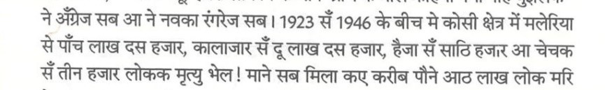
मूल दिनेश कुमार मिश्र (दुइ पाटन के बीच में... २००६):
भारतवर्ष
में बिहार में कोसी नदी को बांधने का काम
12वीं
शताब्दी में किसी राजा लक्ष्मण द्वितीय ने करवाया था और इस काम के लिए
उसने प्रजा से
'बीर' की उपाधि पाई और नदी का तटबन्ध
'बीर बांध' कहलाया।
इस तटबन्ध के अवशेष अभी भी सुपौल जिले में भीम नगर से कोई
5
किलोमीटर
दक्षिण में दिखाई पड़ते हैं। डॉ. फ्रांसिस बुकानन (1810-11)
का
अनुमान था कि यह बांध किसी किले की सुरक्षा के लिए बनी बाहरी दीवार रहा
होगा क्योंकि यह बांध धौस नदी के पश्चिमी किनारे पर तिलयुगा से उसके
संगम तक
32
किलोमीटर की दूरी में फैला हुआ था। डॉ. डब्लू.डब्लू. हन्टर (1877)
बुकानन के इस तर्क के साथ सहमत नहीं थे कि यह बांध किसी किले की
सुरक्षा दीवार था। स्थानीय लोगों के हवाले से हन्टर का मानना था कि
अधिकांश लोग इसे किले की दीवार नहीं मानते और उनके हिसाब से यह कुछ और
ही चीज थी मगर वह निश्चित रूप से कुछ कहने की स्थिति में नहीं थे। फिर
भी जो आम धारणा बनती है वह यह है कि यह कोसी नदी के किनारे बना कोई
तटबन्ध रहा होगा जिससे नदी की धारा को पश्चिम की ओर खिसकने से रोका जा
सके। लोगों का यह भी कहना था कि ऐसा लगता था कि इस तटबन्ध का निर्माण
कार्य एकाएक रोक दिया गया होगा।
छद्म समीक्षक कमलानन्द झा द्वारा चोर उपन्यासकारक पीठ ठोकब, देखू छद्म समीक्षक कमलानन्द झा द्वारा उद्धृत चोर पंकज झा पराशर (मैथिली उपन्यास, समय, समाज आ सवाल पृ. २५७-२५८):
चोर पंकज झा पराशर (साहित्य अकादेमीक मैथिली परामर्शदात्री समितिक सदस्य) [जलप्रांतर २०१७ (पृ. ३१)]:
मूल दिनेश कुमार मिश्र (दुइ पाटन के बीच में... २००६): कोसी के प्रवाह कि भयावहता की एक झलकफिरोजशाह तुगलक की फौज के सन् 1354 में बंगाल से दिल्ली लौटने के समय मिलती है। बताया जाता है कि जब सुल्तान की फौजें कोसी के किनारे पहुँचीं तो देखा कि नदी के दूसरे किनारे पर हाजी शम्सुद्दीन इलियास की फौजें मुकाबले के लिए तैयार खड़ी हैं। यह वही हाजी शम्सुद्दीन थे जिन्होंने हाजीपुर तथा समस्तीपुर शहर बसाये थे। फिरोज की फौजें शायद कुरसेला के आस-पास किसी जगह पर कोसी के किनारे सोच में पड़ गईं। नदी की रफ्तार उन्हें आगे बढ़ने से रोक रही थी। आखिरकार फैसला हुआ कि नदी के साथ-साथ उत्तर की ओर बढ़ा जाय और जहाँ नदी पार करने लायक हो जाय वहाँ पानी की थाह ली जाये। सुल्तान की फौजें प्रायः सौ कोस ऊपर गईं और जियारन के पास, जो कि उसी स्थान पर अवस्थित था जहाँ नदी पहाड़ों से मैदानों में उतरती थी, नदी को पार किया। नदी की धारा तो यहाँ पतली जरूर थी पर प्रवाह इतना तेज था कि पाँच-पाँच सौ मन के भारी पत्थर नदी में तिनकों की तरह बह रहे थे। जहाँ नदी को पार करना मुमकिन लगा उसके दोनों ओर सुल्तान ने हाथियों की कतार खड़ी कर दी और नीचे वाली कतार में रस्से लटकाये गये जिससे कि यदि कोई आदमी बहता हुआ हो तो इस रस्सों की मदद से उसे बचाया जा सके। शम्सुद्दीन ने कभी सोचा भी न था कि सुल्तान की फौजें कोसी को पार कर लेंगी और जब उस को इस बात का पता लगा कि सुलतान की फौजों ने कोसी को पार करने में कामयाबी पा ली है तो वह भाग निकला।
चोर पंकज झा पराशर (साहित्य अकादेमीक मैथिली परामर्शदात्री समितिक सदस्य) [जलप्रांतर २०१७ (पृ. १०५)]:
Original Dinesh Kumar Mishra (Dui Patan Ke Bich Mein... 2006): It is noteworthy that between 1923 and 1946, in the Kosi region, 510,000 died from malaria, 210,000 from kala-azar, 60,000 from cholera, and 3,000 from smallpox (total 783,000).
Plagiarist Pankaj Jha Parashar (Member, Sahitya Akademi Maithili Advisory Committee) [Jalprantar 2017 (p. 103)]:
Original Dinesh Kumar Mishra (Dui Patan Ke Bich Mein... 2006): The work of damming the Kosi river in Bihar in India was done in the 12th century by a king named Lakshmana II, and for this work, he received the title 'Bir' from his subjects, and the river embankment came to be called 'Bir Bandh'. Remains of this embankment are still visible about 5 kilometers south of Bhimnagar in Supaul district. Dr. Francis Buchanan (1810-11) estimated that this dam might have been an outer wall for the security of some fort, as it extended for 32 kilometers from the western bank of the Dhaus river to its confluence with the Tilyuga. Dr. W.W. Hunter (1877) disagreed with Buchanan's argument that this dam was a fort's defensive wall. Citing locals, Hunter believed that most people did not consider it a fort wall and according to them, it was something else, but he was not in a position to say for sure. Still, the common notion is that it must have been some embankment on the bank of the Kosi river to prevent its current from shifting westwards. People also said that it seemed the construction of this embankment was stopped abruptly.
Pseudo-critic Kamalanand Jha applauding the plagiarist novelist, see the citation by pseudo-critic Kamalanand Jha of plagiarist Pankaj Jha Parashar (Maithili novel, Samay, Samaj aur Sawal pp. 257-258):
Plagiarist Pankaj Jha Parashar (Member, Sahitya Akademi Maithili Advisory Committee) [Jalprantar 2017 (p. 31)]:
Original Dinesh Kumar Mishra (Dui Patan Ke Bich Mein... 2006): A glimpse of the horror of the Kosi's flow is seen when Firoz Shah Tughlaq's army returned from Bengal to Delhi in 1354. It is said that when the Sultan's forces reached the banks of the Kosi, they saw the forces of Haji Shamsuddin Ilyas ready for battle on the other side. This was the same Haji Shamsuddin who founded the cities of Hajipur and Samastipur. Firoz's forces perhaps pondered on the banks of the Kosi somewhere near Kursela. The river's speed prevented them from advancing. Finally, it was decided to proceed north along the river and find a place to measure the depth where crossing became feasible. The Sultan's forces went about 100 kos upstream and crossed the river near Jiyaran, which was located where the river descends from the mountains to the plains. The current was narrower here, but the flow was so fast that heavy stones weighing five hundred man were flowing like straw. Where crossing seemed possible, the Sultan lined up elephants on both sides, and ropes were hung from the lower line so that if anyone was swept away, they could be rescued. Shamsuddin never imagined the Sultan's forces would cross the Kosi, and when he learned they had succeeded, he fled.
Plagiarist Pankaj Jha Parashar (Member, Sahitya Akademi Maithili Advisory Committee) [Jalprantar 2017 (p. 105)]:
Dinesh Kumar Mishra: Development and Ideological Departure of a Multifaceted Personality
Dinesh Kumar Mishra was born in 1946 (according to some sources, 1948) in Azamgarh district, Uttar Pradesh. His educational background was connected to India's top technical institutions. He obtained a B.Tech. in Civil Engineering from the Indian Institute of Technology (IIT), Kharagpur, in 1968, and later an M.Tech. in Structural Engineering from the same institution in 1970. The ideological turning point in his life came in 1984 when, witnessing the devastation caused by the Kosi embankment breach in Saharsa, he was compelled to question whether modern engineering was actually providing solutions or making problems more complex. By the time he received his doctorate from Veer Narmad South Gujarat University in 2006, Mishra had established himself as an active environmentalist and river historian.
Mishra's methodology exhibits a unique duality: on one hand, he possesses the technical perspective of an IIT; on the other, he attempts to understand the cultural existence of rivers through folk tales, myths, songs, and poetry. His selection as an 'Ashoka Fellow' and being honored with the 'Bhagirath Prayas Samman' (2016) are proof that his research has taken the form of a broader social movement.
Bandini Mahananda: River's Liberation and the Trap of Embankments
The very title 'Bandini Mahananda' expresses Mishra's fundamental principle, where he terms embankments as a 'prison' for rivers. The Mahananda, a border river flowing between Bihar and Bengal, has been a victim of technical interventions that have disrupted its natural dynamics for decades. Mishra argues that the policy of confining rivers like the Mahananda within embankments not only increased the devastation of floods but also severed the centuries-old cultural and ecological relationship between the river and its riparian communities, which he calls 'cultural ownership'.
Economics of Embankments and Technical Analysis of Failure
Mishra understood in great detail how silt accumulation inside embankments causes the riverbed to rise above the surrounding land, turning the embankment into a 'time bomb'. His studies in the Mahananda basin show that despite massive investments in 'flood-control' according to government data, the flood-prone area continuously increased. He calls this 'Engineering Witchcraft', where technical solutions ignore local topography and hydrology.
Ecological Impact and the Problem of 'Water-logging'
A major problem in the context of the Mahananda is waterlogging. Embankments not only prevent river water from going out but also hinder rainwater from outside areas from merging into the river. As a result, agricultural land remains submerged for months, devastating the rabi crop and local livelihoods. Mishra's research points out that traditionally, people here knew how to 'live with floods', where floodwater increased soil fertility, not destruction.
Mithila's Water History and the 1948 Legislative Debate
To understand the policy shifts towards rivers, Dinesh Kumar Mishra also deeply analyzed the political debates soon after independence. The debate in the Bihar Legislative Assembly on September 18, 1948, is extremely important in this regard. In that debate, leaders like Deep Narayan Singh, Prabhunath Singh, and Murli Manohar Prasad expressed their views on floods and embankments.
Murli Manohar Prasad lamented the destruction of the prevalent irrigation system of that time and understood how the Indigo Planters had prevented the maintenance of old canals and sluice gates, causing the entire system to collapse. This debate clarifies that the demand for embankments was often made for immediate relief, while the scientific understanding of long-term impacts was disputed even then.
Bagmati and Kosi: The Tragedy of Communities Imprisoned within Embankments
A large part of Dinesh Kumar Mishra's research focuses on the human crisis of communities trapped between the embankments of the Bagmati and Kosi rivers. In the context of the Bagmati project, he studied villages like 'Masaha Alam' in Sitamarhi district, where out of 420 families, only 104 could be rehabilitated after forty years. These families are still forced to live in hellish conditions on the embankment or by the railway line.
Mishra notes that corruption in these projects was such that officials demanded 'nazarana' or a 10% commission even for the small plots allocated to the displaced. When the villagers of Masaha Alam refused to pay this bribe, they were deprived of rehabilitation for decades.
Barh Mukti Abhiyan: Empowering Communities
Dinesh Kumar Mishra is not just a writer; he also leads an active people's movement through the 'Barh Mukti Abhiyan'. This movement organizes communities in flood-prone areas of North Bihar to revive decentralized and traditional methods of flood management.
Mishra believes the most effective way to deal with floods is to rejuvenate the drainage systems of chaurs (local water bodies). He has provided technical assistance to many groups so they can carry out drainage work themselves and restart agriculture on land that became useless due to waterlogging.
Portrayal of Rivers in Maithili Literature and Ideological Struggle
The portrayal of rivers in Maithili literature has been not just as natural scenery, but also as a symbol of human struggle. The works of Dinesh Kumar Mishra provided many authors with a factual basis.
However, a 'Parallel Stream' has emerged in Maithili intellectual circles, opening a front against government academies and established critics. In this struggle, the 'biographies' of rivers by Dinesh Kumar Mishra are being used like an ideological weapon.
Terminology and Discourse: From 'Engineering Witchcraft' to 'Cultural Ownership'
The terminology used in Dinesh Kumar Mishra's research reflects the depth of his ideological discourse. Through 'Engineering Witchcraft', he attacks the modern superstition that believes concrete structures can completely control nature. In contrast, his concept of 'Cultural Ownership' suggests that the right to manage rivers should belong to the local communities who have lived with them for centuries.
Mishra argues that modern flood control policy creates 'reciprocal inaccessibility' – during floods, reaching affected areas becomes impossible, and during calm periods, waterlogging keeps those areas cut off from the mainstream of development.
Future Challenges and Relevance of Research
Today, with climate change altering rainfall patterns, the relevance of Dinesh Kumar Mishra's research has only increased. His predictions about the Kosi and Mahananda, made decades ago, are proving true. He is currently working on the Gandak and Ghaghra rivers to create a complete 'ecological map' of North Bihar's rivers.
Mishra's work is not just for policymakers but also serves as a guide for sociologists and literary figures. He reminds us that rivers are not just cubic seconds of water, but carriers of "forests, mountains, and the blessings of sages," and preserving their sanctity and freedom is our collective responsibility.
Dr. Mishra's work is not limited to the Kosi; he has written the "biography" of almost all major rivers of Mithila.
• Mahananda: His book "Bandini Mahananda" (1994) highlights the problems of the border river between Bihar and Bengal.
• Bagmati: In "Bagmati Ki Sadgati!" (2012), he showed how a river that was a boon became a "curse" due to embankments.
• Kamla: His research on the Kamla river and the struggles of its people in "Kamla River and People on Collision Course" is highly significant.
• Bhutahi Balan: In "Bhutahi Nadi Aur Takniki Jhad-Phook", he showed how engineering arrogance failed to control an unstable river.
• Gandak: He is currently working on the history of the Gandak and Ghaghra rivers, which would complete the river-scape of North Bihar.
Dr. Mishra and BMA's fundamental insistence is on the art of "living with floods". The people of Mithila earlier managed water through "chaurs", "dhaap", and "dhaar". The silt-laden water used to go to fields, leading to bumper yields of foxnut, fish, and paddy.
However, current government policy focuses on large projects like "river linking" and "national waterways" (National Waterways Act, 2016). There are plans to make the Gandak (NW-37) and Kosi (NW-58) national waterways to connect Nepal to the sea. Dr. Mishra warns that these projects ignore the serious problem of silt and could cause further ecological damage.
Dr. Dinesh Kumar Mishra's journey extends from IIT's "rigid engineering" to Mithila's "soft folk culture". His work proves that a river is not just a water stream, but the artery of society. The Barh Mukti Abhiyan is not just opposition to government policy, but a call for society to turn back to its roots.
If we want to save North Bihar from destruction, we must learn from Dr. Mishra's "flood history" and give engineering a human face, making it nature-friendly.
The place of rivers in the geographical, social, and cultural consciousness of Mithila is not limited to being a source of water; it is the very foundation of its civilization. When we talk about Mithila's rivers, a picture of floods, displacement, and struggle emerges, which cannot be understood with just an engineering degree. Making this serious subject the goal of his life, Dr. Dinesh Kumar Mishra established a discourse that challenges the failure of modern water management policy based on folk memory and historical evidence.
Introducing Dr. Dinesh Kumar Mishra merely as a river expert would be an injustice to his extensive research and struggle. He is a 'river-historian' who used his technical education not to 'control' rivers, but to convey the river's 'pain' to the public. His writings, known as timeless works like Bandini Mahananda, Dui Patan Ke Bich Mein, Bagmati Ki Sadgati, and Bagavat Par Majboor Mithila Ki Kamla Nadi, are essential documents for understanding Mithila's water culture and the politics of floods.
Personal and Educational Background: Transformation of an Engineer
Dinesh Kumar Mishra was born in 1948. His educational journey is highly impressive, strengthening the scientific basis of his research. In 1968, he obtained a B.Tech. (Hons.) in Civil Engineering from IIT Kharagpur. Subsequently, in 1970, he earned an M.Tech. in Structural Engineering from the same institute. This engineering background helped him understand the prevalent 'technical supremacy' of the time, which believed that a river could be controlled by damming it with cement and stone walls.
From 1970 to 1984, Dr. Mishra worked as an independent structural consultant. During this period, he designed and supervised the construction of large structures like university buildings, townships, cinema halls, and hospitals. However, the scene he witnessed in 1984 when the Kosi embankment broke at Nauhatta in Saharsa district changed the direction of his life. On September 5, 1984, the Kosi embankment near Hempur village breached, displacing about 500,000 people. After witnessing this tragedy, Mishra left his professional career and dedicated himself to the serious study of river behavior and the problems of flood victims.
Barh Mukti Abhiyan: Conflict between Folk Science and Government Policy
In 1992, Dr. Dinesh Kumar Mishra founded the 'Barh Mukti Abhiyan' (BMA). This is not a traditional NGO, but a people's movement and ideological platform opposing the 'embankment politics' being pursued in the name of flood control. Mishra's main argument is that flood is not just a natural disaster, but the result of government mismanagement and flawed engineering.
According to Mishra, the objective of the Barh Mukti Abhiyan is to inspire people to revive their 'flood memory'. He went from village to village training 'flood historians' who document how floods used to come to villages before the embankments and how people welcomed them. The ideological framework of BMA is based on the following points:
• Living with Floods: Mishra believes stopping floods is impossible; the only option is to create harmony with them.
• Failure of Embankments: Embankments trap river silt, causing the riverbed to rise and making floods more severe.
• Decentralized Solutions: Instead of large dams and embankments, rejuvenate small drainage systems and traditional ahar-pyne systems.
The Story of the Kosi: 'Dui Patan Ke Bich Mein' and the Tragedy of Displacement
Dr. Mishra's most discussed and serious research is 'Dui Patan Ke Bich Mein - Kosi Nadi Ki Kahani' (2006). In this book, he presents a comprehensive canvas, from the mythological context of the Kosi river to the modern history of embankments. The Kosi, called 'Bihar's Sorrow', is in Mishra's view the 'engineer's sorrow' and the 'politician's boon'.
In this book, he discusses the 'Bir Bandh' built by King Lakshmana II in the 12th century, whose remains can still be seen in Bhimnagar, Supaul district. Mishra proves that embankments were built in ancient times as well, but they were not for blocking the river's flow, but for defensive purposes. When the Kosi project started in the 1950s, it was claimed that embankments would end floods. But Mishra shows with data that the flood-affected area in Bihar, which was 2.5 million hectares in 1954, increased to 6.88 million hectares by 2008.
Another significant book of his, 'Trapped! Between the Devil and Deep Waters' (2008), was published just before the Kosi's Kushaha tragedy, almost like a prophecy. In this book, he clearly stated that when the river's surface rises inside the embankments, it could change its course at any time. Exactly that happened in 2008, when the Kosi breached the embankment to take its old course, flowing east.
Historical Death and Disease Data in the Kosi Region
In his research, Mishra presents horrifying data from 1923 to 1946, showing how waterlogging caused by railway and road construction during the British era took people's lives.
| Disease | Number of Deaths (1923-1946) |
| : | : |
| Malaria | 510,000 |
| Kala-azar | 210,000 |
| Cholera | 60,000 |
| Smallpox | 3,000 |
| Total Deaths | 783,000 |
Mishra argues that when floods bring water that flows, diseases do not spread. But when water stagnates due to embankments, mosquitoes breed and epidemics spread.
The Plight of Bagmati: 'Bagmati Ki Sadgati!' and Technical Intervention
The Bagmati river is considered highly sacred in Mithila, but in his book 'Bagmati Ki Sadgati!', Dr. Mishra exposed government efforts to destroy this sanctity. The attempt to confine Bagmati, known for changing its course, within embankments proved to be a major failure.
In this, he mentions the polluted water from the 'Riga Sugar Mill' contaminating Bagmati. He uses the term 'Engineering Witchcraft', meaning attempting to control the river merely with concrete without understanding its behavior. Earlier, Bagmati's flood used to fill chaurs, benefiting the 'Garma' crop and increasing fish production. After the embankment, water could not reach the fields, and villages became victims of waterlogging.
Kamla River and People's Revolt: 'Bagavat Par Majboor Mithila Ki Kamla Nadi'
The Kamla river is given the status of 'Mother' in Mithila. Dr. Mishra's book 'The Kamla River and People On Collision Course' describes the geography and irrigation history of the Kamla. From the start of irrigation schemes on the Kamla in the 1950s to the construction of the weir in 1964, Mishra highlights each technical failure.
In the context of the Kamla river, Mishra's main finding is that the people here used the water of 'Kamla' through their traditional ahar-pyne systems. When the government built embankments, water stopped reaching people's fields. Consequently, people often cut the embankment themselves ('public cut') to save their fields. According to Mishra, this 'revolt' is not against the river, but against flawed engineering.
Mahananda's Compulsion: 'Bandini Mahananda' and Politics
Published in 1994, 'Bandini Mahananda' was one of Mishra's early research works. In it, he raised the issue of the Mahananda river flowing on the border of Bihar and West Bengal. The Mahananda's embankment also caused border disputes. In his research, Mishra references the 1937 Patna Flood Conference, where Chief Engineer Captain Hall clearly stated that building embankments in North Bihar was an 'engineering sin'. But politicians ignored this warning to promote their vote banks and contractor practices.
Mishra's analysis shows that the Mahananda's embankment completely destroyed the agricultural cycle of that region. The water that previously brought fertility now causes crops to rot due to months-long waterlogging.
Technical Discourse: Embankments and the Silt Problem
Being a civil engineer, Dr. Mishra explains the failure of embankments on a scientific basis. Rivers originating from the Himalayas carry huge amounts of silt.
• Rising Riverbed: When a river is confined within embankments, silt cannot escape and accumulates in the riverbed, raising its surface by an average of 10 cm per year.
• Embankment Height: As the river rises, the government keeps increasing the embankment height, but there is a limit. When the embankment breaks, the water velocity becomes far more devastating.
• Benefit-Cost Ratio (BC Ratio): According to Mishra, engineers only consider the benefits of construction. They do not calculate the 'social cost' of displacement, disease, and land degradation.
Literary Contribution and the 'Videha' Movement
Dinesh Kumar Mishra is not originally from Mithila (he was born in Uttar Pradesh), but his work on Mithila's rivers is so profound that Maithili literature and journalism have honored him as a 'son of Mithila'. The importance of his work is such that he also became a victim of literary theft. Gajendra Thakur, editor of the Maithili magazine 'Videha', highlighted the case where Pankaj Jha 'Parashar', a member of the Sahitya Akademi's Maithili Advisory Committee, plagiarized several paragraphs from Mishra's book 'Dui Patan Ke Bich Mein' and published them under his name in his novel 'Jalprantar'. This controversy proved that Mishra's research has a 'literary value' that an ordinary writer cannot assimilate without deep study.
All of Mishra's books are now freely available in the 'Videha Archive', with his permission for Maithili-speaking readers.
Awards, Honors, and International Presence
Dr. Dinesh Kumar Mishra's work has been honored with several prestigious national and international awards. He was a member of the United Nations Environment Programme's (UNEP) 'Dams and Development Forum' (2003-07), where he represented people affected by dams. Additionally, he was a member of the 'Flood Control' working group for India's 11th and 12th Five-Year Plans, advocating for policy-level changes.
Conclusion: River's Liberation and the Path Ahead
Dinesh Kumar Mishra's entire life is dedicated to Mithila's rivers and the struggles of its people. His ideas move from 'flood control' to 'flood management' and 'harmony with rivers'. Today, as climate change increases flood devastation, Mishra's philosophy of 'Living with Floods' has become even more relevant.
His writing warns us that if we obstruct the natural flow of rivers, nature will settle the score. Mithila's Mahananda, Kosi, Bagmati, and Kamla are not just water-carrying streams; they are the life, culture, and identity of the people. The ideological foundation Dr. Mishra has provided to save this identity will guide many generations to come.
The society of Mithila will forever be indebted to Dr. Dinesh Kumar Mishra for this herculean effort. His work teaches us that when an engineer thinks with his heart, he does not remain confined to dams but also preserves people's 'memory'.
Nita Naval Dinesh Kumar Mishra
Dinesh Kumar Mishra, B.Tech. in Civil Engineering (1968) and M.Tech. in Structural Engineering (1970) from IIT Kharagpur. Expert on floods in Mithila. Has published books on almost all major rivers of Mithila, such as Uttar Bihar Ki Vyatha Katha (1990), Kosi- Umar Kaid Se Saza-E-Maut Tak (1992), Bandini Mahananda (1994), Boya Ped Babool Ka- Baadh Niyantran Ka Rahasya (2000), Bagavat Par Majboor Mithila Ki Kamla Nadi (2004), Bhutahi Nadi Aur Takniki Jhad-Phook (2005), Dui Patan Ke Bich Mein- Kosi Nadi Ki Kahani (2006), and Bagmati Ki Sadgati (2010).
Bibliography
1. Publics@IIHS - Indian Institute for Human Settlements, accessed February 11, 2026, https://iihs.co.in/iihs-events/publics/
2. Dinesh Kumar Mishra Books - Rajkamal Prakashan, accessed February 11, 2026, https://rajkamalprakashan.com/author/dinesh-kumar-mishra
3. 3 International Conference on Public Policy (ICPP3) June 28-30, 2017 -- Singapore Panel T16 P11 Session II P11 Sustainable Dev, accessed February 11, 2026, https://www.ippapublicpolicy.org/file/paper/593badf05daf1.pdf
4. Dinesh Kumar Mishra -- SANDRP, accessed February 11, 2026, https://sandrp.in/tag/dinesh-kumar-mishra/
5. Dinesh Kumar Mishra - Wikipedia, accessed February 11, 2026, https://en.wikipedia.org/wiki/Dinesh_Kumar_Mishra
6. Dr. Dinesh Kumar Mishra - Soanas, accessed February 11, 2026, https://soanas.org/aurthor/dr-dinesh-kumar-mishra/
7. Tag: Embankments - SANDRP, accessed February 11, 2026, https://sandrp.in/tag/embankments/
8. Dinesh Kumar Mishra | Ashoka, accessed February 11, 2026, https://www.ashoka.org/en/fellow/dinesh-kumar-mishra
9. Embankments -- SANDRP, accessed February 11, 2026, https://sandrp.in/category/embankments/
10. JAGDISH PRASAD MANDAL: MAITHILI WRITER Era Before and After, accessed February 11, 2026, https://archive.org/download/maithili_202209/JPM_MW_Gajendra_Thakur.pdf
11. Bhagirath Prayas Samman for Dineshkumar Mishraji: Helping us understand Rivers and Floods - SANDRP, accessed February 11, 2026, https://sandrp.in/2016/12/02/bhagirath-prayas-samman-for-dineshkumar-mishraji-helping-us-understand-rivers-and-floods/
12. वि दे ह - विदेह प्रथम मैथिली पाक्षिक ई पत्रिका, accessed February 11, 2026, https://www.videha.co.in/new_page_4.htm
13. Videhajournal's Blog, accessed February 11, 2026, https://videhajournal.wordpress.com/
14. ४. अनुलग्नक (पृ. १-४२८), accessed February 11, 2026, https://gajendrathakur123.files.wordpress.com/2023/06/videha_archive_july_2023_version.pdf
15. Bagmati - SANDRP, accessed February 11, 2026, https://sandrp.in/tag/bagmati/
16. एक इंजीनियर, जो नदियों का होकर रह गया : दिनेश कुमार मिश्रा - India Water Portal, accessed February 11, 2026, https://hindi.indiawaterportal.org/river-and-pond/eka-injainaiyara-jao-nadaiyaon-kaa-haokara-raha-gayaa-dainaesa-kaumaara-maisaraa
17. विदेह प्रथम मैथिली पाक्षिक ई पत्रिका, accessed February 11, 2026, https://www.videha.co.in/new_page_4.htm
18. Kamala River - Wikipedia, accessed February 11, 2026, https://en.wikipedia.org/wiki/Kamala_River
19. Knowing Kamla's sorrow could control Bihar floods - India Water Portal, accessed February 11, 2026, https://www.indiawaterportal.org/agriculture/livelihoods/knowing-kamlas-sorrow-could-control-bihar-floods
20. History of flood in Bihar - FMISC WRD Bihar, accessed February 11, 2026, https://fmiscwrdbihar.gov.in/fmis/historyFlood.aspx
21. Dinesh Kumar Mishra -- SANDRP - South Asia Network on Dams, Rivers and People, accessed February 11, 2026, https://sandrp.in/tag/dinesh-kumar-mishra/
22. Embankments -- SANDRP, accessed February 11, 2026, https://sandrp.in/category/embankments/
23. Refugees of the Kosi embankments -- A booklet by Dinesh Kumar Mishra - India Water Portal, accessed February 11, 2026, https://www.indiawaterportal.org/governance-and-policy/governance/refugees-kosi-embankments-booklet-dinesh-kumar-mishra
24. Floods in Bihar - Wikipedia, accessed February 11, 2026, https://en.wikipedia.org/wiki/Floods_in_Bihar
25. Refugees of the Kosi - AWS, accessed February 11, 2026, https://prod-qt-images.s3.amazonaws.com/indiawaterportal/import/sites/default/files/iwp2/refugees_of_kosi_embankments_dinesh_kumar_mishra.pdf
26. Flood frequency and flood intensity changes in the post embankment period in the Kosi sub-basin India: Impact of location, caste, and class on the flood vulnerability of the marginal communities - ResearchGate, accessed February 11, 2026, https://www.researchgate.net/publication/367436924_Flood_frequency_and_flood_intensity_changes_in_the_post_embankment_period_in_the_Kosi_sub-basin_India_Impact_of_location_caste_and_class_on_the_flood_vulnerability_of_the_marginal_communities
27. महानंदा नदी अपडेट - बिहार,बाढ़ि और महानंदा, accessed February 11, 2026, https://mahanandariver.org/research/Mahananda-River-Update\-\--Bihar-Flood-and-Mahananda/465/
28. The Kosi and the Embankment Story - ResearchGate, accessed February 11, 2026, https://www.researchgate.net/publication/238683688_The_Kosi_and_the_Embankment_Story
29. EA16240Rural0Livelihoods0repl... - World Bank Documents, accessed February 11, 2026, https://documents1.worldbank.org/curated/en/494261468751537678/txt/EA16240Rural0Livelihoods0replacement.txt
30. bihar @ 2047 - vision document, accessed February 11, 2026, https://letsinspirebihar.org/LIB_2047.pdf
31. Geo-Textile in Riverbank-Embankment Protection Fro | PDF | Levee - Scribd, accessed February 11, 2026, https://www.scribd.com/document/921224983/Geo-textile-in-Riverbank-Embankment-Protection-Fro
32. बगावती के हिंदी अर्थ | bagaavatii meaning in Hindi | हिन्दवी - Hindwi, accessed February 11, 2026, https://www.hindwi.org/hindi-dictionary/meaning-of-bagaavatii
33. विद्रोह ,बगावत और आन्दोलन में क्या अंतर है ? - Quora, accessed February 11, 2026, https://hi.quora.com/%E0%A4%B5%E0%A4%BF%E0%A4%A6%E0%A5%8D%E0%A4%B0%E0%A5%8B%E0%A4%B9-%E0%A4%AC%E0%A4%97%E0%A4%BE%E0%A4%B5%E0%A4%A4-%E0%A4%94%E0%A4%B0-%E0%A4%86%E0%A4%A8%E0%A5%8D%E0%A4%A6%E0%A5%8B%E0%A4%B2%E0%A4%A8
34. Dr Dinesh kumar Mishra | "भारत में नदियों को माँ का दर्जा प्राप्त है और माँ केवल माँ है, वह संसाधन या शोक कभी नहीं हो सकती. नदियां प्रकृतिदत्त उपहार है एवं धरती पर साक्षात् ईश्वर स्वरुप हैं." (डॉ दिनेश कुमार मिश्र) बेहद सरल, सजीव और भावपूर्ण शब्दों में नदियों की भारतीय - BallotBoxIndia, accessed February 11, 2026, https://ballotboxindia.com/up/Dr-Dinesh-kumar-Mishra/5181183080549/
35. Situation Report - 3 Flood Situation in Bihar Date: 30th September 2024 (Wednesday) Time: 11:00 AM (IST) - India | ReliefWeb, accessed February 11, 2026, https://reliefweb.int/report/india/situation-report-3-flood-situation-bihar-date-30th-september-2024-wednesday-time-1100-am-ist
36. Flood-like situation in Kamala river in Jhjharpur. Old rail bridge submerged in water., accessed February 11, 2026, https://www.youtube.com/watch?v=9RGMui5nR9A&vl=en-US
37. Dinesh Kumar Mishra | Ashoka, accessed February 11, 2026, https://www.ashoka.org/en/fellow/dinesh-kumar-mishra
38. Engineering witchcraft in Bihar - India Water Portal, accessed February 11, 2026, https://www.indiawaterportal.org/agriculture/farm/engineering-witchcraft-bihar
39. Dinesh Kumar Mishra -- SANDRP - South Asia Network on Dams, Rivers and People, accessed February 11, 2026, https://sandrp.in/tag/dinesh-kumar-mishra/
40. Planners and engineers have contempt for commoners: Dinesh Mishra - D-Sector, accessed February 11, 2026, https://d-sector.org/article-det.asp?id=1312&idFor=1312
41. Dinesh Kumar Mishra | Ashoka, accessed February 11, 2026, https://www.ashoka.org/en/fellow/dinesh-kumar-mishra
42. Copy of FLOOD RELATED CONFLICTS1-12 PDF TRIAL mudra.pmd, accessed February 11, 2026, https://meghpyneabhiyan.files.wordpress.com/2013/10/about-contributors.pdf
43. वि दे ह - विदेह प्रथम मैथिली पाक्षिक ई पत्रिका, accessed February 11, 2026, https://www.videha.co.in/new_page_4.htm
44. JAGDISH PRASAD MANDAL: MAITHILI WRITER Era Before and After, accessed February 11, 2026, https://archive.org/download/maithili_202209/JPM_MW_Gajendra_Thakur.pdf
45. Story of a ghost river and engineering witchcraft - India Water Portal, accessed February 11, 2026, https://hindi.indiawaterportal.org/books/story-ghost-river-and-engineering-witchcraft
46. ACKNOWLEDGEMENT - XIMB, accessed February 11, 2026, http://www1.ximb.ac.in/users/fac/shambu/sprasad.nsf/23e5e39594c064ee852564ae004fa010/1ee28838646f61d3652570ce0031cddd/\$FILE/04_flood%20management%20in%20Bihar_03_21_50.doc
47. Between Devil Deep Waters | PDF - Scribd, accessed February 11, 2026, https://www.scribd.com/document/938307771/Between-Devil-Deep-Waters-2
48. Flood frequency and flood intensity changes in the post embankment period in the Kosi sub-basin India: Impact of location, caste, and class on the flood vulnerability of the marginal communities - ResearchGate, accessed February 11, 2026, https://www.researchgate.net/publication/367436924_Flood_frequency_and_flood_intensity_changes_in_the_post_embankment_period_in_the_Kosi_sub-basin_India_Impact_of_location_caste_and_class_on_the_flood_vulnerability_of_the_marginal_communities
49. accessed February 11, 2026, https://hindi.indiawaterportal.org/books/story-ghost-river-and-engineering-witchcraft:\~:text=Besides%2C%20the%20land%20of%20the,embankment%20of%20the%20Bhutahi%20Balan.
50. Embankments -- SANDRP, accessed February 11, 2026, https://sandrp.in/category/embankments/
51. Sri. Dinesh Kumar Mishra on the flooding of Kosi basin,2008 - India Water Portal, accessed February 11, 2026, https://www.indiawaterportal.org/governance-and-policy/governance/sri-dinesh-kumar-mishra-flooding-kosi-basin2008
52. Bihar's indigenous languages hold the key to water resilience - Down To Earth, accessed February 11, 2026, https://www.downtoearth.org.in/water/bihars-indigenous-languages-hold-the-key-to-water-resilience
53. CATALYZING CHANGE FOR RESILIENCE ACROSS BOUNDARIES - DPNet Nepal, accessed February 11, 2026, https://dpnet.org.np/uploads/files/Challenges%20in%20Nepal\'s%20Small%20Transboundary%20Rivers_compressed%202023-06-13%2008-54-14.pdf
54. An ontology of water and land in North Bihar, India - PURE.EUR.NL., accessed February 11, 2026, https://pure.eur.nl/files/42907398/1467_9655.13611.pdf
55. 'Everybody loves a good flood': the political and social transformation of the eastern Tarai (Nepal) through flood control infrastructures - OpenEdition Journals, accessed February 11, 2026, https://journals.openedition.org/ebhr/1555
56. Bihar Floods of 1987-I - SANDRP, accessed February 11, 2026, https://sandrp.in/2016/03/26/bihar-floods-of-1987-i/
57. Mapping long-term Transformation of Wetlands and Annual Rainfall Variability in Madhubani District (1975-2022) - Current World Environment, accessed February 11, 2026, https://www.cwejournal.org/vol1no1/pmapping-long-term-transformation-of-wetlands-and-annual-rainfall-variability-in-madhubani-district-1975-2022p
58. Mapping long-term Transformation of Wetlands and Annual Rainfall Variability in Madhubani District (1975-2022) - ResearchGate, accessed February 11, 2026, https://www.researchgate.net/publication/381044655_Mapping_long-term_Transformation_of_Wetlands_and_Annual_Rainfall_Variability_in_Madhubani_District_1975-2022
59. Uncategorized | Madhesi - United We Stand | Page 30, accessed February 11, 2026, https://madhesi.wordpress.com/category/uncategorized/page/30/
60. Rivers and Drainage System - BPSC Preparation: All subjects - BPSC (Bihar) PDF Download - EduRev, accessed February 11, 2026, https://edurev.in/t/380361/Rivers-and-Drainage-System
61. BIHAR RIVER ATLAS - cGanga, accessed February 11, 2026, https://cganga.org/wp-content/uploads/2025/05/10_Bihar-River-Atlas-2023.pdf
62. Dui Patan - People's Science Institute, accessed February 11, 2026, http://www.peoplesscienceinstitute.org/resource/techs/Dui%20Patan.html
63. As Kosi river keeps changing, ownership of land on its embankments under question - Mongabay-India, accessed February 11, 2026, https://india.mongabay.com/2022/05/as-kosi-river-keep-changing-ownership-of-land-on-its-embankments-under-question/
64. Dinesh Kumar Mishra -- SANDRP, accessed February 11, 2026, https://sandrp.in/tag/dinesh-kumar-mishra/
65. Dinesh Kumar Mishra | Ashoka, accessed February 11, 2026, https://www.ashoka.org/en/fellow/dinesh-kumar-mishra
66. 3 International Conference on Public Policy (ICPP3) June 28-30, 2017 -- Singapore Panel T16 P11 Session II P11 Sustainable Dev, accessed February 11, 2026, https://www.ippapublicpolicy.org/file/paper/593badf05daf1.pdf
67. Kosi River Flood Control Analysis | PDF | Levee | Flood - Scribd, accessed February 11, 2026, https://www.scribd.com/document/489389398/Between-Kosi-and-Bihar-Trapped-Between-t-pdf
68. Bihar: Kosi Project's Promise of Flood-Free Prosperity Remains a Distant Dream - The Wire, accessed February 11, 2026, https://m.thewire.in/article/science/bihar-kosi-project-flood
69. The Kosi and the Embankment Story - ResearchGate, accessed February 11, 2026, https://www.researchgate.net/publication/238683688_The_Kosi_and_the_Embankment_Story
70. Dinesh Kumar Mishra -- SANDRP - South Asia Network on Dams, Rivers and People, accessed February 11, 2026, https://sandrp.in/tag/dinesh-kumar-mishra/
71. ISSN 2229-547X VIDEHA विदेह ३६३ म अंक ०१ फरबरी २०२३ (वर्ष १६ मास, accessed February 11, 2026, https://dn720002.ca.archive.org/0/items/videha-262/VIDEHA_363_Kaithi.pdf
72. Dinesh Kumar Mishra - Wikipedia, accessed February 11, 2026, https://en.wikipedia.org/wiki/Dinesh_Kumar_Mishra
73. Dr. Dinesh Kumar Mishra - Soanas, accessed February 11, 2026, https://soanas.org/aurthor/dr-dinesh-kumar-mishra/
74. Bagmati -- SANDRP, accessed February 11, 2026, https://sandrp.in/tag/bagmati/
75. Reviewed Work(s): -- (i) Living with Floods: People's Perspective (ii) The Bihar Flood Story, accessed February 11, 2026, https://www.academia.edu/37270080/Reviewed_Work_s_i_Living_with_Floods_Peoples_Perspective_ii_The_Bihar_Flood_Story
76. Dinesh Kumar Mishra | Ashoka, accessed February 11, 2026, https://www.ashoka.org/en/fellow/dinesh-kumar-mishra
77. Embankments -- SANDRP, accessed February 11, 2026, https://sandrp.in/category/embankments/
78. (PDF) EXTREME FLOODS IN BAGMATI RIVER BASIN - ResearchGate, accessed February 11, 2026, https://www.researchgate.net/publication/264421419_EXTREME_FLOODS_IN_BAGMATI_RIVER_BASIN
79. Bihar farmers protest flood embankments to protect livelihoods | - Dialogue Earth, accessed February 11, 2026, https://dialogue.earth/en/water/bihar-farmers-protest-bagmati-river-embankments/
80. Bihar's indigenous languages hold the key to water resilience - Down To Earth, accessed February 11, 2026, https://www.downtoearth.org.in/water/bihars-indigenous-languages-hold-the-key-to-water-resilience
81. Understanding the floods of Bihar - Book review of "Bagmati Ki ..., accessed February 11, 2026, https://www.indiawaterportal.org/agriculture/farm/understanding-floods-bihar-book-review-bagmati-ki-sadgati
82. Flood frequency and flood intensity changes in the post embankment period in the Kosi sub-basin India: Impact of location, caste, and class on the flood vulnerability of the marginal communities - ResearchGate, accessed February 11, 2026, https://www.researchgate.net/publication/367436924_Flood_frequency_and_flood_intensity_changes_in_the_post_embankment_period_in_the_Kosi_sub-basin_India_Impact_of_location_caste_and_class_on_the_flood_vulnerability_of_the_marginal_communities
83. Dr Dinesh kumar Mishra | "भारत में नदियों को माँ का दर्जा प्राप्त है और माँ केवल माँ है, वह संसाधन या शोक कभी नहीं हो सकती. नदियां प्रकृतिदत्त उपहार है एवं धरती पर साक्षात् ईश्वर स्वरुप हैं." (डॉ दिनेश कुमार मिश्र) बेहद सरल, सजीव और भावपूर्ण शब्दों में नदियों की भारतीय - BallotBoxIndia, accessed February 11, 2026, https://ballotboxindia.com/up/Dr-Dinesh-kumar-Mishra/5181183080549/
84. Between Devil Deep Waters | PDF - Scribd, accessed February 11, 2026, https://www.scribd.com/document/938307771/Between-Devil-Deep-Waters-2
85. The Kosi and the Embankment Story - ResearchGate, accessed February 11, 2026, https://www.researchgate.net/publication/238683688_The_Kosi_and_the_Embankment_Story
86. Tag: Embankments - SANDRP, accessed February 11, 2026, https://sandrp.in/tag/embankments/
87. India Rivers Week -- Page 2 - SANDRP, accessed February 11, 2026, https://sandrp.in/category/india-rivers-week/page/2/
88. Dinesh Kr Mishra Pani ka Shap, Rajkamal Prakashan, 2026
89. Tag: Dinesh Kumar Mishra - SANDRP, accessed on February 13, 2026, https://sandrp.in/tag/dinesh-kumar-mishra/
90. Kosi River - Wikipedia, accessed on February 13, 2026, https://en.wikipedia.org/wiki/Kosi_River
91. India (Food Situation) - Hansard - UK Parliament, accessed on February 13, 2026, https://hansard.parliament.uk/commons/1943-10-12/debates/5e0b77aa-377a-467c-8188-b2ba6e0e5958/India(FoodSituation)
92. Grow More Food Campaign - GKToday, accessed on February 13, 2026, https://www.gktoday.in/grow-more-food-campaign/
93. The Essence of Kosi Treaty and Kosi High Dam, accessed on February 13, 2026, https://www.urjakhabar.com/en/news/0205719479
94. Sandeep Bhardwaj - Centre for Policy Research, accessed on February 13, 2026, https://cprindia.org/wp-content/uploads/2021/12/Institutional-Determinants-of-Indo-Nepal-Hydro-Cooperation_Abridged-Report_Sandeep-Bhardwaj.pdf
95. A dammed history of the Koshi | Dialogue Earth, accessed on February 13, 2026, https://dialogue.earth/en/water/koshi-river-bihar/
96. The Essence of Kosi Treaty and Kosi High Dam, accessed on February 13, 2026, https://urjakhabar.com/en/news/0205719479
97. Planners and engineers have contempt for commoners: Dinesh Mishra - D-Sector, accessed on February 13, 2026, https://d-sector.org/article-det.asp?id=1312&idFor=1312
98. Reflections on the Origin of the Kosi Project - SANDRP, accessed on February 13, 2026, https://sandrp.in/2015/04/04/reflections-on-the-origin-of-the-kosi-project/
99. Fighting Flood and Drought, Millions in Bihar Lose Livelihoods - The Wire Science, accessed on February 13, 2026, https://science.thewire.in/politics/government/bihar-flood-drought-crop-loss/
100. Drought - BIHAR STATE DISASTER MANAGEMENT AUTHORITY, accessed on February 13, 2026, http://bsdma.org/Know-Your-Risk.aspx?id=4
101. From 'Grow More Food' to 'Miss a Meal': Hunger, Development and the Limits of Post-Colonial Nationalism in India, 1947--1957 - ResearchGate, accessed on February 13, 2026, https://www.researchgate.net/publication/271667090_From_\'Grow_More_Food\'\_to\_\'Miss_a_Meal\'\_Hunger_Development_and_the_Limits_of_Post-Colonial_Nationalism_in_India_1947-1957
102. Food Crisis, Inflation and Political Control in Punjab (1940-47), accessed on February 13, 2026, https://punjab.global.ucsb.edu/sites/default/files/sitefiles/journals/volume20/11-Sukhdev%20Sohal%2020.pdf
103. A Tale of Two Countries -- Kosi - Surakshit Sansar - IISSM, accessed on February 13, 2026, https://surakshitsansar.iissm.in/a-tale-of-two-countries-kosi/
104. Indias Food Problem And Policy Since Independence, accessed on February 13, 2026, https://ia601507.us.archive.org/23/items/in.ernet.dli.2015.133139/2015.133139.Indias-Food-Problem-And-Policy-Since-Independence_text.pdf
105. Reviewed Work(s): -- (i) Living with Floods: People's Perspective (ii) The Bihar Flood Story, accessed on February 13, 2026, https://www.academia.edu/37270080/Reviewed_Work_s_i_Living_with_Floods_Peoples_Perspective_ii_The_Bihar_Flood_Story
106. Dinesh Kumar Mishra | Ashoka, accessed on February 13, 2026, https://www.ashoka.org/en/fellow/dinesh-kumar-mishra
107. Dr. Dinesh Kumar Mishra - Soanas, accessed on February 13, 2026, https://soanas.org/aurthor/dr-dinesh-kumar-mishra/
108. Dinesh Kr Mishra Pani ka Shap, Rajkamal Prakashan, 2026
109. FMISC WRD Bihar, accessed on February 13, 2026, https://fmiscwrdbihar.gov.in/fmis/history.html
110. Floods in Bihar - Wikipedia, accessed on February 13, 2026, https://en.wikipedia.org/wiki/Floods_in_Bihar
111. भारत में बाढ़ि प्रबंधन- एक सांख्यिकीि ररपोर्ट-२०२३ - Flood Management in India - A Statistical Report-2023 - Central Water Commission, accessed on February 13, 2026, https://cwc.gov.in/sites/default/files/flood-management-india-statistical-report-2023.pdf
112. 3,800 kilometres of embankments worsen floods in Bihar | Dialogue Earth, accessed on February 13, 2026, https://dialogue.earth/en/water/3800-kilometres-of-embankments-worsen-floods-in-bihar-2/
113. A tribute to Bharat Ratna Karpoori Thakur in Bihar - YouTube, accessed on February 13, 2026, https://www.youtube.com/shorts/D_y0Wpt8cjI
114. The Hydro-political History of the first Indo-Nepal Koshi River Agreement (1954) Souvik Dasgupta, accessed on February 13, 2026, https://www.epitomejournals.com/VolumeArticles/FullTextPDF/538_Research_Paper.pdf
115. The Essence of Kosi Treaty and Kosi High Dam, accessed on February 13, 2026, https://urjakhabar.com/en/news/0205719479
116. The shifting sands - Down To Earth, accessed on February 13, 2026, https://www.downtoearth.org.in/environment/the-shifting-sands-20767
117. BIHAR's FLOOD SURVIVAL MECHANISM - AWS, accessed on February 13, 2026, https://prod-qt-images.s3.amazonaws.com/indiawaterportal/import/sites/default/files/iwp2/floodissuecorel1_30.pdf
118. Agreement Between the Government of India and the Government of Nepal on the Kosi Project - International Water Law Project, accessed on February 13, 2026, https://www.internationalwaterlaw.org/documents/regionaldocs/kosi-river1.html
119. The Essence of Kosi Treaty and Kosi High Dam, accessed on February 13, 2026, https://www.urjakhabar.com/en/news/0205719479
120. Chapter 3 The Kosi River I. Introduction and History of the Kosi Project - Brill, accessed on February 13, 2026, https://brill.com/display/book/9789004480216/B9789004480216_s010.pdf
121. A dammed history of the Koshi | Dialogue Earth, accessed on February 13, 2026, https://dialogue.earth/en/water/koshi-river-bihar/
122. Refugees of the Kosi embankments -- A booklet by Dinesh Kumar Mishra - India Water Portal, accessed on February 13, 2026, https://www.indiawaterportal.org/governance-and-policy/governance/refugees-kosi-embankments-booklet-dinesh-kumar-mishra
123. Refugees of the Kosi - Himal Southasian, accessed on February 13, 2026, https://www.himalmag.com/essay/refugees-of-the-kosi
124. 13405 Calling Attentioyi 13 SEPTEMBER 1955 to Matter of Urgent Public Importance I Pandit Thakur Das Bhargava] Twenty-fifth Rep, accessed on February 13, 2026, https://eparlib.sansad.in/bitstream/123456789/894711/1/01_X_13-09-1955_p24_p25_PII.pdf
125. Embankments in Bihar: The inapt and futile defence against floods - India Water Portal, accessed on February 13, 2026, https://www.indiawaterportal.org/faqs/embankments-bihar-inapt-and-futile-defence-against-floods
126. Stagnating pools and the gandak command - India Water Portal, accessed on February 13, 2026, https://hindi.indiawaterportal.org/books/stagnating-pools-and-gandak-command
127. HISTORY OF INUNDATION IN NORTHERN BIHAR - Update Publishing House, accessed on February 13, 2026, https://updatepublishing.com/journal/index.php/rrst/article/download/508/493
128. History of flood in Bihar, accessed February 14, 2026, https://fmiscwrdbihar.gov.in/fmis/historyFlood.aspx
129. Floods in Bihar - Wikipedia, accessed February 14, 2026, https://en.wikipedia.org/wiki/Floods_in_Bihar
130. The Hydro-political History of the first Indo-Nepal Koshi River Agreement (1954) Souvik Dasgupta, accessed February 14, 2026, https://www.epitomejournals.com/VolumeArticles/FullTextPDF/538_Research_Paper.pdf
131. Dinesh Kr Mishra Pani ka Shap Part 2.pdf
132. A dammed history of the Koshi | Dialogue Earth, accessed February 14, 2026, https://dialogue.earth/en/water/koshi-river-bihar/
133. The Essence of Kosi Treaty and Kosi High Dam, accessed February 14, 2026, https://www.urjakhabar.com/en/news/0205719479
134. Chapter 3 The Kosi River I. Introduction and History of the Kosi Project - Brill, accessed February 14, 2026, https://brill.com/display/book/9789004480216/B9789004480216_s010.pdf
135. The shifting sands - Down To Earth, accessed February 14, 2026, https://www.downtoearth.org.in/environment/the-shifting-sands-20767
136. Weather in relation to the floods in Bihar, Bengal and Assam during July and August 1954 - MAUSAM Journal, accessed February 14, 2026, https://mausamjournal.imd.gov.in/index.php/MAUSAM/article/download/4893/4622/19246
137. Breach of trust - Down To Earth, accessed February 14, 2026, https://www.downtoearth.org.in/environment/breach\--of\--trust-20764
138. The hungry river: Looking through floods and silt in North Bihar | Oxford Policy Management, accessed February 14, 2026, https://www.opml.co.uk/insights/hungry-river-looking-through-floods-and-silt-north-bihar
139. (PDF) Floods and Environmental Justice in North Bihar: Contextual Vulnerabilities of Historically Marginalised Communities in the Kosi Sub-basin - ResearchGate, accessed February 14, 2026, https://www.researchgate.net/publication/373143825_Floods_and_Environmental_Justice_in_North_Bihar_Contextual_Vulnerabilities_of_Historically_Marginalised_Communities_in_the_Kosi_Sub-basin
140. HISTORY OF INUNDATION IN NORTHERN BIHAR - Update Publishing House, accessed February 14, 2026, https://updatepublishing.com/journal/index.php/rrst/article/download/508/493
141. ISSN 2229-547X VIDEHA विदेह ३६६ म अंक १५ मार्च २०२३ (वर्ष १६ मास, accessed February 14, 2026, https://archive.org/download/videha-262/VIDEHA_366_Kaithi.pdf
142. Dinesh Kr Mishra Pani ka Shap, Rajkamal Prakashan, 2026
143. A dammed history of the Koshi | Dialogue Earth, accessed February 14, 2026, https://dialogue.earth/en/water/koshi-river-bihar/
144. (PDF) Reinterpreting Flood: Studying the Historical Implication of Koshi Flood in Northern Bihar - ResearchGate, accessed February 14, 2026, https://www.researchgate.net/publication/368364859_Reinterpreting_Flood_Studying_the_Historical_Implication_of_Koshi_Flood_in_Northern_Bihar
145. A tragedy foretold - Asia Pacific Greens Federation (APGF), accessed February 14, 2026, https://asiapacificgreens.org/fre/news_statement/a-tragedy-foretold/
146. The Essence of Kosi Treaty and Kosi High Dam - ऊर्जा खबर, accessed February 14, 2026, https://www.urjakhabar.com/news/0205719479
147. The Essence of Kosi Treaty and Kosi High Dam, accessed February 14, 2026, https://urjakhabar.com/en/news/0205719479
148. Dinesh Kumar Mishra | Ashoka, accessed February 14, 2026, https://www.ashoka.org/en/fellow/dinesh-kumar-mishra
149. Breach of trust - Down To Earth, accessed February 14, 2026, https://www.downtoearth.org.in/environment/breach\--of\--trust-20764
150. Dinesh Kr Mishra Pani ka Shap, Rajkamal Prakashan, 2026
151. Dinesh Kumar Mishra - Wikipedia, accessed February 14, 2026, https://en.wikipedia.org/wiki/Dinesh_Kumar_Mishra
152. Principal's Message (Dr. Dinesh Kumar Mishra ) - Maryland Institute of Technology & Management, accessed February 14, 2026, http://www.mditm.com/principal-message.php
153. Tag: Dinesh Kumar Mishra - SANDRP, accessed February 14, 2026, https://sandrp.in/tag/dinesh-kumar-mishra/
154. Averse engineering - Down To Earth, accessed February 14, 2026, https://www.downtoearth.org.in/environment/averse-engineering-2856
155. Dinesh Kumar Mishra | Ashoka, accessed February 14, 2026, https://www.ashoka.org/en/fellow/dinesh-kumar-mishra
156. Kosi River Flood Control Analysis | PDF | Levee - Scribd, accessed February 14, 2026, https://www.scribd.com/document/489389398/Between-Kosi-and-Bihar-Trapped-Between-t-pdf
157. Engineering witchcraft in Bihar - India Water Portal, accessed February 14, 2026, https://www.indiawaterportal.org/agriculture/farm/engineering-witchcraft-bihar
158. Understanding the floods of Bihar - Book review of "Bagmati Ki Sadgati !" - India Water Portal, accessed February 14, 2026, https://www.indiawaterportal.org/agriculture/farm/understanding-floods-bihar-book-review-bagmati-ki-sadgati
159. Copy of FLOOD RELATED CONFLICTS1-12 PDF TRIAL mudra.pmd, accessed February 14, 2026, https://meghpyneabhiyan.files.wordpress.com/2013/10/about-contributors.pdf
160. Dr. Dinesh Kumar Mishra -- Soanas, accessed February 11, 2026, https://soanas.org/aurthor/dr-dinesh-kumar-mishra/
161. Dinesh Kumar Mishra -- SANDRP - South Asia Network on Dams, Rivers and People, accessed February 11, 2026, https://sandrp.in/tag/dinesh-kumar-mishra/
162. विदेह प्रथम मैथिली पाक्षिक ई पत्रिका, accessed February 11, 2026, https://www.videha.co.in/new_page_4.htm
163. विदेह पोथी - प्रथम मैथिली पाक्षिक ई पत्रिका, accessed February 11, 2026, https://www.videha.co.in/pothi.htm
164. Dinesh Kumar Mishra - Wikipedia, accessed February 11, 2026, https://en.wikipedia.org/wiki/Dinesh_Kumar_Mishra
165. Principal's Message (Dr. Dinesh Kumar Mishra ) - Maryland Institute of Technology & Management, accessed February 11, 2026, http://www.mditm.com/principal-message.php
166. एक इंजीनियर, जो नदियों का होकर रह गया : दिनेश कुमार मिश्रा - India Water Portal, accessed February 11, 2026, https://hindi.indiawaterportal.org/river-and-pond/eka-injainaiyara-jao-nadaiyaon-kaa-haokara-raha-gayaa-dainaesa-kaumaara-maisaraa
167. Dinesh Kumar Mishra | Ashoka, accessed February 11, 2026, https://www.ashoka.org/en/fellow/dinesh-kumar-mishra
168. A sustainable engineering disaster - Down To Earth, accessed February 11, 2026, https://www.downtoearth.org.in/environment/a-sustainable-engineering-disaster-3670
169. Flood frequency and flood intensity changes in the post embankment period in the Kosi sub-basin India: Impact of location, caste, and class on the flood vulnerability of the marginal communities - ResearchGate, accessed February 11, 2026, https://www.researchgate.net/publication/367436924_Flood_frequency_and_flood_intensity_changes_in_the_post_embankment_period_in_the_Kosi_sub-basin_India_Impact_of_location_caste_and_class_on_the_flood_vulnerability_of_the_marginal_communities
170. Bagmati - SANDRP, accessed February 11, 2026, https://sandrp.in/tag/bagmati/
171. Full text of "Videha Issues 251 TO 371 & Links to Devanagari, Tirhuta and Maithili-Braille issues 001 to 149" - Internet Archive, accessed February 11, 2026, https://archive.org/stream/videha-262/VIDEHA_363_djvu.txt
172. Between Devil Deep Waters | PDF - Scribd, accessed February 11, 2026, https://www.scribd.com/document/938307771/Between-Devil-Deep-Waters-2
173. Videhajournal's Blog, accessed February 11, 2026, https://videhajournal.wordpress.com/
174. A brief Review-Mathematical Modeling on Water Pollution and Its Effects on Aquatic Species, resembling Bagmati River - Research India Publications, accessed February 11, 2026, https://www.ripublication.com/ijaes22/ijaesv17n1_06.pdf
175. Embankments -- SANDRP, accessed February 11, 2026, https://sandrp.in/category/embankments/
176. बगावत पर मजबूर मिथिला की कमला नदी (The Kamla River and People ..., accessed February 11, 2026, https://hindi.indiawaterportal.org/books/bagaavata-para-majabauura-maithailaa-kai-kamalaa-nadai-kamla-river-and-people-collision
177. Reviewed Work(s): -- (i) Living with Floods: People's ... - Academia.edu, accessed February 11, 2026, https://www.academia.edu/37270080/Reviewed_Work_s_i_Living_with_Floods_Peoples_Perspective_ii_The_Bihar_Flood_Story
178. Tag: Embankments - SANDRP, accessed February 11, 2026, https://sandrp.in/tag/embankments/
179. (PDF) Special Section State, Floods and Politics of Knowledge: A Case of the Mahananda Basin of Bihar - ResearchGate, accessed February 11, 2026, https://www.researchgate.net/publication/383304730_Special_Section_State_Floods_and_Politics_of_Knowledge_A_Case_of_the_Mahananda_Basin_of_Bihar
180. Sri. Dinesh Kumar Mishra on the flooding of Kosi basin,2008 - India Water Portal, accessed February 11, 2026, https://www.indiawaterportal.org/governance-and-policy/governance/sri-dinesh-kumar-mishra-flooding-kosi-basin2008
181. विदेह ३७१ म अंक ०१ जून २०२३ (वर्ष१६ मास १८६ अंक ३७१ - Internet Archive, accessed February 11, 2026, https://archive.org/download/maithili_202209/VIDEHA_ARCHIVE_MAY_2023_VERSION_Kaithi.pdf
अपन मंतव्य editorial.staff.videha@zohomail.in पर पठाउ।